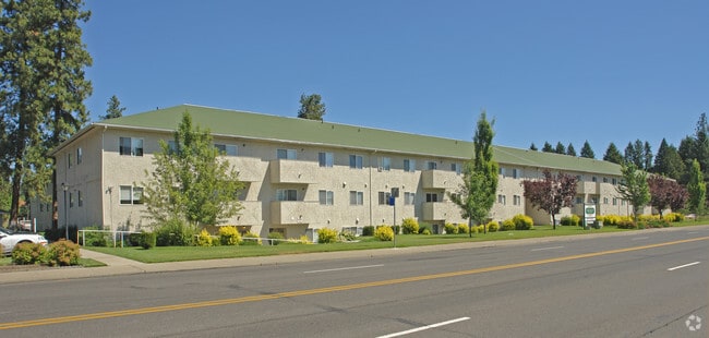
Property Record
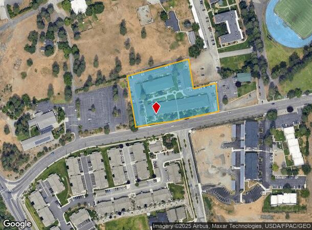
4150 W Whistalks Way, Spokane, WA 99224

NEARBY LISTINGS FOR SALE OR LEASE
Property Detail
4150 W Whistalks Way
25113.0056
Sp 9004
Apartment
TR B OF OGLE CITY SP 90-04 BEING A PTN OF SE1/4 OF SEC 10-25-42 & A PTN OF SW1/4 OF SEC 11-25-42; AUDITORS #9012130042
X
Spokane
53063C0536D
Washington
2025
2.50 AC
2025
West Spokane
003601
Spokane
48,600 SF
Spokane-Spokane Valley, WA
DEMOGRAPHICS near 4150 W Whistalks Way
1 Mile
3 Mile
5 Mile
2024 Total Population
3,508
70,225
187,157
2029 Population
3,727
74,743
199,030
Pop Growth 2024-2029
+ 6.24%
+ 6.43%
+ 6.34%
Average Age
35
39
39
2024 Total Households
1,454
31,714
77,215
HH Growth 2024-2029
+ 6.40%
+ 6.90%
+ 6.68%
Median Household Inc
$44,374
$53,652
$57,345
Avg Household Size
2.30
2.10
2.30
2024 Avg HH Vehicles
1.00
2.00
2.00
Median Home Value
$500,865
$283,326
$305,095
Median Year Built
2005
1952
1957
Nearby Places
Map Layers
Map Styles
 Street
 Aerial
- Restaurants
- Banks
- Shops
- Fitness
- Groceries
PUBLIC TRANSPORTATION
COMMUTER RAIL
Spokane (Empire Builder - Amtrak)
DRIVE
WALK
Distance
Spokane (Empire Builder - Amtrak)
10 min
3.8 mi
AIRPORT
Spokane International
DRIVE
WALK
Distance
Spokane International
14 min
6.6 mi
Freight Ports
Port of Everett
DRIVE
WALK
Distance
Port of Everett
343 min
303.5 mi
Nearby Properties
Address
Land Use
TOTAL SIZE
Lot Size
Zoning
Address
Land Use
TOTAL SIZE
Lot Size
Zoning
831,429 SF
119.79 AC
Address
Land Use
TOTAL SIZE
Lot Size
Zoning
157,882 SF
42.70 AC
DTG
Address
Land Use
TOTAL SIZE
Lot Size
Zoning
123,047 SF
3.95 AC
DTG
Address
Land Use
TOTAL SIZE
Lot Size
Zoning
241,106 SF
3.92 AC
CB
Address
Land Use
TOTAL SIZE
Lot Size
Zoning
536,438 SF
1.70 AC
DTC
Address
Land Use
TOTAL SIZE
Lot Size
Zoning
171,479 SF
67.30 AC
RSF
Address
Land Use
TOTAL SIZE
Lot Size
Zoning
154,800 SF
20.06 AC
DTG
Address
Land Use
TOTAL SIZE
Lot Size
Zoning
139,485 SF
16.74 AC
RSF
Address
Land Use
TOTAL SIZE
Lot Size
Zoning
107,800 SF
3.20 AC
CB
Address
Land Use
TOTAL SIZE
Lot Size
Zoning
91,882 SF
2.07 AC
OR
Address
Land Use
TOTAL SIZE
Lot Size
Zoning
314,149 SF
1.07 AC
DTC
Address
Land Use
TOTAL SIZE
Lot Size
Zoning
151,667 SF
7.45 AC
DTG
Address
Land Use
TOTAL SIZE
Lot Size
Zoning
289,705 SF
3.36 AC
OR
Address
Land Use
TOTAL SIZE
Lot Size
Zoning
50,869 SF
0.61 AC
DTC
Address
Land Use
TOTAL SIZE
Lot Size
Zoning
228,981 SF
5.32 AC
RHD
Address
Land Use
TOTAL SIZE
Lot Size
Zoning
182,088 SF
0.37 AC
DTC
Address
Land Use
TOTAL SIZE
Lot Size
Zoning
53,748 SF
1.26 AC
DTC
Address
Land Use
TOTAL SIZE
Lot Size
Zoning
124,249 SF
15.45 AC
RHD
Address
Land Use
TOTAL SIZE
Lot Size
Zoning
259,221 SF
5.06 AC
DTC
Address
Land Use
TOTAL SIZE
Lot Size
Zoning
67,831 SF
6.90 AC
DTG
Address
Land Use
TOTAL SIZE
Lot Size
Zoning
236,105 SF
5.01 AC
OR
Address
Land Use
TOTAL SIZE
Lot Size
Zoning
280,783 SF
4.91 AC
GC
Address
Land Use
TOTAL SIZE
Lot Size
Zoning
91,048 SF
3.81 AC
OR
Address
Land Use
TOTAL SIZE
Lot Size
Zoning
16,384 SF
1.21 AC
DTC
Address
Land Use
TOTAL SIZE
Lot Size
Zoning
127,826 SF
0.33 AC
DTG
Address
Land Use
TOTAL SIZE
Lot Size
Zoning
30,250 SF
1.05 AC
DTC
Address
Land Use
TOTAL SIZE
Lot Size
Zoning
177,044 SF
14.71 AC
LDR
Address
Land Use
TOTAL SIZE
Lot Size
Zoning
114,600 SF
0.87 AC
CB
Address
Land Use
TOTAL SIZE
Lot Size
Zoning
19,994 SF
0.63 AC
DTG
Address
Land Use
TOTAL SIZE
Lot Size
Zoning
46,255 SF
2.06 AC
DTG
The World's #1 Commercial Real Estate Marketplace
Connect with us
© 2026 CoStar Group
The information above has been obtained from sources believed reliable. While we do not doubt its accuracy we have not verified it and make no guarantee, warranty or representation about it. It is your responsibility to independently confirm its accuracy and completeness. Any projections, opinions, assumptions, or estimates used are for example only and do not represent the current or future performance of the property. The value of this transaction to you depends on tax and other factors which should be evaluated by your tax, financial, and legal advisors. You and your advisors should conduct a careful, independent investigation of the property to determine to your satisfaction the suitability of the property for your needs.