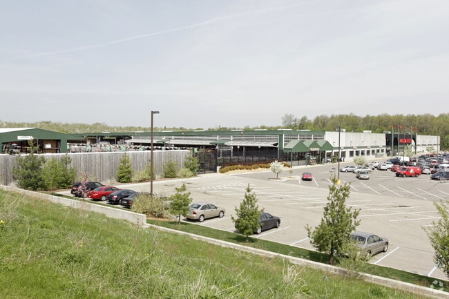
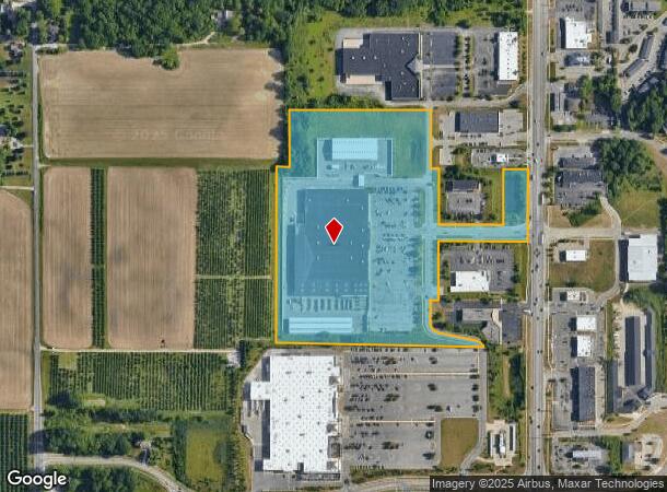
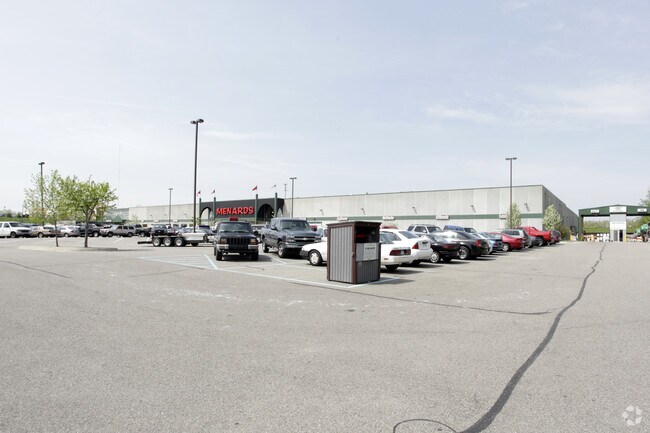
Property Record
4151 Alpine Ave Nw, Comstock Park, MI 49321
NEARBY LISTINGS FOR SALE OR LEASE
Property Detail
4151 Alpine Ave Nw
41-09-35-276-019
410935276019 PART OF NE 1/4 COM 388.12 FT N 0D 01M 09S E ALONG E SEC LINE & 318.48 FT N 88D 15M 11S W FROM E 1/4 COR TH NWLY
Storemultistory
Kent
X
Michigan
26081C0287D
25.79 AC
2024
Comstock/Alpine
2025
West Michigan
011403
Grand Rapids-Wyoming, MI
239,172 SF
DEMOGRAPHICS near 4151 Alpine Ave Nw
1 Mile
3 Mile
5 Mile
2024 Total Population
9,095
29,225
116,308
2029 Population
9,177
29,319
116,629
Pop Growth 2024-2029
+ 0.90%
+ 0.32%
+ 0.28%
Average Age
36
39
38
2024 Total Households
4,084
12,485
48,563
HH Growth 2024-2029
+ 0.93%
+ 0.35%
+ 0.33%
Median Household Inc
$49,351
$62,837
$66,222
Avg Household Size
2.20
2.30
2.30
2024 Avg HH Vehicles
2.00
2.00
2.00
Median Home Value
$218,264
$225,355
$222,079
Median Year Built
1986
1976
1965
Nearby Places
Map Layers
Map Styles
 Street
 Aerial
- Restaurants
- Banks
- Shops
- Fitness
- Groceries
PUBLIC TRANSPORTATION
COMMUTER RAIL
Grand Rapids Vernon J. Ehlers Station (Pere Marquette - Amtrak)
DRIVE
WALK
Distance
Grand Rapids Vernon J. Ehlers Station (Pere Marquette - Amtrak)
10 min
7.0 mi
AIRPORT
Gerald R Ford International
DRIVE
WALK
Distance
Gerald R Ford International
28 min
19.5 mi
Freight Ports
Port Milwaukee
DRIVE
WALK
Distance
Port Milwaukee
313 min
268.1 mi
Nearby Properties
Address
Land Use
TOTAL SIZE
Lot Size
Zoning
Address
Land Use
TOTAL SIZE
Lot Size
Zoning
537,080 SF
46.61 AC
RPUD - 2
Address
Land Use
TOTAL SIZE
Lot Size
Zoning
352,362 SF
61.33 AC
IPUD
Address
Land Use
TOTAL SIZE
Lot Size
Zoning
546,366 SF
28.40 AC
MH
Address
Land Use
TOTAL SIZE
Lot Size
Zoning
451,792 SF
32.60 AC
ARM - MULT
Address
Land Use
TOTAL SIZE
Lot Size
Zoning
455,639 SF
42.06 AC
MH
Address
Land Use
TOTAL SIZE
Lot Size
Zoning
340,744 SF
69.50 AC
RPUD - 2
Address
Land Use
TOTAL SIZE
Lot Size
Zoning
337,324 SF
10.15 AC
C-3
Address
Land Use
TOTAL SIZE
Lot Size
Zoning
169,898 SF
Address
Land Use
TOTAL SIZE
Lot Size
Zoning
Address
Land Use
TOTAL SIZE
Lot Size
Zoning
33.06 AC
R-3
Address
Land Use
TOTAL SIZE
Lot Size
Zoning
183,517 SF
44.93 AC
ML
Address
Land Use
TOTAL SIZE
Lot Size
Zoning
190,882 SF
30.17 AC
MP
Address
Land Use
TOTAL SIZE
Lot Size
Zoning
113,016 SF
33.69 AC
IPUD
Address
Land Use
TOTAL SIZE
Lot Size
Zoning
670,966 SF
40.67 AC
C-3
Address
Land Use
TOTAL SIZE
Lot Size
Zoning
Address
Land Use
TOTAL SIZE
Lot Size
Zoning
136,468 SF
13.34 AC
CPUD
Address
Land Use
TOTAL SIZE
Lot Size
Zoning
165,184 SF
14.85 AC
CPUD
Address
Land Use
TOTAL SIZE
Lot Size
Zoning
32.63 AC
R-3
Address
Land Use
TOTAL SIZE
Lot Size
Zoning
214,046 SF
31.31 AC
C-2
Address
Land Use
TOTAL SIZE
Lot Size
Zoning
267,000 SF
15.63 AC
IPUD
Address
Land Use
TOTAL SIZE
Lot Size
Zoning
118,085 SF
10.94 AC
CPUD
Address
Land Use
TOTAL SIZE
Lot Size
Zoning
332,315 SF
17.71 AC
MP
Address
Land Use
TOTAL SIZE
Lot Size
Zoning
Address
Land Use
TOTAL SIZE
Lot Size
Zoning
169,926 SF
8.52 AC
C-2
Address
Land Use
TOTAL SIZE
Lot Size
Zoning
Address
Land Use
TOTAL SIZE
Lot Size
Zoning
200,831 SF
11.69 AC
MH
Address
Land Use
TOTAL SIZE
Lot Size
Zoning
9.11 AC
R-3
Address
Land Use
TOTAL SIZE
Lot Size
Zoning
8.77 AC
R-3
Address
Land Use
TOTAL SIZE
Lot Size
Zoning
160,097 SF
11.58 AC
C-3
The World's #1 Commercial Real Estate Marketplace
Connect with us
© 2026 CoStar Group
The information above has been obtained from sources believed reliable. While we do not doubt its accuracy we have not verified it and make no guarantee, warranty or representation about it. It is your responsibility to independently confirm its accuracy and completeness. Any projections, opinions, assumptions, or estimates used are for example only and do not represent the current or future performance of the property. The value of this transaction to you depends on tax and other factors which should be evaluated by your tax, financial, and legal advisors. You and your advisors should conduct a careful, independent investigation of the property to determine to your satisfaction the suitability of the property for your needs.