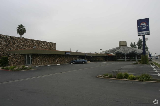
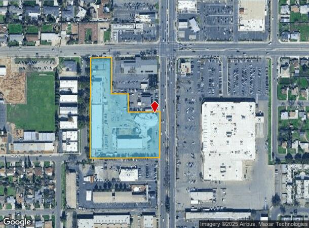
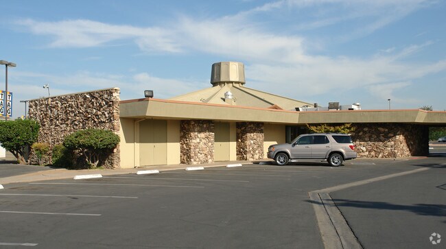
Property Record
4151 N Blackstone Ave, Fresno, CA 93726

NEARBY LISTINGS FOR SALE OR LEASE
Property Detail
4151 N Blackstone Ave
Fresno, CA
Del Mar Estates
434-092-15
4.09 AC IN LOTS 9 TO 18 TR 1539 DEL MAR ESTATES
Recreationalentertainmentgeneral
Fresno
X
California
06019C1570H
09/18
2025
4.09 AC
2025
South Blackstone
004901
Fresno
69,940 SF
DEMOGRAPHICS near 4151 N Blackstone Ave
1 Mile
3 Mile
5 Mile
2024 Total Population
17,137
179,809
415,739
2029 Population
17,509
183,245
423,695
Pop Growth 2024-2029
+ 2.17%
+ 1.91%
+ 1.91%
Average Age
36
36
36
2024 Total Households
5,820
62,889
142,013
HH Growth 2024-2029
+ 2.18%
+ 1.90%
+ 1.96%
Median Household Inc
$61,114
$51,319
$53,544
Avg Household Size
2.80
2.80
2.80
2024 Avg HH Vehicles
2.00
2.00
2.00
Median Home Value
$288,325
$271,988
$283,861
Median Year Built
1956
1963
1972
Nearby Places
Map Layers
Map Styles
 Street
 Aerial
- Restaurants
- Banks
- Shops
- Fitness
- Groceries
PUBLIC TRANSPORTATION
COMMUTER RAIL
DRIVE
WALK
Distance
7 min
4.6 mi
AIRPORT
Fresno Yosemite International
DRIVE
WALK
Distance
Fresno Yosemite International
10 min
5.4 mi
Nearby Properties
Address
Land Use
TOTAL SIZE
Lot Size
Zoning
Address
Land Use
TOTAL SIZE
Lot Size
Zoning
574,093 SF
25.54 AC
C3
Address
Land Use
TOTAL SIZE
Lot Size
Zoning
39,888 SF
23.72 AC
C3
Address
Land Use
TOTAL SIZE
Lot Size
Zoning
451,977 SF
24.16 AC
SPLIT
Address
Land Use
TOTAL SIZE
Lot Size
Zoning
81,545 SF
3.18 AC
CP
Address
Land Use
TOTAL SIZE
Lot Size
Zoning
234,370 SF
23 AC
SPLIT
Address
Land Use
TOTAL SIZE
Lot Size
Zoning
241,133 SF
13.61 AC
R3
Address
Land Use
TOTAL SIZE
Lot Size
Zoning
121,491 SF
4.52 AC
R3
Address
Land Use
TOTAL SIZE
Lot Size
Zoning
208,444 SF
11.75 AC
R3
Address
Land Use
TOTAL SIZE
Lot Size
Zoning
157,702 SF
4.61 AC
R2A
Address
Land Use
TOTAL SIZE
Lot Size
Zoning
110,456 SF
6.56 AC
RMX
Address
Land Use
TOTAL SIZE
Lot Size
Zoning
126,346 SF
5.49 AC
CP
Address
Land Use
TOTAL SIZE
Lot Size
Zoning
126,346 SF
5.31 AC
CP
Address
Land Use
TOTAL SIZE
Lot Size
Zoning
141,477 SF
5.45 AC
R4
Address
Land Use
TOTAL SIZE
Lot Size
Zoning
218,838 SF
19.06 AC
R2
Address
Land Use
TOTAL SIZE
Lot Size
Zoning
669,447 SF
0.01 AC
C3
Address
Land Use
TOTAL SIZE
Lot Size
Zoning
70,168 SF
4.97 AC
R3
Address
Land Use
TOTAL SIZE
Lot Size
Zoning
179,240 SF
12 AC
C3
Address
Land Use
TOTAL SIZE
Lot Size
Zoning
203,687 SF
10.63 AC
R3
Address
Land Use
TOTAL SIZE
Lot Size
Zoning
121,250 SF
9.51 AC
R3
Address
Land Use
TOTAL SIZE
Lot Size
Zoning
80,771 SF
7.47 AC
C2
Address
Land Use
TOTAL SIZE
Lot Size
Zoning
216,459 SF
16.28 AC
SPLIT
Address
Land Use
TOTAL SIZE
Lot Size
Zoning
81,754 SF
5.75 AC
C3
Address
Land Use
TOTAL SIZE
Lot Size
Zoning
110,341 SF
5.45 AC
R3
Address
Land Use
TOTAL SIZE
Lot Size
Zoning
88,859 SF
2.44 AC
CP
Address
Land Use
TOTAL SIZE
Lot Size
Zoning
220,564 SF
12.83 AC
SPLIT
Address
Land Use
TOTAL SIZE
Lot Size
Zoning
191,136 SF
12.12 AC
R2
Address
Land Use
TOTAL SIZE
Lot Size
Zoning
92,096 SF
0.01 AC
C3
Address
Land Use
TOTAL SIZE
Lot Size
Zoning
33,453 SF
13.18 AC
Address
Land Use
TOTAL SIZE
Lot Size
Zoning
108,288 SF
7.12 AC
R2A
Address
Land Use
TOTAL SIZE
Lot Size
Zoning
108,017 SF
2.91 AC
CM
The World's #1 Commercial Real Estate Marketplace
Connect with us
© 2026 CoStar Group
The information above has been obtained from sources believed reliable. While we do not doubt its accuracy we have not verified it and make no guarantee, warranty or representation about it. It is your responsibility to independently confirm its accuracy and completeness. Any projections, opinions, assumptions, or estimates used are for example only and do not represent the current or future performance of the property. The value of this transaction to you depends on tax and other factors which should be evaluated by your tax, financial, and legal advisors. You and your advisors should conduct a careful, independent investigation of the property to determine to your satisfaction the suitability of the property for your needs.