Property Record
4152 Highway 20, Trinity, AL 35673
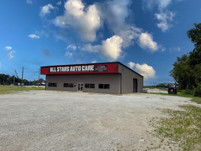

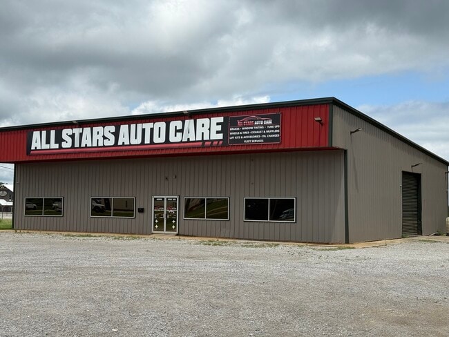
Property Detail
4152 Highway 20
Decatur, AL
THAT PART OF SE1/4 LYING N'LY OF HWY 72
02-03-07-0-000-004.000
MORGAN
Autorepair
Alabama
B and X Area of moderate flood hazard, usually the area between the limits of the 100-year and 500-year floods.
23
2025
0.80 AC
2024
Alabama North Area
979501
Other Market Areas
675 SF
NEARBY LISTINGS FOR SALE OR LEASE
DEMOGRAPHICS near 4152 Highway 20
1 mile
3 mile
5 mile
2025 Total Population
79
2,777
14,383
2030 Population
82
2,872
14,704
Pop Growth 2025-2030
+ 3.80%
+ 3.42%
+ 2.23%
Average Age
41
41
40
2025 Total Households
29
1,061
5,866
HH Growth 2025-2030
+ 3.45%
+ 3.49%
+ 2.22%
Median Household Inc
$111,250
$102,466
$73,489
Avg Household Size
2.70
2.60
2.40
2025 Avg HH Vehicles
3.00
3.00
2.00
Median Home Value
$283,333
$281,272
$242,630
Median Year Built
1991
1986
1987
Nearby Places
Map Layers
Map Styles
 Street
 Aerial
Transit
 Traffic
 Biking
Places
Listings with unknown addresses are not visible on the map
- Restaurants
- Banks
- Shops
- Fitness
- Groceries
PUBLIC TRANSPORTATION
AIRPORT
Huntsville International-Carl T Jones Field
Drive
Walk
Distance
Huntsville International-Carl T Jones Field
33 min
22.2 mi
SALE & LEASE HISTORY
LISTING DATE
SALE/LEASE

Jul 26, 2022
For Lease
Aug 15, 2025
For Lease
Nearby Properties
Address
Land Use
TOTAL SIZE
Lot Size
Zoning
Address
Land Use
TOTAL SIZE
Lot Size
Zoning
65,550 SF
173 AC
Address
Land Use
TOTAL SIZE
Lot Size
Zoning
800 SF
296 AC
Address
Land Use
TOTAL SIZE
Lot Size
Zoning
70,936 SF
37 AC
Address
Land Use
TOTAL SIZE
Lot Size
Zoning
207 SF
90 AC
Address
Land Use
TOTAL SIZE
Lot Size
Zoning
12,612 SF
42 AC
Address
Land Use
TOTAL SIZE
Lot Size
Zoning
85,080 SF
21 AC
Address
Land Use
TOTAL SIZE
Lot Size
Zoning
49,762 SF
2.60 AC
Address
Land Use
TOTAL SIZE
Lot Size
Zoning
132,359 SF
Address
Land Use
TOTAL SIZE
Lot Size
Zoning
81,916 SF
45 AC
Address
Land Use
TOTAL SIZE
Lot Size
Zoning
124,209 SF
26 AC
Address
Land Use
TOTAL SIZE
Lot Size
Zoning
32,947 SF
567 AC
Address
Land Use
TOTAL SIZE
Lot Size
Zoning
36,304 SF
97 AC
Address
Land Use
TOTAL SIZE
Lot Size
Zoning
287,220 SF
76 AC
Address
Land Use
TOTAL SIZE
Lot Size
Zoning
9,332 SF
Address
Land Use
TOTAL SIZE
Lot Size
Zoning
4.25 AC
Address
Land Use
TOTAL SIZE
Lot Size
Zoning
83,624 SF
28 AC
Address
Land Use
TOTAL SIZE
Lot Size
Zoning
154,000 SF
60 AC
Address
Land Use
TOTAL SIZE
Lot Size
Zoning
33,520 SF
Address
Land Use
TOTAL SIZE
Lot Size
Zoning
261,328 SF
67 AC
Address
Land Use
TOTAL SIZE
Lot Size
Zoning
85,080 SF
21 AC
Address
Land Use
TOTAL SIZE
Lot Size
Zoning
100,000 SF
1 AC
Address
Land Use
TOTAL SIZE
Lot Size
Zoning
62,709 SF
291 AC
Address
Land Use
TOTAL SIZE
Lot Size
Zoning
175,664 SF
13 AC
Address
Land Use
TOTAL SIZE
Lot Size
Zoning
3,466 SF
41 AC
Address
Land Use
TOTAL SIZE
Lot Size
Zoning
10,884 SF
0.90 AC
Address
Land Use
TOTAL SIZE
Lot Size
Zoning
40,008 SF
19.90 AC
Address
Land Use
TOTAL SIZE
Lot Size
Zoning
153,720 SF
30 AC
Address
Land Use
TOTAL SIZE
Lot Size
Zoning
129,000 SF
39 AC
Address
Land Use
TOTAL SIZE
Lot Size
Zoning
33,397 SF
Address
Land Use
TOTAL SIZE
Lot Size
Zoning
4,931 SF
27 AC
The World's #1 Commercial Real Estate Marketplace
Connect with us
© 2026 CoStar Group
The information above has been obtained from sources believed reliable. While we do not doubt its accuracy we have not verified it and make no guarantee, warranty or representation about it. It is your responsibility to independently confirm its accuracy and completeness. Any projections, opinions, assumptions, or estimates used are for example only and do not represent the current or future performance of the property. The value of this transaction to you depends on tax and other factors which should be evaluated by your tax, financial, and legal advisors. You and your advisors should conduct a careful, independent investigation of the property to determine to your satisfaction the suitability of the property for your needs.