Property Record
4153 Spurr Rd, Lexington, KY 40511
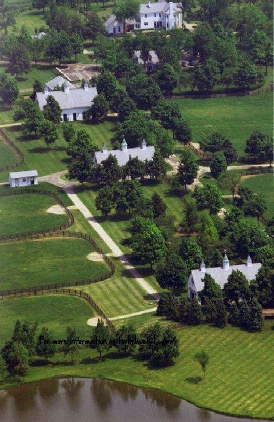

Property Detail
4153 Spurr Rd
26558100
BOOK: 3713 PAGE: 606
Livestock
FAYETTE
A-R
Kentucky
AE The base floodplain where base flood elevations are provided. AE Zones are now used on new format FIRMs instead of A1-A30 Zones.
1-2
2025
269.58 AC
2025
West Lexington/Fayette
003701
Lexington/Fayette
6,220 SF
Lexington-Fayette, KY
NEARBY LISTINGS FOR SALE OR LEASE
-
-
View all Lexington listings for sale on LoopNet.com
DEMOGRAPHICS near 4153 Spurr Rd
1 mile
3 mile
5 mile
2025 Total Population
705
21,552
45,893
2030 Population
701
22,479
47,948
Pop Growth 2025-2030
(0.57%)
+ 4.30%
+ 4.48%
Average Age
47
37
37
2025 Total Households
39
7,393
17,378
HH Growth 2025-2030
(2.56%)
+ 4.87%
+ 4.86%
Median Household Inc
$132,353
$92,517
$79,090
Avg Household Size
2.50
2.60
2.50
2025 Avg HH Vehicles
3.00
2.00
2.00
Median Home Value
$1,131,250
$272,099
$248,363
Median Year Built
1994
2006
2000
Nearby Places
Map Layers
Map Styles
 Street
 Aerial
Layers
 Traffic
 Biking
Places
Listings with unknown addresses are not visible on the map
- Restaurants
- Banks
- Shops
- Fitness
- Groceries
PUBLIC TRANSPORTATION
AIRPORT
Blue Grass
Drive
Walk
Distance
Blue Grass
23 min
12.5 mi
Freight Ports
Port of Toledo
Drive
Walk
Distance
Port of Toledo
337 min
285.9 mi
Nearby Properties
Address
Land Use
TOTAL SIZE
Lot Size
Zoning
Address
Land Use
TOTAL SIZE
Lot Size
Zoning
6,173 SF
301.57 AC
A-R
Address
Land Use
TOTAL SIZE
Lot Size
Zoning
Address
Land Use
TOTAL SIZE
Lot Size
Zoning
6,462 SF
332.36 AC
I-1
Address
Land Use
TOTAL SIZE
Lot Size
Zoning
16.93 AC
R-3
Address
Land Use
TOTAL SIZE
Lot Size
Zoning
9.05 AC
R-3
Address
Land Use
TOTAL SIZE
Lot Size
Zoning
76,701 SF
14.98 AC
R-3
Address
Land Use
TOTAL SIZE
Lot Size
Zoning
7.01 AC
R-3
Address
Land Use
TOTAL SIZE
Lot Size
Zoning
29,622 SF
8.30 AC
R-3
Address
Land Use
TOTAL SIZE
Lot Size
Zoning
154,374 SF
19 AC
I-1
Address
Land Use
TOTAL SIZE
Lot Size
Zoning
9.72 AC
R-4
Address
Land Use
TOTAL SIZE
Lot Size
Zoning
48,814 SF
10.99 AC
A-U
Address
Land Use
TOTAL SIZE
Lot Size
Zoning
5,140 SF
670.33 AC
A-R
Address
Land Use
TOTAL SIZE
Lot Size
Zoning
19,012 SF
82.28 AC
A-R
Address
Land Use
TOTAL SIZE
Lot Size
Zoning
5,830 SF
360.11 AC
A-R
Address
Land Use
TOTAL SIZE
Lot Size
Zoning
9.68 AC
B-4
Address
Land Use
TOTAL SIZE
Lot Size
Zoning
165,600 SF
10 AC
I-1
Address
Land Use
TOTAL SIZE
Lot Size
Zoning
105,736 SF
10.31 AC
I-1
Address
Land Use
TOTAL SIZE
Lot Size
Zoning
9,045 SF
237.17 AC
A-R
Address
Land Use
TOTAL SIZE
Lot Size
Zoning
1,628 SF
42.25 AC
A-R
Address
Land Use
TOTAL SIZE
Lot Size
Zoning
2,006 SF
418.30 AC
A-R
Address
Land Use
TOTAL SIZE
Lot Size
Zoning
5,224 SF
120.80 AC
A-R
Address
Land Use
TOTAL SIZE
Lot Size
Zoning
39,866 SF
100.14 AC
A-R
Address
Land Use
TOTAL SIZE
Lot Size
Zoning
1,792 SF
35.71 AC
A-R
Address
Land Use
TOTAL SIZE
Lot Size
Zoning
72,310 SF
5.72 AC
I-1
Address
Land Use
TOTAL SIZE
Lot Size
Zoning
7.08 AC
R-3
Address
Land Use
TOTAL SIZE
Lot Size
Zoning
35,367 SF
10 AC
Address
Land Use
TOTAL SIZE
Lot Size
Zoning
2,546 SF
194.13 AC
A-R
Address
Land Use
TOTAL SIZE
Lot Size
Zoning
9,068 SF
146.52 AC
A-R
Address
Land Use
TOTAL SIZE
Lot Size
Zoning
3,320 SF
147.88 AC
A-R
The World's #1 Commercial Real Estate Marketplace
Connect with us
© 2026 CoStar Group
The information above has been obtained from sources believed reliable. While we do not doubt its accuracy we have not verified it and make no guarantee, warranty or representation about it. It is your responsibility to independently confirm its accuracy and completeness. Any projections, opinions, assumptions, or estimates used are for example only and do not represent the current or future performance of the property. The value of this transaction to you depends on tax and other factors which should be evaluated by your tax, financial, and legal advisors. You and your advisors should conduct a careful, independent investigation of the property to determine to your satisfaction the suitability of the property for your needs.