Property Record
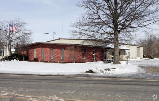
4155 Martindale Rd Ne, Canton, OH 44705


Property Detail
4155 Martindale Rd Ne
05218195
27 NE .79A
Warehouse
Stark
C and X Area of minimal flood hazard, usually depicted on FIRMs as above the 500-year flood level.
Ohio
0
0.79 AC
2025
Stark County
712202
Cleveland
6,960 SF
Canton-Massillon, OH
NEARBY LISTINGS FOR SALE OR LEASE
DEMOGRAPHICS near 4155 Martindale Rd Ne
1 mile
3 mile
5 mile
2025 Total Population
6,436
64,742
140,343
2030 Population
6,403
64,649
140,068
Pop Growth 2025-2030
(0.51%)
(0.14%)
(0.20%)
Average Age
44
41
41
2025 Total Households
2,782
27,067
59,891
HH Growth 2025-2030
(0.54%)
(0.20%)
(0.24%)
Median Household Inc
$69,122
$55,537
$55,568
Avg Household Size
2.30
2.20
2.20
2025 Avg HH Vehicles
2.00
2.00
2.00
Median Home Value
$189,243
$163,275
$167,212
Median Year Built
1965
1958
1959
Nearby Places
Map Layers
Map Styles
 Street
 Aerial
Layers
 Traffic
 Biking
Places
Listings with unknown addresses are not visible on the map
- Restaurants
- Banks
- Shops
- Fitness
- Groceries
PUBLIC TRANSPORTATION
AIRPORT
Akron-Canton Regional
Drive
Walk
Distance
Akron-Canton Regional
17 min
10.6 mi
SALE & LEASE HISTORY
LISTING DATE
SALE/LEASE

Nov 06, 2025
For Lease
Nearby Properties
Address
Land Use
TOTAL SIZE
Lot Size
Zoning
Address
Land Use
TOTAL SIZE
Lot Size
Zoning
730,347 SF
55.42 AC
Address
Land Use
TOTAL SIZE
Lot Size
Zoning
365,452 SF
113.92 AC
Address
Land Use
TOTAL SIZE
Lot Size
Zoning
91.83 AC
Address
Land Use
TOTAL SIZE
Lot Size
Zoning
272,327 SF
23.62 AC
Address
Land Use
TOTAL SIZE
Lot Size
Zoning
272,888 SF
27.61 AC
Address
Land Use
TOTAL SIZE
Lot Size
Zoning
327,119 SF
50.74 AC
Address
Land Use
TOTAL SIZE
Lot Size
Zoning
140,060 SF
27.57 AC
Address
Land Use
TOTAL SIZE
Lot Size
Zoning
1,069,826 SF
158.31 AC
Address
Land Use
TOTAL SIZE
Lot Size
Zoning
118,889 SF
19.77 AC
Address
Land Use
TOTAL SIZE
Lot Size
Zoning
116,904 SF
55.51 AC
Address
Land Use
TOTAL SIZE
Lot Size
Zoning
476,634 SF
15.08 AC
Address
Land Use
TOTAL SIZE
Lot Size
Zoning
195,551 SF
37.77 AC
Address
Land Use
TOTAL SIZE
Lot Size
Zoning
316,099 SF
8.47 AC
Address
Land Use
TOTAL SIZE
Lot Size
Zoning
93,932 SF
11.31 AC
Address
Land Use
TOTAL SIZE
Lot Size
Zoning
202,684 SF
40.97 AC
Address
Land Use
TOTAL SIZE
Lot Size
Zoning
82,950 SF
Address
Land Use
TOTAL SIZE
Lot Size
Zoning
1,096,089 SF
144.96 AC
Address
Land Use
TOTAL SIZE
Lot Size
Zoning
93,216 SF
4.93 AC
Address
Land Use
TOTAL SIZE
Lot Size
Zoning
180,088 SF
71.80 AC
Address
Land Use
TOTAL SIZE
Lot Size
Zoning
69,656 SF
23.70 AC
Address
Land Use
TOTAL SIZE
Lot Size
Zoning
153,834 SF
20.21 AC
Address
Land Use
TOTAL SIZE
Lot Size
Zoning
145,719 SF
43.60 AC
Address
Land Use
TOTAL SIZE
Lot Size
Zoning
217,695 SF
19.46 AC
Address
Land Use
TOTAL SIZE
Lot Size
Zoning
135,840 SF
21 AC
Address
Land Use
TOTAL SIZE
Lot Size
Zoning
58,021 SF
13.25 AC
Address
Land Use
TOTAL SIZE
Lot Size
Zoning
52,876 SF
4.96 AC
Address
Land Use
TOTAL SIZE
Lot Size
Zoning
118,052 SF
12.52 AC
Address
Land Use
TOTAL SIZE
Lot Size
Zoning
45,482 SF
1.01 AC
Address
Land Use
TOTAL SIZE
Lot Size
Zoning
329,666 SF
4.62 AC
Address
Land Use
TOTAL SIZE
Lot Size
Zoning
217,634 SF
11.85 AC
The World's #1 Commercial Real Estate Marketplace
Connect with us
© 2026 CoStar Group
The information above has been obtained from sources believed reliable. While we do not doubt its accuracy we have not verified it and make no guarantee, warranty or representation about it. It is your responsibility to independently confirm its accuracy and completeness. Any projections, opinions, assumptions, or estimates used are for example only and do not represent the current or future performance of the property. The value of this transaction to you depends on tax and other factors which should be evaluated by your tax, financial, and legal advisors. You and your advisors should conduct a careful, independent investigation of the property to determine to your satisfaction the suitability of the property for your needs.