Property Record
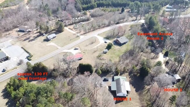
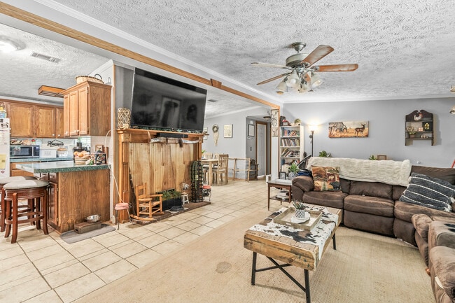
4155 Slanting Bridge Rd, Sherrills Ford, NC 28673

This Property Is For Sale
NEARBY LISTINGS FOR SALE OR LEASE
Property Detail
4155 Slanting Bridge Rd
Hickory-Lenoir-Morganton, NC
Plat Of 4145 Slanting Bridge Road
4607048127250000
Catawba
Modularprefabricatedhomes
North Carolina
X
2.54 AC
3710460700J
Catawba County
1,568 SF
Charlotte
DEMOGRAPHICS near 4155 Slanting Bridge Rd
1 Mile
3 Mile
5 Mile
2024 Total Population
2,477
11,729
35,931
2029 Population
2,748
12,985
40,704
Pop Growth 2024-2029
+ 10.94%
+ 10.71%
+ 13.28%
Average Age
47
45
43
2024 Total Households
1,059
4,813
13,906
HH Growth 2024-2029
+ 11.05%
+ 10.66%
+ 13.16%
Median Household Inc
$101,124
$100,547
$111,006
Avg Household Size
2.30
2.40
2.60
2024 Avg HH Vehicles
2.00
2.00
2.00
Median Home Value
$420,183
$428,851
$481,568
Median Year Built
2003
2000
2001
Nearby Places
Map Layers
Map Styles
 Street
 Aerial
- Restaurants
- Banks
- Shops
- Fitness
- Groceries
PUBLIC TRANSPORTATION
AIRPORT
Charlotte/Douglas International
DRIVE
WALK
Distance
Charlotte/Douglas International
50 min
31.2 mi
Concord-Padgett Regional
DRIVE
WALK
Distance
Concord-Padgett Regional
45 min
33.0 mi
Freight Ports
North Charleston Terminal
DRIVE
WALK
Distance
North Charleston Terminal
261 min
227.1 mi
Nearby Properties
Address
Land Use
TOTAL SIZE
Lot Size
Zoning
Address
Land Use
TOTAL SIZE
Lot Size
Zoning
31,198 SF
26.01 AC
PD-CD
Address
Land Use
TOTAL SIZE
Lot Size
Zoning
1,288 SF
16.04 AC
PD-CD
Address
Land Use
TOTAL SIZE
Lot Size
Zoning
1,709.40 AC
GI
Address
Land Use
TOTAL SIZE
Lot Size
Zoning
60,860 SF
9.81 AC
PD-CD
Address
Land Use
TOTAL SIZE
Lot Size
Zoning
79,137 SF
6.34 AC
HC
Address
Land Use
TOTAL SIZE
Lot Size
Zoning
80,181 SF
17.50 AC
R-20
Address
Land Use
TOTAL SIZE
Lot Size
Zoning
1,912 SF
31.99 AC
HC
Address
Land Use
TOTAL SIZE
Lot Size
Zoning
20,595 SF
2.65 AC
PD-CD
Address
Land Use
TOTAL SIZE
Lot Size
Zoning
1,850 SF
36.60 AC
PD
Address
Land Use
TOTAL SIZE
Lot Size
Zoning
33,342 SF
9.79 AC
RC
Address
Land Use
TOTAL SIZE
Lot Size
Zoning
1,500 SF
11.02 AC
PD
Address
Land Use
TOTAL SIZE
Lot Size
Zoning
2,000 SF
33.70 AC
R-30
Address
Land Use
TOTAL SIZE
Lot Size
Zoning
18,316 SF
3.61 AC
PD-CD
Address
Land Use
TOTAL SIZE
Lot Size
Zoning
37,999 SF
3.41 AC
HC
Address
Land Use
TOTAL SIZE
Lot Size
Zoning
6,889 SF
1.75 AC
PD-CD
Address
Land Use
TOTAL SIZE
Lot Size
Zoning
4,329 SF
1.43 AC
PD-CD
Address
Land Use
TOTAL SIZE
Lot Size
Zoning
12,352 SF
4.55 AC
HC
Address
Land Use
TOTAL SIZE
Lot Size
Zoning
5,290 SF
1.21 AC
PD-CD
Address
Land Use
TOTAL SIZE
Lot Size
Zoning
8.04 AC
R-20
Address
Land Use
TOTAL SIZE
Lot Size
Zoning
10,883 SF
2.50 AC
PD
Address
Land Use
TOTAL SIZE
Lot Size
Zoning
9,000 SF
6.04 AC
PD
Address
Land Use
TOTAL SIZE
Lot Size
Zoning
5,090 SF
1.01 AC
PD-CD
Address
Land Use
TOTAL SIZE
Lot Size
Zoning
4.29 AC
R-SF
Address
Land Use
TOTAL SIZE
Lot Size
Zoning
13,876 SF
3.74 AC
R-30
Address
Land Use
TOTAL SIZE
Lot Size
Zoning
12,717 SF
1.47 AC
PD-CD
Address
Land Use
TOTAL SIZE
Lot Size
Zoning
5,307 SF
0.98 AC
R-30
Address
Land Use
TOTAL SIZE
Lot Size
Zoning
13.60 AC
PD-CD
Address
Land Use
TOTAL SIZE
Lot Size
Zoning
29,070 SF
5.36 AC
PD
Address
Land Use
TOTAL SIZE
Lot Size
Zoning
7,569 SF
1.53 AC
PD-CD
Address
Land Use
TOTAL SIZE
Lot Size
Zoning
19,692 SF
3.74 AC
PD
The World's #1 Commercial Real Estate Marketplace
Connect with us
© 2025 CoStar Group
The information above has been obtained from sources believed reliable. While we do not doubt its accuracy we have not verified it and make no guarantee, warranty or representation about it. It is your responsibility to independently confirm its accuracy and completeness. Any projections, opinions, assumptions, or estimates used are for example only and do not represent the current or future performance of the property. The value of this transaction to you depends on tax and other factors which should be evaluated by your tax, financial, and legal advisors. You and your advisors should conduct a careful, independent investigation of the property to determine to your satisfaction the suitability of the property for your needs.