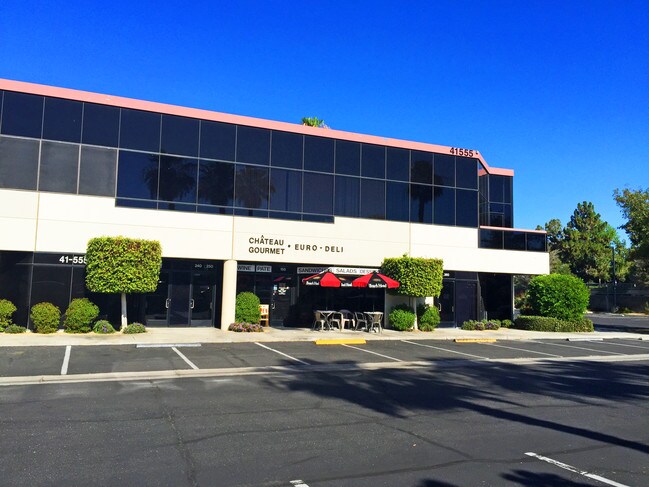
Property Record
41555 Cook St, Palm Desert, CA 92211
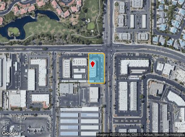
NEARBY LISTINGS FOR SALE OR LEASE
Property Detail
41555 Cook St
624-290-055
Parcel Map 37137
Officebuilding
1.25 ACRES M/L IN PAR 3 PM 241/070
X
Riverside
06065C2226H
California
2024
1.25 AC
2025
Coachella Valley
044930
Inland Empire (California)
21,273 SF
Riverside-San Bernardino-Ontario, CA
DEMOGRAPHICS near 41555 Cook St
1 Mile
3 Mile
5 Mile
2024 Total Population
7,480
68,971
130,753
2029 Population
8,314
76,402
144,569
Pop Growth 2024-2029
+ 11.15%
+ 10.77%
+ 10.57%
Average Age
50
52
53
2024 Total Households
3,303
32,844
62,295
HH Growth 2024-2029
+ 11.20%
+ 10.66%
+ 10.45%
Median Household Inc
$101,305
$77,318
$82,728
Avg Household Size
2.10
2.00
2.00
2024 Avg HH Vehicles
2.00
2.00
2.00
Median Home Value
$609,656
$574,786
$606,609
Median Year Built
1989
1986
1987
Nearby Places
Map Layers
Map Styles
 Street
 Aerial
- Restaurants
- Banks
- Shops
- Fitness
- Groceries
PUBLIC TRANSPORTATION
AIRPORT
Palm Springs International
DRIVE
WALK
Distance
Palm Springs International
21 min
14.7 mi
SALE & LEASE HISTORY
LISTING DATE
SALE/LEASE

Sep 24, 2016
For Lease
Nov 15, 2017
For Lease
Aug 30, 2017
For Lease
Nearby Properties
Address
Land Use
TOTAL SIZE
Lot Size
Zoning
Address
Land Use
TOTAL SIZE
Lot Size
Zoning
34,292 SF
34.67 AC
R112M
Address
Land Use
TOTAL SIZE
Lot Size
Zoning
52,981 SF
16.98 AC
Address
Land Use
TOTAL SIZE
Lot Size
Zoning
400,240 SF
9.40 AC
PR060
Address
Land Use
TOTAL SIZE
Lot Size
Zoning
2,169 SF
21.30 AC
Address
Land Use
TOTAL SIZE
Lot Size
Zoning
42,225 SF
20.83 AC
HW
Address
Land Use
TOTAL SIZE
Lot Size
Zoning
488,725 SF
24.17 AC
C1
Address
Land Use
TOTAL SIZE
Lot Size
Zoning
445,569 SF
17.55 AC
PUDC
Address
Land Use
TOTAL SIZE
Lot Size
Zoning
217,730 SF
8.64 AC
R1010
Address
Land Use
TOTAL SIZE
Lot Size
Zoning
99,290 SF
14.97 AC
Address
Land Use
TOTAL SIZE
Lot Size
Zoning
15.90 AC
Address
Land Use
TOTAL SIZE
Lot Size
Zoning
32,576 SF
19.40 AC
CBOOK
Address
Land Use
TOTAL SIZE
Lot Size
Zoning
306,484 SF
17.64 AC
OS
Address
Land Use
TOTAL SIZE
Lot Size
Zoning
164,751 SF
8.25 AC
Address
Land Use
TOTAL SIZE
Lot Size
Zoning
103,940 SF
4.56 AC
Address
Land Use
TOTAL SIZE
Lot Size
Zoning
214,678 SF
6.43 AC
Address
Land Use
TOTAL SIZE
Lot Size
Zoning
146,996 SF
6.75 AC
R1010
Address
Land Use
TOTAL SIZE
Lot Size
Zoning
166,750 SF
10.69 AC
PR-5
Address
Land Use
TOTAL SIZE
Lot Size
Zoning
284,977 SF
23.95 AC
Address
Land Use
TOTAL SIZE
Lot Size
Zoning
136,875 SF
8.87 AC
O
Address
Land Use
TOTAL SIZE
Lot Size
Zoning
150,818 SF
2.02 AC
R3
Address
Land Use
TOTAL SIZE
Lot Size
Zoning
58,823 SF
5.87 AC
C-N
Address
Land Use
TOTAL SIZE
Lot Size
Zoning
41,533 SF
1.38 AC
C1SP
Address
Land Use
TOTAL SIZE
Lot Size
Zoning
209,000 SF
7.12 AC
Address
Land Use
TOTAL SIZE
Lot Size
Zoning
82,028 SF
8.32 AC
PR6
Address
Land Use
TOTAL SIZE
Lot Size
Zoning
131,298 SF
10.06 AC
CPS
Address
Land Use
TOTAL SIZE
Lot Size
Zoning
65,000 SF
9.51 AC
Address
Land Use
TOTAL SIZE
Lot Size
Zoning
86,064 SF
6.95 AC
Address
Land Use
TOTAL SIZE
Lot Size
Zoning
46,282 SF
11.90 AC
Address
Land Use
TOTAL SIZE
Lot Size
Zoning
50,318 SF
0.87 AC
PR060
Address
Land Use
TOTAL SIZE
Lot Size
Zoning
61,100 SF
5.82 AC
The World's #1 Commercial Real Estate Marketplace
Connect with us
© 2025 CoStar Group
The information above has been obtained from sources believed reliable. While we do not doubt its accuracy we have not verified it and make no guarantee, warranty or representation about it. It is your responsibility to independently confirm its accuracy and completeness. Any projections, opinions, assumptions, or estimates used are for example only and do not represent the current or future performance of the property. The value of this transaction to you depends on tax and other factors which should be evaluated by your tax, financial, and legal advisors. You and your advisors should conduct a careful, independent investigation of the property to determine to your satisfaction the suitability of the property for your needs.