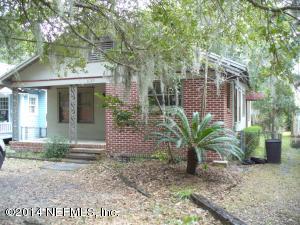
Property Record
4159 Oxford Ave, Jacksonville, FL 32210


Save to a Folder
{{folder.Name}}
{{folder.ListingIds.length}} Properties
{{folder.ListingIds.length}} Property
Create a New Folder
Property Detail
4159 Oxford Ave
101556-0000
3-40 42-3S-26E .14 ORTEGA PT LOT 5 RECD O/R 18470-791 BLK 27, PT CLD RW ORD 86-494-270
Officebuilding
Duval
CN
Florida
B and X Area of moderate flood hazard, usually the area between the limits of the 100-year and 500-year floods.
5
2025
0.13 AC
2026
Riverside
002400
Jacksonville (Florida)
1,380 SF
Jacksonville, FL
NEARBY LISTINGS FOR SALE OR LEASE
DEMOGRAPHICS near 4159 Oxford Ave
1 mile
3 mile
5 mile
2025 Total Population
4,166
62,133
184,989
2030 Population
4,373
65,948
197,031
Pop Growth 2025-2030
+ 4.97%
+ 6.14%
+ 6.51%
Average Age
43
40
39
2025 Total Households
1,713
27,642
77,477
HH Growth 2025-2030
+ 5.25%
+ 6.47%
+ 6.96%
Median Household Inc
$144,015
$68,832
$60,343
Avg Household Size
2.40
2.20
2.30
2025 Avg HH Vehicles
2.00
2.00
1.00
Median Home Value
$581,594
$347,497
$272,701
Median Year Built
1954
1958
1968
Nearby Places
Map Layers
Map Styles
 Street
 Aerial
Layers
 Traffic
 Biking
Places
Listings with unknown addresses are not visible on the map
- Restaurants
- Banks
- Shops
- Fitness
- Groceries
PUBLIC TRANSPORTATION
COMMUTER RAIL
Drive
Walk
Distance
19 min
9.2 mi
AIRPORT
Jacksonville International
Drive
Walk
Distance
Jacksonville International
34 min
21.2 mi
Freight Ports
Jacksonville Port
Drive
Walk
Distance
Jacksonville Port
21 min
11.7 mi
SALE & LEASE HISTORY
LISTING DATE
SALE/LEASE

Feb 27, 2018
For Sale
Nearby Properties
Address
Land Use
TOTAL SIZE
Lot Size
Zoning
Address
Land Use
TOTAL SIZE
Lot Size
Zoning
629,459 SF
10.33 AC
PUD
Address
Land Use
TOTAL SIZE
Lot Size
Zoning
290,975 SF
4.49 AC
PUD
Address
Land Use
TOTAL SIZE
Lot Size
Zoning
184,052 SF
21.69 AC
CCG-1
Address
Land Use
TOTAL SIZE
Lot Size
Zoning
291,338 SF
37 AC
PBF-1
Address
Land Use
TOTAL SIZE
Lot Size
Zoning
147,066 SF
3.30 AC
PUD
Address
Land Use
TOTAL SIZE
Lot Size
Zoning
416,674 SF
18.38 AC
RMD-D
Address
Land Use
TOTAL SIZE
Lot Size
Zoning
203,724 SF
14.71 AC
RMD-D
Address
Land Use
TOTAL SIZE
Lot Size
Zoning
129,506 SF
21.68 AC
CCG-2
Address
Land Use
TOTAL SIZE
Lot Size
Zoning
224,893 SF
13.51 AC
RMD-D
Address
Land Use
TOTAL SIZE
Lot Size
Zoning
309,137 SF
20.09 AC
RMD-D
Address
Land Use
TOTAL SIZE
Lot Size
Zoning
196,790 SF
12.62 AC
RMD-D
Address
Land Use
TOTAL SIZE
Lot Size
Zoning
276,281 SF
11.72 AC
RMD-D
Address
Land Use
TOTAL SIZE
Lot Size
Zoning
32,663 SF
2.56 AC
PUD
Address
Land Use
TOTAL SIZE
Lot Size
Zoning
206,513 SF
9.83 AC
RMD-D
Address
Land Use
TOTAL SIZE
Lot Size
Zoning
169,370 SF
10.87 AC
RMD-D
Address
Land Use
TOTAL SIZE
Lot Size
Zoning
231,044 SF
10.94 AC
RMD-D
Address
Land Use
TOTAL SIZE
Lot Size
Zoning
70,460 SF
1.66 AC
CCG-2
Address
Land Use
TOTAL SIZE
Lot Size
Zoning
115,041 SF
3.39 AC
PUD
Address
Land Use
TOTAL SIZE
Lot Size
Zoning
152,768 SF
9.66 AC
RMD-D
Address
Land Use
TOTAL SIZE
Lot Size
Zoning
46,139 SF
2.77 AC
PUD
Address
Land Use
TOTAL SIZE
Lot Size
Zoning
159,337 SF
11.09 AC
RMD-D
Address
Land Use
TOTAL SIZE
Lot Size
Zoning
125,246 SF
2.84 AC
PUD
Address
Land Use
TOTAL SIZE
Lot Size
Zoning
187,612 SF
20.16 AC
PUD
Address
Land Use
TOTAL SIZE
Lot Size
Zoning
85,238 SF
3.90 AC
CCG-2
Address
Land Use
TOTAL SIZE
Lot Size
Zoning
99,466 SF
3.61 AC
PUD
Address
Land Use
TOTAL SIZE
Lot Size
Zoning
453,651 SF
14.53 AC
CRO
Address
Land Use
TOTAL SIZE
Lot Size
Zoning
31,820 SF
0.35 AC
PUD
Address
Land Use
TOTAL SIZE
Lot Size
Zoning
59,810 SF
11.90 AC
CCG-2
Address
Land Use
TOTAL SIZE
Lot Size
Zoning
107,045 SF
9 AC
RMD-D
Address
Land Use
TOTAL SIZE
Lot Size
Zoning
59,871 SF
3.55 AC
CCG-2
The World's #1 Commercial Real Estate Marketplace
Connect with us
© 2026 CoStar Group
The information above has been obtained from sources believed reliable. While we do not doubt its accuracy we have not verified it and make no guarantee, warranty or representation about it. It is your responsibility to independently confirm its accuracy and completeness. Any projections, opinions, assumptions, or estimates used are for example only and do not represent the current or future performance of the property. The value of this transaction to you depends on tax and other factors which should be evaluated by your tax, financial, and legal advisors. You and your advisors should conduct a careful, independent investigation of the property to determine to your satisfaction the suitability of the property for your needs.