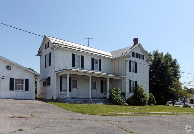
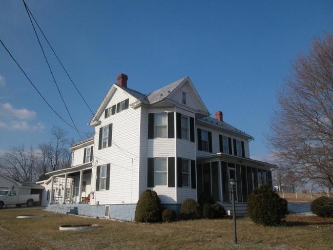
Property Record
4159 Williamsport Pike, Martinsburg, WV 25404
NEARBY LISTINGS FOR SALE OR LEASE
-
-
View all Martinsburg listings for sale on LoopNet.com
Property Detail
4159 Williamsport Pike
Hagerstown-Martinsburg, MD-WV
Berkeley
02-17-00010000
West Virginia
Residentialacreage
2.86 AC
X
Berkeley County
24043C0275D
Washington, DC
1,972 SF
DEMOGRAPHICS near 4159 Williamsport Pike
1 Mile
3 Mile
5 Mile
2024 Total Population
2,597
16,582
50,545
2029 Population
2,974
19,196
58,191
Pop Growth 2024-2029
+ 14.52%
+ 15.76%
+ 15.13%
Average Age
40
39
39
2024 Total Households
1,032
6,452
19,570
HH Growth 2024-2029
+ 15.21%
+ 16.31%
+ 15.70%
Median Household Inc
$70,723
$73,788
$67,727
Avg Household Size
2.50
2.50
2.50
2024 Avg HH Vehicles
2.00
2.00
2.00
Median Home Value
$244,859
$232,001
$226,623
Median Year Built
2003
2002
1999
Nearby Places
Map Layers
Map Styles
 Street
 Aerial
- Restaurants
- Banks
- Shops
- Fitness
- Groceries
PUBLIC TRANSPORTATION
COMMUTER RAIL
Martinsburg W Va Marc (BRUNSWICK - WASHINGTON - Maryland Transit Administration)
DRIVE
WALK
Distance
Martinsburg W Va Marc (BRUNSWICK - WASHINGTON - Maryland Transit Administration)
8 min
5.4 mi
Martinsburg (Brunswick Line - Maryland Area Regional Commuter Trains (The MARC))
DRIVE
WALK
Distance
Martinsburg (Brunswick Line - Maryland Area Regional Commuter Trains (The MARC))
9 min
5.7 mi
AIRPORT
Hagerstown Regional/Richard A Henson Field
DRIVE
WALK
Distance
Hagerstown Regional/Richard A Henson Field
24 min
18.4 mi
Freight Ports
Port of Baltimore
DRIVE
WALK
Distance
Port of Baltimore
103 min
87.6 mi
Nearby Properties
Address
Land Use
TOTAL SIZE
Lot Size
Zoning
Address
Land Use
TOTAL SIZE
Lot Size
Zoning
91.77 AC
Address
Land Use
TOTAL SIZE
Lot Size
Zoning
Address
Land Use
TOTAL SIZE
Lot Size
Zoning
47.92 AC
Address
Land Use
TOTAL SIZE
Lot Size
Zoning
139.91 AC
Address
Land Use
TOTAL SIZE
Lot Size
Zoning
Address
Land Use
TOTAL SIZE
Lot Size
Zoning
25.69 AC
Address
Land Use
TOTAL SIZE
Lot Size
Zoning
104.75 AC
Address
Land Use
TOTAL SIZE
Lot Size
Zoning
59.34 AC
Address
Land Use
TOTAL SIZE
Lot Size
Zoning
Address
Land Use
TOTAL SIZE
Lot Size
Zoning
2,972 SF
13.95 AC
Address
Land Use
TOTAL SIZE
Lot Size
Zoning
6.55 AC
Address
Land Use
TOTAL SIZE
Lot Size
Zoning
3.57 AC
Address
Land Use
TOTAL SIZE
Lot Size
Zoning
6.25 AC
Address
Land Use
TOTAL SIZE
Lot Size
Zoning
19.42 AC
Address
Land Use
TOTAL SIZE
Lot Size
Zoning
Address
Land Use
TOTAL SIZE
Lot Size
Zoning
17.40 AC
Address
Land Use
TOTAL SIZE
Lot Size
Zoning
41.25 AC
Address
Land Use
TOTAL SIZE
Lot Size
Zoning
Address
Land Use
TOTAL SIZE
Lot Size
Zoning
14,161 SF
218 AC
U
Address
Land Use
TOTAL SIZE
Lot Size
Zoning
Address
Land Use
TOTAL SIZE
Lot Size
Zoning
141.69 AC
Address
Land Use
TOTAL SIZE
Lot Size
Zoning
Address
Land Use
TOTAL SIZE
Lot Size
Zoning
Address
Land Use
TOTAL SIZE
Lot Size
Zoning
Address
Land Use
TOTAL SIZE
Lot Size
Zoning
4.88 AC
Address
Land Use
TOTAL SIZE
Lot Size
Zoning
117.24 AC
Address
Land Use
TOTAL SIZE
Lot Size
Zoning
173.56 AC
Address
Land Use
TOTAL SIZE
Lot Size
Zoning
Address
Land Use
TOTAL SIZE
Lot Size
Zoning
7.23 AC
Address
Land Use
TOTAL SIZE
Lot Size
Zoning
54.79 AC
The World's #1 Commercial Real Estate Marketplace
Connect with us
© 2025 CoStar Group
The information above has been obtained from sources believed reliable. While we do not doubt its accuracy we have not verified it and make no guarantee, warranty or representation about it. It is your responsibility to independently confirm its accuracy and completeness. Any projections, opinions, assumptions, or estimates used are for example only and do not represent the current or future performance of the property. The value of this transaction to you depends on tax and other factors which should be evaluated by your tax, financial, and legal advisors. You and your advisors should conduct a careful, independent investigation of the property to determine to your satisfaction the suitability of the property for your needs.