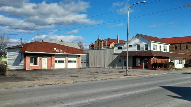
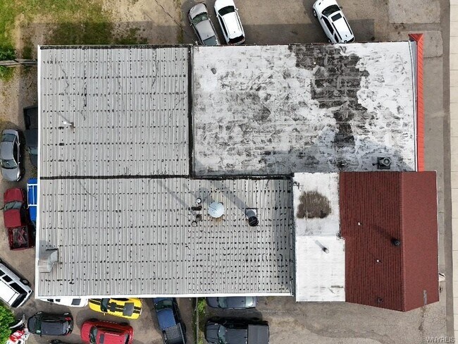
Property Record
426 Abbott Rd, Buffalo, NY 14220


This Property Is For Sale
NEARBY LISTINGS FOR SALE OR LEASE
Property Detail
426 Abbott Rd
Buffalo-Cheektowaga-Niagara Falls, NY
Buffalo Creek Reservation
140200-133-320-0004-003-100
WEST COR TAMARACK
Vehiclerentalsvehiclesales
Erie
X
New York
36029C0327J
3.100
2025
0.34 AC
2024
Greater Buffalo
000900
Buffalo/Niagara Falls
7,703 SF
DEMOGRAPHICS near 426 Abbott Rd
1 Mile
3 Mile
5 Mile
2024 Total Population
23,578
89,517
226,693
2029 Population
22,615
87,355
222,775
Pop Growth 2024-2029
(4.08%)
(2.42%)
(1.73%)
Average Age
39
40
40
2024 Total Households
10,129
39,200
100,300
HH Growth 2024-2029
(4.22%)
(2.46%)
(1.64%)
Median Household Inc
$55,690
$49,226
$47,405
Avg Household Size
2.20
2.20
2.20
2024 Avg HH Vehicles
1.00
1.00
1.00
Median Home Value
$144,071
$130,748
$146,801
Median Year Built
1946
1948
1950
Nearby Places
Map Layers
Map Styles
 Street
 Aerial
- Restaurants
- Banks
- Shops
- Fitness
- Groceries
PUBLIC TRANSPORTATION
COMMUTER RAIL
DRIVE
WALK
Distance
9 min
4.4 mi
DRIVE
WALK
Distance
17 min
8.7 mi
AIRPORT
Buffalo Niagara International
DRIVE
WALK
Distance
Buffalo Niagara International
22 min
11.8 mi
Niagara Falls International
DRIVE
WALK
Distance
Niagara Falls International
37 min
24.3 mi
Nearby Properties
Address
Land Use
TOTAL SIZE
Lot Size
Zoning
Address
Land Use
TOTAL SIZE
Lot Size
Zoning
1,053,391 SF
88.26 AC
D-IL
Address
Land Use
TOTAL SIZE
Lot Size
Zoning
425,796 SF
7.10 AC
D-M
Address
Land Use
TOTAL SIZE
Lot Size
Zoning
611,620 SF
2.20 AC
N-1S
Address
Land Use
TOTAL SIZE
Lot Size
Zoning
320,576 SF
1.90 AC
N-1S
Address
Land Use
TOTAL SIZE
Lot Size
Zoning
Address
Land Use
TOTAL SIZE
Lot Size
Zoning
1,322,238 SF
5.81 AC
N-1S
Address
Land Use
TOTAL SIZE
Lot Size
Zoning
615,144 SF
110.90 AC
N-1S
Address
Land Use
TOTAL SIZE
Lot Size
Zoning
362,095 SF
25.40 AC
D-IL
Address
Land Use
TOTAL SIZE
Lot Size
Zoning
972 SF
194.01 AC
D-OG
Address
Land Use
TOTAL SIZE
Lot Size
Zoning
5,340 SF
233.33 AC
D-ON
Address
Land Use
TOTAL SIZE
Lot Size
Zoning
80,440 SF
1.54 AC
N-1C
Address
Land Use
TOTAL SIZE
Lot Size
Zoning
702.40 AC
IND
Address
Land Use
TOTAL SIZE
Lot Size
Zoning
48.14 AC
OP
Address
Land Use
TOTAL SIZE
Lot Size
Zoning
104,881 SF
24.43 AC
12
Address
Land Use
TOTAL SIZE
Lot Size
Zoning
6,514 SF
68.20 AC
D-OG
Address
Land Use
TOTAL SIZE
Lot Size
Zoning
2,600 SF
14.80 AC
D-IL
Address
Land Use
TOTAL SIZE
Lot Size
Zoning
151,200 SF
8.36 AC
BETH
Address
Land Use
TOTAL SIZE
Lot Size
Zoning
151,200 SF
8.29 AC
IND
Address
Land Use
TOTAL SIZE
Lot Size
Zoning
43,942 SF
14.34 AC
CBD
Address
Land Use
TOTAL SIZE
Lot Size
Zoning
55.62 AC
SPLIT ZONE
Address
Land Use
TOTAL SIZE
Lot Size
Zoning
Address
Land Use
TOTAL SIZE
Lot Size
Zoning
232,570 SF
10.44 AC
D-IL
Address
Land Use
TOTAL SIZE
Lot Size
Zoning
205,680 SF
37.40 AC
11
Address
Land Use
TOTAL SIZE
Lot Size
Zoning
120,440 SF
2.24 AC
N-2E
Address
Land Use
TOTAL SIZE
Lot Size
Zoning
314,904 SF
30.05 AC
D-IL
Address
Land Use
TOTAL SIZE
Lot Size
Zoning
15.78 AC
IND
Address
Land Use
TOTAL SIZE
Lot Size
Zoning
174,812 SF
52.04 AC
05C
Address
Land Use
TOTAL SIZE
Lot Size
Zoning
7.50 AC
Address
Land Use
TOTAL SIZE
Lot Size
Zoning
107,760 SF
4.14 AC
D-E
Address
Land Use
TOTAL SIZE
Lot Size
Zoning
0.07 AC
The World's #1 Commercial Real Estate Marketplace
Connect with us
© 2026 CoStar Group
The information above has been obtained from sources believed reliable. While we do not doubt its accuracy we have not verified it and make no guarantee, warranty or representation about it. It is your responsibility to independently confirm its accuracy and completeness. Any projections, opinions, assumptions, or estimates used are for example only and do not represent the current or future performance of the property. The value of this transaction to you depends on tax and other factors which should be evaluated by your tax, financial, and legal advisors. You and your advisors should conduct a careful, independent investigation of the property to determine to your satisfaction the suitability of the property for your needs.