Property Record
416 Maple St, Litchfield, CT 06759
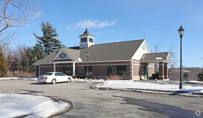

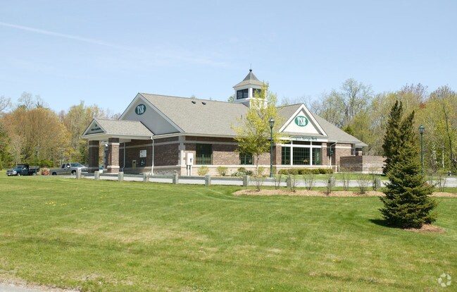
Property Detail
416 Maple St
TORR-000136-000005-000030
Litchfield
Financialbuilding
Connecticut
LB
30
2025
4.65 AC
2025
Torrington
310100
Hartford
3,334 SF
Torrington, CT
NEARBY LISTINGS FOR SALE OR LEASE
DEMOGRAPHICS near 416 Maple St
1 mile
3 mile
5 mile
2024 Total Population
4,736
30,705
43,320
2029 Population
4,732
30,712
43,492
Pop Growth 2024-2029
(0.08%)
+ 0.02%
+ 0.40%
Average Age
46
43
44
2024 Total Households
2,073
13,482
18,542
HH Growth 2024-2029
(0.10%)
+ 0.07%
+ 0.42%
Median Household Inc
$76,609
$68,593
$76,583
Avg Household Size
2.20
2.20
2.20
2024 Avg HH Vehicles
2.00
2.00
2.00
Median Home Value
$231,802
$211,811
$239,053
Median Year Built
1972
1958
1962
Nearby Places
Map Layers
Map Styles
 Street
 Aerial
Transit
 Traffic
 Biking
Places
Listings with unknown addresses are not visible on the map
- Restaurants
- Banks
- Shops
- Fitness
- Groceries
Nearby Properties
Address
Land Use
TOTAL SIZE
Lot Size
Zoning
Address
Land Use
TOTAL SIZE
Lot Size
Zoning
104.86 AC
RR
Address
Land Use
TOTAL SIZE
Lot Size
Zoning
117.77 AC
RR
Address
Land Use
TOTAL SIZE
Lot Size
Zoning
28.27 AC
RR
Address
Land Use
TOTAL SIZE
Lot Size
Zoning
160 AC
RR
Address
Land Use
TOTAL SIZE
Lot Size
Zoning
33 AC
RR
Address
Land Use
TOTAL SIZE
Lot Size
Zoning
36,531 SF
3.35 AC
HR20
Address
Land Use
TOTAL SIZE
Lot Size
Zoning
30.60 AC
HR30
Address
Land Use
TOTAL SIZE
Lot Size
Zoning
74,534 SF
6.01 AC
C202
Address
Land Use
TOTAL SIZE
Lot Size
Zoning
10.92 AC
C202
Address
Land Use
TOTAL SIZE
Lot Size
Zoning
39,585 SF
6.32 AC
GR
Address
Land Use
TOTAL SIZE
Lot Size
Zoning
8.03 AC
C202
Address
Land Use
TOTAL SIZE
Lot Size
Zoning
38,604 SF
8.95 AC
BORO 8
Address
Land Use
TOTAL SIZE
Lot Size
Zoning
469.36 AC
RR
Address
Land Use
TOTAL SIZE
Lot Size
Zoning
2.83 AC
HR30
Address
Land Use
TOTAL SIZE
Lot Size
Zoning
34,687 SF
3.51 AC
C202
Address
Land Use
TOTAL SIZE
Lot Size
Zoning
26,531 SF
10.56 AC
BORO 8
Address
Land Use
TOTAL SIZE
Lot Size
Zoning
35.70 AC
RR
Address
Land Use
TOTAL SIZE
Lot Size
Zoning
31,917 SF
10.50 AC
C202
Address
Land Use
TOTAL SIZE
Lot Size
Zoning
36,668 SF
2.58 AC
HR20
Address
Land Use
TOTAL SIZE
Lot Size
Zoning
15,876 SF
2.69 AC
BORO 8
Address
Land Use
TOTAL SIZE
Lot Size
Zoning
8.54 AC
RR
Address
Land Use
TOTAL SIZE
Lot Size
Zoning
6 AC
BORO 4
Address
Land Use
TOTAL SIZE
Lot Size
Zoning
6.50 AC
HR30
Address
Land Use
TOTAL SIZE
Lot Size
Zoning
68.60 AC
RR
Address
Land Use
TOTAL SIZE
Lot Size
Zoning
9.97 AC
RR
Address
Land Use
TOTAL SIZE
Lot Size
Zoning
9.36 AC
RR
Address
Land Use
TOTAL SIZE
Lot Size
Zoning
16,542 SF
0.58 AC
HTC
Address
Land Use
TOTAL SIZE
Lot Size
Zoning
3.93 AC
HR30
Address
Land Use
TOTAL SIZE
Lot Size
Zoning
12,678 SF
0.86 AC
C202
Address
Land Use
TOTAL SIZE
Lot Size
Zoning
6.55 AC
HR30
The World's #1 Commercial Real Estate Marketplace
Connect with us
© 2026 CoStar Group
The information above has been obtained from sources believed reliable. While we do not doubt its accuracy we have not verified it and make no guarantee, warranty or representation about it. It is your responsibility to independently confirm its accuracy and completeness. Any projections, opinions, assumptions, or estimates used are for example only and do not represent the current or future performance of the property. The value of this transaction to you depends on tax and other factors which should be evaluated by your tax, financial, and legal advisors. You and your advisors should conduct a careful, independent investigation of the property to determine to your satisfaction the suitability of the property for your needs.