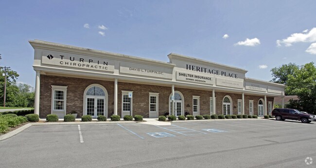
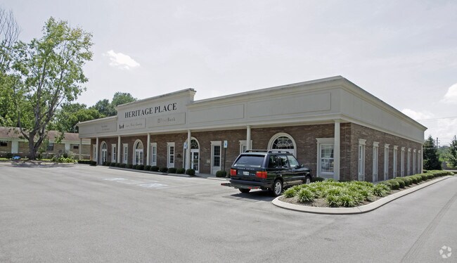
Property Record
4160 Ocoee St N, Cleveland, TN 37312
NEARBY LISTINGS FOR SALE OR LEASE
Property Detail
4160 Ocoee St N
Cleveland, TN
Cherokee Gardens
042G-C-001.00
CHEROKEE GARDENS PB: 0003 PG: 0036 HERITAGE PLACE CONDOMINIUMS; COMMON AREA 164.3 X 350 172.11 X 378.43
Utilities
Bradley
X
Tennessee
47011C0128E
3
0
1.40 AC
2025
Tennessee East Area
010201
Other Market Areas
14,520 SF
DEMOGRAPHICS near 4160 Ocoee St N
1 Mile
3 Mile
5 Mile
2024 Total Population
4,645
43,919
72,792
2029 Population
4,900
46,341
76,793
Pop Growth 2024-2029
+ 5.49%
+ 5.51%
+ 5.50%
Average Age
42
39
40
2024 Total Households
1,914
17,241
28,348
HH Growth 2024-2029
+ 5.69%
+ 5.74%
+ 5.68%
Median Household Inc
$57,485
$54,547
$54,848
Avg Household Size
2.40
2.40
2.50
2024 Avg HH Vehicles
2.00
2.00
2.00
Median Home Value
$218,445
$228,224
$223,865
Median Year Built
1983
1985
1984
Nearby Places
Map Layers
Map Styles
 Street
 Aerial
- Restaurants
- Banks
- Shops
- Fitness
- Groceries
PUBLIC TRANSPORTATION
AIRPORT
Lovell Field
DRIVE
WALK
Distance
Lovell Field
39 min
27.4 mi
Freight Ports
Georgia Ports - Savannah
DRIVE
WALK
Distance
Georgia Ports - Savannah
425 min
370.0 mi
SALE & LEASE HISTORY
LISTING DATE
SALE/LEASE

Aug 05, 2017
For Sale
Aug 03, 2017
For Lease
Nearby Properties
Address
Land Use
TOTAL SIZE
Lot Size
Zoning
Address
Land Use
TOTAL SIZE
Lot Size
Zoning
400,000 SF
123.44 AC
IH
Address
Land Use
TOTAL SIZE
Lot Size
Zoning
267,460 SF
8.30 AC
IL
Address
Land Use
TOTAL SIZE
Lot Size
Zoning
118,230 SF
37 AC
FAR
Address
Land Use
TOTAL SIZE
Lot Size
Zoning
88,644 SF
46.37 AC
R1
Address
Land Use
TOTAL SIZE
Lot Size
Zoning
68,425 SF
20 AC
MU
Address
Land Use
TOTAL SIZE
Lot Size
Zoning
93,264 SF
10.20 AC
CH
Address
Land Use
TOTAL SIZE
Lot Size
Zoning
68,785 SF
8.70 AC
R1
Address
Land Use
TOTAL SIZE
Lot Size
Zoning
356,920 SF
26.42 AC
IL
Address
Land Use
TOTAL SIZE
Lot Size
Zoning
620,857 SF
34.28 AC
IH
Address
Land Use
TOTAL SIZE
Lot Size
Zoning
213,240 SF
19.10 AC
R3
Address
Land Use
TOTAL SIZE
Lot Size
Zoning
74,392 SF
15.69 AC
MU
Address
Land Use
TOTAL SIZE
Lot Size
Zoning
203,778 SF
13.46 AC
R3
Address
Land Use
TOTAL SIZE
Lot Size
Zoning
170,518 SF
4.96 AC
CH
Address
Land Use
TOTAL SIZE
Lot Size
Zoning
416,503 SF
61.92 AC
CH
Address
Land Use
TOTAL SIZE
Lot Size
Zoning
50,400 SF
1.04 AC
CBD
Address
Land Use
TOTAL SIZE
Lot Size
Zoning
153,044 SF
16.85 AC
PUD
Address
Land Use
TOTAL SIZE
Lot Size
Zoning
782,652 SF
43.40 AC
C-1
Address
Land Use
TOTAL SIZE
Lot Size
Zoning
74,229 SF
1 AC
R1
Address
Land Use
TOTAL SIZE
Lot Size
Zoning
132,758 SF
12.30 AC
PUD
Address
Land Use
TOTAL SIZE
Lot Size
Zoning
421,180 SF
27.10 AC
IL
Address
Land Use
TOTAL SIZE
Lot Size
Zoning
141,489 SF
10.40 AC
R3
Address
Land Use
TOTAL SIZE
Lot Size
Zoning
36.78 AC
PI
Address
Land Use
TOTAL SIZE
Lot Size
Zoning
96,527 SF
5.15 AC
CH
Address
Land Use
TOTAL SIZE
Lot Size
Zoning
423,535 SF
56.59 AC
IH
Address
Land Use
TOTAL SIZE
Lot Size
Zoning
66,331 SF
10.87 AC
IL
Address
Land Use
TOTAL SIZE
Lot Size
Zoning
56,725 SF
13.10 AC
R1
Address
Land Use
TOTAL SIZE
Lot Size
Zoning
44.30 AC
IH
Address
Land Use
TOTAL SIZE
Lot Size
Zoning
203,751 SF
18.81 AC
CH
Address
Land Use
TOTAL SIZE
Lot Size
Zoning
30,526 SF
0.92 AC
CBD
Address
Land Use
TOTAL SIZE
Lot Size
Zoning
122,596 SF
5.98 AC
PUD
The World's #1 Commercial Real Estate Marketplace
Connect with us
© 2025 CoStar Group
The information above has been obtained from sources believed reliable. While we do not doubt its accuracy we have not verified it and make no guarantee, warranty or representation about it. It is your responsibility to independently confirm its accuracy and completeness. Any projections, opinions, assumptions, or estimates used are for example only and do not represent the current or future performance of the property. The value of this transaction to you depends on tax and other factors which should be evaluated by your tax, financial, and legal advisors. You and your advisors should conduct a careful, independent investigation of the property to determine to your satisfaction the suitability of the property for your needs.