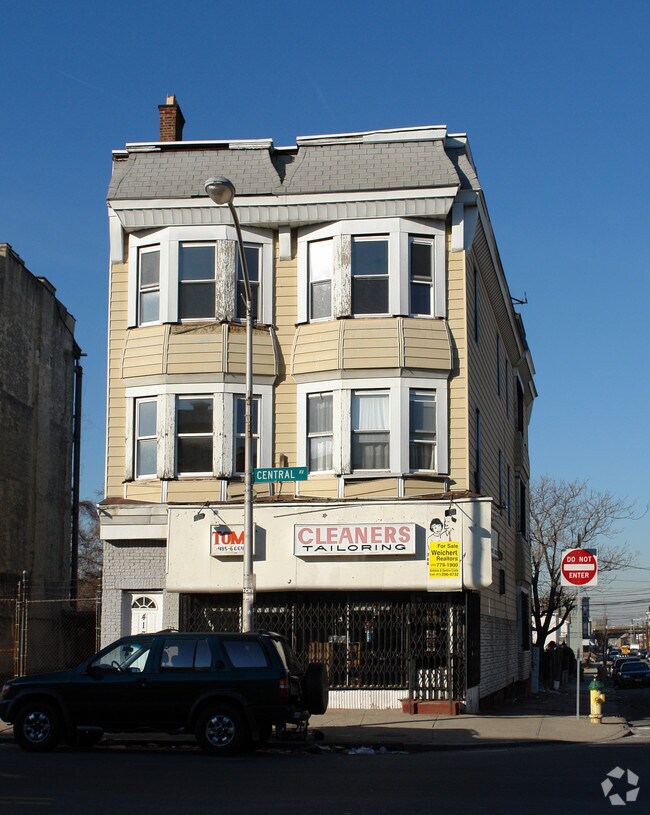
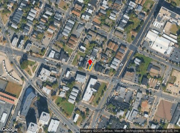
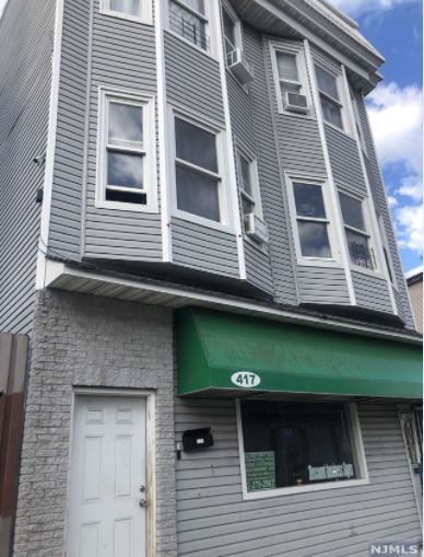
Property Record
417 Central Ave, Newark, NJ 07107
NEARBY LISTINGS FOR SALE OR LEASE
Property Detail
417 Central Ave
Newark, NJ
25X75.11
14-01847-0000-00012
Essex
Commercialnec
New Jersey
X
12
34013C0152F
0.04 AC
2023
Fairmount
2025
Northern New Jersey
001500
DEMOGRAPHICS near 417 Central Ave
1 Mile
3 Mile
5 Mile
2024 Total Population
55,554
459,057
755,382
2029 Population
53,968
444,582
733,501
Pop Growth 2024-2029
(2.85%)
(3.15%)
(2.90%)
Average Age
34
37
38
2024 Total Households
18,962
169,557
277,425
HH Growth 2024-2029
(2.69%)
(3.18%)
(2.98%)
Median Household Inc
$38,920
$48,148
$59,199
Avg Household Size
2.60
2.60
2.60
2024 Avg HH Vehicles
1.00
1.00
1.00
Median Home Value
$267,017
$299,232
$366,813
Median Year Built
1970
1963
1957
Nearby Places
Map Layers
Map Styles
 Street
 Aerial
- Restaurants
- Banks
- Shops
- Fitness
- Groceries
PUBLIC TRANSPORTATION
TRANSIT/SUBWAY
Norfolk Street (Grove Street - Newark Penn Station - Newark Light Rail (Newark Light Rail))
DRIVE
WALK
Distance
Norfolk Street (Grove Street - Newark Penn Station - Newark Light Rail (Newark Light Rail))
1 min
8 min
0.4 mi
Orange Street (Grove Street - Newark Penn Station - Newark Light Rail (Newark Light Rail))
DRIVE
WALK
Distance
Orange Street (Grove Street - Newark Penn Station - Newark Light Rail (Newark Light Rail))
2 min
9 min
0.5 mi
Warren Street (Grove Street - Newark Penn Station - Newark Light Rail (Newark Light Rail))
DRIVE
WALK
Distance
Warren Street (Grove Street - Newark Penn Station - Newark Light Rail (Newark Light Rail))
1 min
13 min
0.7 mi
Park Avenue (Grove Street - Newark Penn Station - Newark Light Rail (Newark Light Rail))
DRIVE
WALK
Distance
Park Avenue (Grove Street - Newark Penn Station - Newark Light Rail (Newark Light Rail))
2 min
18 min
0.9 mi
COMMUTER RAIL
Newark Broad Street (Montclair-Boonton Line - NJ Transit Commuter Rail (NJ Transit), Morris & Essex Gladstone Branch - NJ Transit Commuter Rail (NJ Transit), Morris & Essex Morristown Line - NJ Transit Commuter Rail (NJ Transit))
DRIVE
WALK
Distance
Newark Broad Street (Montclair-Boonton Line - NJ Transit Commuter Rail (NJ Transit), Morris & Essex Gladstone Branch - NJ Transit Commuter Rail (NJ Transit), Morris & Essex Morristown Line - NJ Transit Commuter Rail (NJ Transit))
3 min
1.2 mi
East Orange (Morris & Essex Gladstone Branch - NJ Transit Commuter Rail (NJ Transit), Morris & Essex Morristown Line - NJ Transit Commuter Rail (NJ Transit))
DRIVE
WALK
Distance
East Orange (Morris & Essex Gladstone Branch - NJ Transit Commuter Rail (NJ Transit), Morris & Essex Morristown Line - NJ Transit Commuter Rail (NJ Transit))
4 min
1.8 mi
AIRPORT
Newark Liberty International
DRIVE
WALK
Distance
Newark Liberty International
11 min
6.5 mi
LaGuardia
DRIVE
WALK
Distance
LaGuardia
42 min
27.6 mi
John F Kennedy International
DRIVE
WALK
Distance
John F Kennedy International
51 min
30.5 mi
Freight Ports
Maher Terminal
DRIVE
WALK
Distance
Maher Terminal
16 min
7.0 mi
SALE & LEASE HISTORY
LISTING DATE
SALE/LEASE

May 14, 2021
For Sale
Nearby Properties
Address
Land Use
TOTAL SIZE
Lot Size
Zoning
Address
Land Use
TOTAL SIZE
Lot Size
Zoning
0.57 AC
Address
Land Use
TOTAL SIZE
Lot Size
Zoning
57.23 AC
U
Address
Land Use
TOTAL SIZE
Lot Size
Zoning
0.45 AC
Address
Land Use
TOTAL SIZE
Lot Size
Zoning
926,120 SF
11.46 AC
Address
Land Use
TOTAL SIZE
Lot Size
Zoning
0.61 AC
Address
Land Use
TOTAL SIZE
Lot Size
Zoning
31.86 AC
Address
Land Use
TOTAL SIZE
Lot Size
Zoning
Address
Land Use
TOTAL SIZE
Lot Size
Zoning
877 SF
7.25 AC
Address
Land Use
TOTAL SIZE
Lot Size
Zoning
1,136 SF
6.51 AC
Address
Land Use
TOTAL SIZE
Lot Size
Zoning
683 SF
9.59 AC
Address
Land Use
TOTAL SIZE
Lot Size
Zoning
2.01 AC
Address
Land Use
TOTAL SIZE
Lot Size
Zoning
3.42 AC
Address
Land Use
TOTAL SIZE
Lot Size
Zoning
320 SF
1.25 AC
Address
Land Use
TOTAL SIZE
Lot Size
Zoning
9.77 AC
Address
Land Use
TOTAL SIZE
Lot Size
Zoning
877 SF
0.91 AC
Address
Land Use
TOTAL SIZE
Lot Size
Zoning
1.64 AC
Address
Land Use
TOTAL SIZE
Lot Size
Zoning
Address
Land Use
TOTAL SIZE
Lot Size
Zoning
1.63 AC
Address
Land Use
TOTAL SIZE
Lot Size
Zoning
17.97 AC
Address
Land Use
TOTAL SIZE
Lot Size
Zoning
Address
Land Use
TOTAL SIZE
Lot Size
Zoning
2.79 AC
Address
Land Use
TOTAL SIZE
Lot Size
Zoning
4.82 AC
Address
Land Use
TOTAL SIZE
Lot Size
Zoning
0.13 AC
Address
Land Use
TOTAL SIZE
Lot Size
Zoning
1,264 SF
3.20 AC
Address
Land Use
TOTAL SIZE
Lot Size
Zoning
Address
Land Use
TOTAL SIZE
Lot Size
Zoning
0.06 AC
Address
Land Use
TOTAL SIZE
Lot Size
Zoning
0.09 AC
Address
Land Use
TOTAL SIZE
Lot Size
Zoning
877 SF
1.95 AC
Address
Land Use
TOTAL SIZE
Lot Size
Zoning
877 SF
1.35 AC
Address
Land Use
TOTAL SIZE
Lot Size
Zoning
16,084 SF
7.23 AC
The World's #1 Commercial Real Estate Marketplace
Connect with us
© 2026 CoStar Group
The information above has been obtained from sources believed reliable. While we do not doubt its accuracy we have not verified it and make no guarantee, warranty or representation about it. It is your responsibility to independently confirm its accuracy and completeness. Any projections, opinions, assumptions, or estimates used are for example only and do not represent the current or future performance of the property. The value of this transaction to you depends on tax and other factors which should be evaluated by your tax, financial, and legal advisors. You and your advisors should conduct a careful, independent investigation of the property to determine to your satisfaction the suitability of the property for your needs.