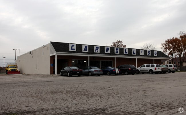
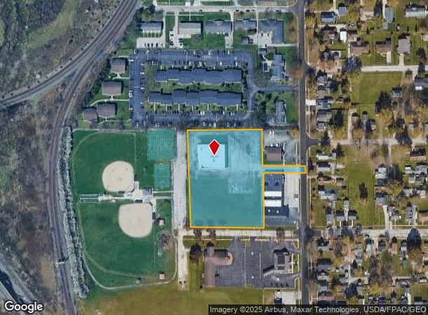
Property Record
417 N Main St, Jerry City, OH 43437
NEARBY LISTINGS FOR SALE OR LEASE
Property Detail
417 N Main St
H31-712-050401025000
W360 E530 N407 S1574.95 SE LESS W45.02
Commercialnec
Wood
X
Ohio
39173C0053D
2.89 AC
2023
Perrysburg/Northwood
2024
Toledo
022500
Toledo, OH
11,316 SF
DEMOGRAPHICS near 417 N Main St
1 Mile
3 Mile
5 Mile
2024 Total Population
3,314
24,049
84,556
2029 Population
3,375
24,146
84,924
Pop Growth 2024-2029
+ 1.84%
+ 0.40%
+ 0.44%
Average Age
47
40
39
2024 Total Households
1,680
10,363
35,263
HH Growth 2024-2029
+ 1.96%
+ 0.40%
+ 0.36%
Median Household Inc
$42,980
$53,635
$47,071
Avg Household Size
2.00
2.20
2.30
2024 Avg HH Vehicles
2.00
2.00
2.00
Median Home Value
$120,505
$135,899
$126,909
Median Year Built
1971
1970
1960
Nearby Places
Map Layers
Map Styles
 Street
 Aerial
- Restaurants
- Banks
- Shops
- Fitness
- Groceries
PUBLIC TRANSPORTATION
COMMUTER RAIL
Toledo (Capitol Limited - Amtrak, Lake Shore Limited - Amtrak)
DRIVE
WALK
Distance
Toledo (Capitol Limited - Amtrak, Lake Shore Limited - Amtrak)
14 min
6.1 mi
AIRPORT
Eugene F Kranz Toledo Express
DRIVE
WALK
Distance
Eugene F Kranz Toledo Express
41 min
21.6 mi
Freight Ports
Port of Toledo
DRIVE
WALK
Distance
Port of Toledo
20 min
9.2 mi
SALE & LEASE HISTORY
LISTING DATE
SALE/LEASE

Sep 24, 2016
For Sale
Mar 23, 2017
For Sale
Nearby Properties
Address
Land Use
TOTAL SIZE
Lot Size
Zoning
Address
Land Use
TOTAL SIZE
Lot Size
Zoning
1,136,896 SF
73.62 AC
Address
Land Use
TOTAL SIZE
Lot Size
Zoning
1,124,336 SF
79.67 AC
Address
Land Use
TOTAL SIZE
Lot Size
Zoning
504,154 SF
111.51 AC
Address
Land Use
TOTAL SIZE
Lot Size
Zoning
313,004 SF
44.54 AC
40-C2
Address
Land Use
TOTAL SIZE
Lot Size
Zoning
496,062 SF
50.37 AC
Address
Land Use
TOTAL SIZE
Lot Size
Zoning
226,469 SF
17.38 AC
Address
Land Use
TOTAL SIZE
Lot Size
Zoning
219,265 SF
32.11 AC
Address
Land Use
TOTAL SIZE
Lot Size
Zoning
176,125 SF
21.61 AC
Address
Land Use
TOTAL SIZE
Lot Size
Zoning
136,090 SF
4 AC
Address
Land Use
TOTAL SIZE
Lot Size
Zoning
127,658 SF
9.01 AC
40-C4
Address
Land Use
TOTAL SIZE
Lot Size
Zoning
486,615 SF
45.39 AC
Address
Land Use
TOTAL SIZE
Lot Size
Zoning
170,760 SF
51.98 AC
Address
Land Use
TOTAL SIZE
Lot Size
Zoning
225,918 SF
17.15 AC
Address
Land Use
TOTAL SIZE
Lot Size
Zoning
349,799 SF
51.86 AC
Address
Land Use
TOTAL SIZE
Lot Size
Zoning
102,535 SF
20 AC
40-R2
Address
Land Use
TOTAL SIZE
Lot Size
Zoning
228,251 SF
43.08 AC
10-RD6
Address
Land Use
TOTAL SIZE
Lot Size
Zoning
100,531 SF
3.07 AC
Address
Land Use
TOTAL SIZE
Lot Size
Zoning
152,163 SF
2.49 AC
Address
Land Use
TOTAL SIZE
Lot Size
Zoning
34 AC
40-C5
Address
Land Use
TOTAL SIZE
Lot Size
Zoning
230,074 SF
142.89 AC
40-M2
Address
Land Use
TOTAL SIZE
Lot Size
Zoning
181,347 SF
14.12 AC
40-R4
Address
Land Use
TOTAL SIZE
Lot Size
Zoning
351,114 SF
26.32 AC
10-MX
Address
Land Use
TOTAL SIZE
Lot Size
Zoning
65,683 SF
5.02 AC
10-MX
Address
Land Use
TOTAL SIZE
Lot Size
Zoning
128,000 SF
9.37 AC
Address
Land Use
TOTAL SIZE
Lot Size
Zoning
123,975 SF
6.03 AC
Address
Land Use
TOTAL SIZE
Lot Size
Zoning
115,239 SF
12.89 AC
Address
Land Use
TOTAL SIZE
Lot Size
Zoning
159,802 SF
2.15 AC
Address
Land Use
TOTAL SIZE
Lot Size
Zoning
132,284 SF
22.10 AC
Address
Land Use
TOTAL SIZE
Lot Size
Zoning
331,416 SF
30.56 AC
Address
Land Use
TOTAL SIZE
Lot Size
Zoning
199,768 SF
16.15 AC
40-C2
The World's #1 Commercial Real Estate Marketplace
Connect with us
© 2025 CoStar Group
The information above has been obtained from sources believed reliable. While we do not doubt its accuracy we have not verified it and make no guarantee, warranty or representation about it. It is your responsibility to independently confirm its accuracy and completeness. Any projections, opinions, assumptions, or estimates used are for example only and do not represent the current or future performance of the property. The value of this transaction to you depends on tax and other factors which should be evaluated by your tax, financial, and legal advisors. You and your advisors should conduct a careful, independent investigation of the property to determine to your satisfaction the suitability of the property for your needs.