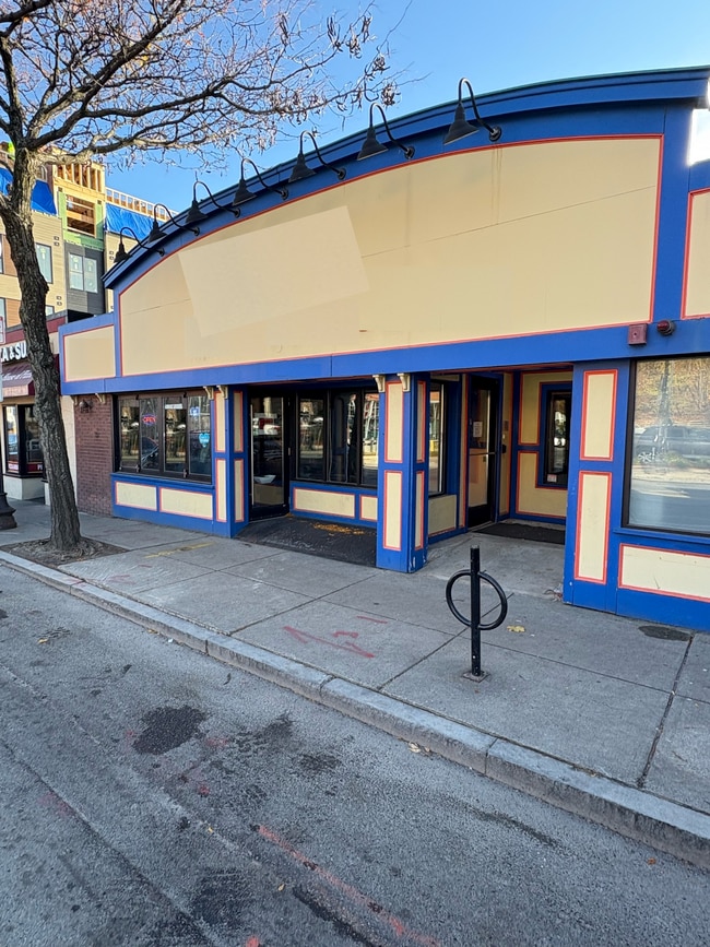
Property Record
4170 Washington St, Roslindale, MA 02131


Current Lease Availabilities
NEARBY LISTINGS FOR SALE OR LEASE
Property Detail
4170 Washington St
ROSL-000000-000019-003123-000010
Plan 3233-K
Restaurantbuilding
Suffolk
X
Massachusetts
25021C0042E
0.11 AC
2025
South Suffolk County
2025
Boston
110401
Boston-Cambridge-Newton, MA-NH
4,032 SF
DEMOGRAPHICS near 4170 Washington St
1 Mile
3 Mile
5 Mile
2024 Total Population
29,022
228,069
644,646
2029 Population
27,251
216,353
619,005
Pop Growth 2024-2029
(6.10%)
(5.14%)
(3.98%)
Average Age
42
40
38
2024 Total Households
11,316
86,244
251,841
HH Growth 2024-2029
(6.80%)
(5.74%)
(4.39%)
Median Household Inc
$96,865
$85,099
$84,253
Avg Household Size
2.40
2.50
2.30
2024 Avg HH Vehicles
1.00
1.00
1.00
Median Home Value
$648,180
$667,486
$759,956
Median Year Built
1947
1949
1949
Nearby Places
Map Layers
Map Styles
 Street
 Aerial
- Restaurants
- Banks
- Shops
- Fitness
- Groceries
PUBLIC TRANSPORTATION
TRANSIT/SUBWAY
Roslindale Village (Needham Line - Massachusetts Bay Transportation Authority Commuter Rail (Purple Line))
DRIVE
WALK
Distance
Roslindale Village (Needham Line - Massachusetts Bay Transportation Authority Commuter Rail (Purple Line))
2 min
5 min
0.3 mi
COMMUTER RAIL
Roslindale Village (Needham Line - Massachusetts Bay Transportation Authority Commuter Rail (Purple Line))
DRIVE
WALK
Distance
Roslindale Village (Needham Line - Massachusetts Bay Transportation Authority Commuter Rail (Purple Line))
2 min
5 min
0.3 mi
Forest Hills (Needham Line - Massachusetts Bay Transportation Authority Commuter Rail (Purple Line))
DRIVE
WALK
Distance
Forest Hills (Needham Line - Massachusetts Bay Transportation Authority Commuter Rail (Purple Line))
3 min
1.1 mi
AIRPORT
General Edward Lawrence Logan International
DRIVE
WALK
Distance
General Edward Lawrence Logan International
25 min
9.4 mi
Freight Ports
Port of Boston
DRIVE
WALK
Distance
Port of Boston
18 min
7.8 mi
Nearby Properties
Address
Land Use
TOTAL SIZE
Lot Size
Zoning
Address
Land Use
TOTAL SIZE
Lot Size
Zoning
262,120 SF
0.62 AC
C
Address
Land Use
TOTAL SIZE
Lot Size
Zoning
146,751 SF
3.39 AC
E
Address
Land Use
TOTAL SIZE
Lot Size
Zoning
317,049 SF
11.22 AC
M05
Address
Land Use
TOTAL SIZE
Lot Size
Zoning
428,271 SF
9.65 AC
E
Address
Land Use
TOTAL SIZE
Lot Size
Zoning
14.59 AC
S40
Address
Land Use
TOTAL SIZE
Lot Size
Zoning
203,252 SF
236.88 AC
S40
Address
Land Use
TOTAL SIZE
Lot Size
Zoning
45,000 SF
14.30 AC
E
Address
Land Use
TOTAL SIZE
Lot Size
Zoning
355,941 SF
4.60 AC
A
Address
Land Use
TOTAL SIZE
Lot Size
Zoning
163,364 SF
3.08 AC
O10
Address
Land Use
TOTAL SIZE
Lot Size
Zoning
351,680 SF
4.01 AC
RC
Address
Land Use
TOTAL SIZE
Lot Size
Zoning
25,744 SF
35.80 AC
S40
Address
Land Use
TOTAL SIZE
Lot Size
Zoning
179.13 AC
E
Address
Land Use
TOTAL SIZE
Lot Size
Zoning
5,119 SF
119.98 AC
S15
Address
Land Use
TOTAL SIZE
Lot Size
Zoning
1,940 SF
58.17 AC
E
Address
Land Use
TOTAL SIZE
Lot Size
Zoning
240.18 AC
E
Address
Land Use
TOTAL SIZE
Lot Size
Zoning
332,366 SF
4.86 AC
E
Address
Land Use
TOTAL SIZE
Lot Size
Zoning
228,215 SF
2.44 AC
RC
Address
Land Use
TOTAL SIZE
Lot Size
Zoning
18,070 SF
119.45 AC
E
Address
Land Use
TOTAL SIZE
Lot Size
Zoning
526,040 SF
27.79 AC
E
Address
Land Use
TOTAL SIZE
Lot Size
Zoning
21,830 SF
158.48 AC
E
Address
Land Use
TOTAL SIZE
Lot Size
Zoning
137,800 SF
5.67 AC
E
Address
Land Use
TOTAL SIZE
Lot Size
Zoning
2,781 SF
60.98 AC
S40
Address
Land Use
TOTAL SIZE
Lot Size
Zoning
95,597 SF
0.91 AC
L05
Address
Land Use
TOTAL SIZE
Lot Size
Zoning
53.23 AC
E
Address
Land Use
TOTAL SIZE
Lot Size
Zoning
377,249 SF
2.81 AC
RC
Address
Land Use
TOTAL SIZE
Lot Size
Zoning
173,630 SF
4.46 AC
E
Address
Land Use
TOTAL SIZE
Lot Size
Zoning
3.18 AC
M05
Address
Land Use
TOTAL SIZE
Lot Size
Zoning
24.20 AC
S25
Address
Land Use
TOTAL SIZE
Lot Size
Zoning
14.64 AC
S15
Address
Land Use
TOTAL SIZE
Lot Size
Zoning
26,569 SF
45.93 AC
RC
The World's #1 Commercial Real Estate Marketplace
Connect with us
© 2026 CoStar Group
The information above has been obtained from sources believed reliable. While we do not doubt its accuracy we have not verified it and make no guarantee, warranty or representation about it. It is your responsibility to independently confirm its accuracy and completeness. Any projections, opinions, assumptions, or estimates used are for example only and do not represent the current or future performance of the property. The value of this transaction to you depends on tax and other factors which should be evaluated by your tax, financial, and legal advisors. You and your advisors should conduct a careful, independent investigation of the property to determine to your satisfaction the suitability of the property for your needs.