Property Record
4171 33Rd St, San Diego, CA 92104
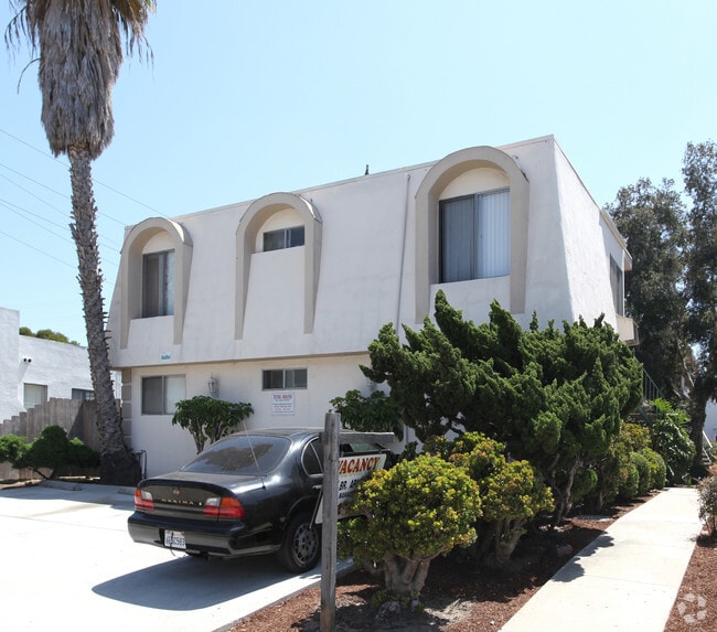
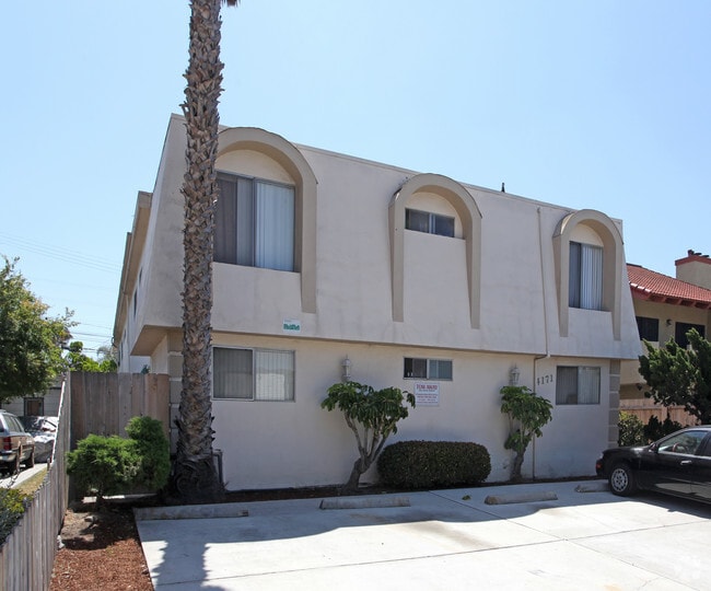

This Property Is For Sale
NEARBY LISTINGS FOR SALE OR LEASE
Property Detail
4171 33Rd St
San Diego-Carlsbad, CA
Teralta Heights
447-571-04
BLK 3 LOTS 5 & 6 TR 001237
Multifamilydwelling
San Diego
X
California
06073C1638H
5,6
2024
0.16 AC
2025
Corridor
001600
San Diego
6,011 SF
DEMOGRAPHICS near 4171 33Rd St
1 Mile
3 Mile
5 Mile
2024 Total Population
53,314
258,080
600,859
2029 Population
53,127
257,501
599,120
Pop Growth 2024-2029
(0.35%)
(0.22%)
(0.29%)
Average Age
37
38
38
2024 Total Households
25,627
114,878
236,736
HH Growth 2024-2029
(0.48%)
(0.24%)
(0.21%)
Median Household Inc
$73,816
$75,693
$74,426
Avg Household Size
2.00
2.20
2.30
2024 Avg HH Vehicles
1.00
2.00
2.00
Median Home Value
$707,777
$735,979
$720,965
Median Year Built
1971
1972
1974
Nearby Places
- Restaurants
- Banks
- Shops
- Fitness
- Groceries
PUBLIC TRANSPORTATION
COMMUTER RAIL
San Diego (Santa Fe Depot) (Coaster - San Diego North County Transit District (Coaster/Sprinter/Breeze))
DRIVE
WALK
Distance
San Diego (Santa Fe Depot) (Coaster - San Diego North County Transit District (Coaster/Sprinter/Breeze))
11 min
5.8 mi
Old Town Transit Center (Coaster - San Diego North County Transit District (Coaster/Sprinter/Breeze))
DRIVE
WALK
Distance
Old Town Transit Center (Coaster - San Diego North County Transit District (Coaster/Sprinter/Breeze))
12 min
6.3 mi
AIRPORT
San Diego International
DRIVE
WALK
Distance
San Diego International
12 min
4.9 mi
Freight Ports
Port of San Diego
DRIVE
WALK
Distance
Port of San Diego
13 min
5.7 mi
Nearby Properties
Address
Land Use
TOTAL SIZE
Lot Size
Zoning
Address
Land Use
TOTAL SIZE
Lot Size
Zoning
30,000 SF
62.51 AC
MVPD-MV-CR
Address
Land Use
TOTAL SIZE
Lot Size
Zoning
4,774 SF
74.75 AC
RM-2-5
Address
Land Use
TOTAL SIZE
Lot Size
Zoning
107.28 AC
UNZONED
Address
Land Use
TOTAL SIZE
Lot Size
Zoning
2.53 AC
EMX-1
Address
Land Use
TOTAL SIZE
Lot Size
Zoning
4.41 AC
CC-3-8
Address
Land Use
TOTAL SIZE
Lot Size
Zoning
1.51 AC
CC-3-9
Address
Land Use
TOTAL SIZE
Lot Size
Zoning
RM-4-10
Address
Land Use
TOTAL SIZE
Lot Size
Zoning
19.25 AC
CC-3-5
Address
Land Use
TOTAL SIZE
Lot Size
Zoning
15.37 AC
CC-3-8
Address
Land Use
TOTAL SIZE
Lot Size
Zoning
5.02 AC
CC-3-8
Address
Land Use
TOTAL SIZE
Lot Size
Zoning
54,240 SF
8.18 AC
MVPD-MVR-2
Address
Land Use
TOTAL SIZE
Lot Size
Zoning
2.50 AC
MVPD-MV-CO
Address
Land Use
TOTAL SIZE
Lot Size
Zoning
5.35 AC
MVPD-MV-CR
Address
Land Use
TOTAL SIZE
Lot Size
Zoning
3.97 AC
C
Address
Land Use
TOTAL SIZE
Lot Size
Zoning
7.69 AC
MVPD-MV-M/
Address
Land Use
TOTAL SIZE
Lot Size
Zoning
13.04 AC
RM-2-5
Address
Land Use
TOTAL SIZE
Lot Size
Zoning
7.19 AC
MVPD-MV-M/
Address
Land Use
TOTAL SIZE
Lot Size
Zoning
17.35 AC
C-6
Address
Land Use
TOTAL SIZE
Lot Size
Zoning
902,919 SF
45.23 AC
MVPD-MV-CR
Address
Land Use
TOTAL SIZE
Lot Size
Zoning
2.90 AC
MVPD-MV-CR
Address
Land Use
TOTAL SIZE
Lot Size
Zoning
1.99 AC
EMX-1
Address
Land Use
TOTAL SIZE
Lot Size
Zoning
1.81 AC
EMX-1
Address
Land Use
TOTAL SIZE
Lot Size
Zoning
6.68 AC
RM-3-7
Address
Land Use
TOTAL SIZE
Lot Size
Zoning
16.91 AC
EMX-1
Address
Land Use
TOTAL SIZE
Lot Size
Zoning
3.36 AC
RM-4-10
Address
Land Use
TOTAL SIZE
Lot Size
Zoning
194,809 SF
19.82 AC
MVPD-MV-M/
Address
Land Use
TOTAL SIZE
Lot Size
Zoning
19.67 AC
RM-2-5
Address
Land Use
TOTAL SIZE
Lot Size
Zoning
2.46 AC
CC-3-5
Address
Land Use
TOTAL SIZE
Lot Size
Zoning
7.10 AC
MVPD-MV-CO
Address
Land Use
TOTAL SIZE
Lot Size
Zoning
15.40 AC
MVPD-MV-M
The World's #1 Commercial Real Estate Marketplace
Connect with us
© 2025 CoStar Group
The information above has been obtained from sources believed reliable. While we do not doubt its accuracy we have not verified it and make no guarantee, warranty or representation about it. It is your responsibility to independently confirm its accuracy and completeness. Any projections, opinions, assumptions, or estimates used are for example only and do not represent the current or future performance of the property. The value of this transaction to you depends on tax and other factors which should be evaluated by your tax, financial, and legal advisors. You and your advisors should conduct a careful, independent investigation of the property to determine to your satisfaction the suitability of the property for your needs.