Property Record
4171 E Parsons Point Rd, Hernando, FL 34442
NEARBY LISTINGS FOR SALE OR LEASE
-
-
View all Hernando listings for sale on LoopNet.com
Property Detail
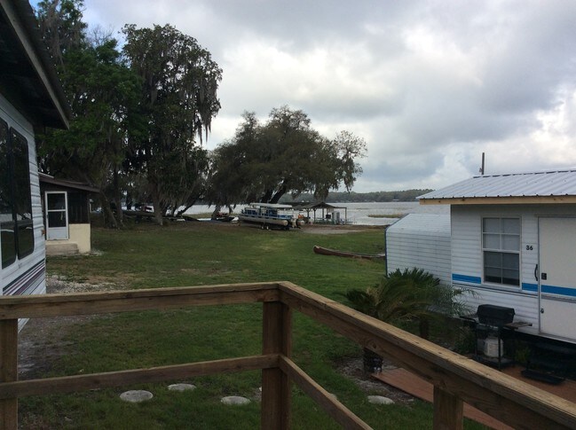
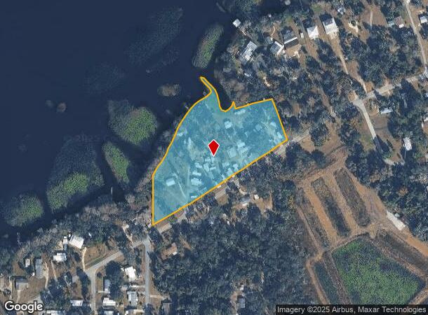
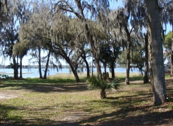
4171 E Parsons Point Rd
Homosassa Springs, FL
Parson`S Point Addition To Her
19E-18S-24-0010-00310-0090
PT OF BEACH ADJ TO & N OF LOT 25 BL K 30 FURTHER DESC IN OR BK 790 PG 776(LEASE AGREE IN O R B K 816 PG 1293(LOT17) & OR BK 816 PG 1301(LT 13) ---&--- PARSONS PT ADD TO HERNANDO S1/2 OF LOTS 9 10 11 & 12 & ALL OF LOT 13 14 15 16 17 26 27 28 29 30 31
Parkinglot
Citrus
AE
Florida
12017C0238D
25
2024
5.02 AC
2025
Florida Central North Area
450800
Other Market Areas
4,658 SF
DEMOGRAPHICS near 4171 E Parsons Point Rd
1 Mile
3 Mile
5 Mile
2024 Total Population
1,340
10,963
32,193
2029 Population
1,540
12,504
36,713
Pop Growth 2024-2029
+ 14.93%
+ 14.06%
+ 14.04%
Average Age
52
50
51
2024 Total Households
663
4,994
14,804
HH Growth 2024-2029
+ 14.63%
+ 13.90%
+ 13.87%
Median Household Inc
$41,583
$44,337
$45,448
Avg Household Size
2.00
2.10
2.10
2024 Avg HH Vehicles
2.00
2.00
2.00
Median Home Value
$161,904
$173,327
$207,017
Median Year Built
1978
1991
1989
Nearby Places
Map Layers
Map Styles
 Street
 Aerial
- Restaurants
- Banks
- Shops
- Fitness
- Groceries
SALE & LEASE HISTORY
LISTING DATE
SALE/LEASE

Dec 05, 2016
For Sale
Nearby Properties
Address
Land Use
TOTAL SIZE
Lot Size
Zoning
Address
Land Use
TOTAL SIZE
Lot Size
Zoning
84,611 SF
33.22 AC
PSI
Address
Land Use
TOTAL SIZE
Lot Size
Zoning
119,399 SF
4.77 AC
GNC
Address
Land Use
TOTAL SIZE
Lot Size
Zoning
74,320 SF
4.51 AC
GNC
Address
Land Use
TOTAL SIZE
Lot Size
Zoning
40,648 SF
4.85 AC
GNC
Address
Land Use
TOTAL SIZE
Lot Size
Zoning
18,114 SF
9.11 AC
GNC
Address
Land Use
TOTAL SIZE
Lot Size
Zoning
728 SF
14.64 AC
MHP
Address
Land Use
TOTAL SIZE
Lot Size
Zoning
24,600 SF
1.64 AC
LDR
Address
Land Use
TOTAL SIZE
Lot Size
Zoning
46,900 SF
2.04 AC
GNC
Address
Land Use
TOTAL SIZE
Lot Size
Zoning
42,640 SF
5.04 AC
GNC
Address
Land Use
TOTAL SIZE
Lot Size
Zoning
17,008 SF
5.07 AC
LDRMH
Address
Land Use
TOTAL SIZE
Lot Size
Zoning
28,222 SF
15.81 AC
LDRMH
Address
Land Use
TOTAL SIZE
Lot Size
Zoning
28,078 SF
3.48 AC
GNC
Address
Land Use
TOTAL SIZE
Lot Size
Zoning
31,200 SF
3.58 AC
GNC
Address
Land Use
TOTAL SIZE
Lot Size
Zoning
8,650 SF
3.55 AC
GNC
Address
Land Use
TOTAL SIZE
Lot Size
Zoning
28,006 SF
2.05 AC
GNC
Address
Land Use
TOTAL SIZE
Lot Size
Zoning
24.12 AC
RVP
Address
Land Use
TOTAL SIZE
Lot Size
Zoning
29,130 SF
3.27 AC
GNC
Address
Land Use
TOTAL SIZE
Lot Size
Zoning
11,384 SF
6.96 AC
GNC
Address
Land Use
TOTAL SIZE
Lot Size
Zoning
8,574 SF
1.13 AC
MDRMH
Address
Land Use
TOTAL SIZE
Lot Size
Zoning
9,230 SF
1.52 AC
PDR
Address
Land Use
TOTAL SIZE
Lot Size
Zoning
1,200 SF
43.89 AC
PSI
Address
Land Use
TOTAL SIZE
Lot Size
Zoning
10,162 SF
137.04 AC
CL
Address
Land Use
TOTAL SIZE
Lot Size
Zoning
9,780 SF
11.86 AC
CL
Address
Land Use
TOTAL SIZE
Lot Size
Zoning
17,664 SF
2.02 AC
GNC
Address
Land Use
TOTAL SIZE
Lot Size
Zoning
20,038 SF
4.78 AC
CLR
Address
Land Use
TOTAL SIZE
Lot Size
Zoning
18,666 SF
1.87 AC
GNC
Address
Land Use
TOTAL SIZE
Lot Size
Zoning
21,120 SF
1.75 AC
IND
Address
Land Use
TOTAL SIZE
Lot Size
Zoning
48,545 SF
7.22 AC
HDR
Address
Land Use
TOTAL SIZE
Lot Size
Zoning
26,964 SF
3.75 AC
PSI
The World's #1 Commercial Real Estate Marketplace
Connect with us
© 2025 CoStar Group
The information above has been obtained from sources believed reliable. While we do not doubt its accuracy we have not verified it and make no guarantee, warranty or representation about it. It is your responsibility to independently confirm its accuracy and completeness. Any projections, opinions, assumptions, or estimates used are for example only and do not represent the current or future performance of the property. The value of this transaction to you depends on tax and other factors which should be evaluated by your tax, financial, and legal advisors. You and your advisors should conduct a careful, independent investigation of the property to determine to your satisfaction the suitability of the property for your needs.