Property Record
4171 Hammock Rd, Mims, FL 32754
NEARBY LISTINGS FOR SALE OR LEASE
-
-
View all Mims listings for sale on LoopNet.com
Property Detail
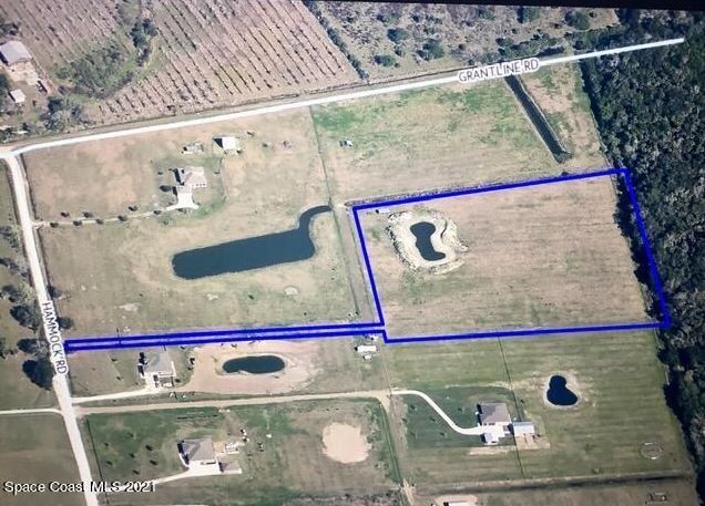
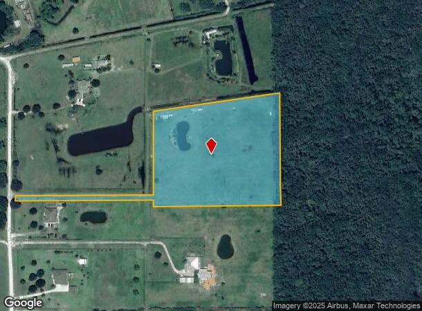
4171 Hammock Rd
20-35-32-00-00269.0-0000.00
PART OF GOVT LOT 3 AS DESC IN ORB 6506 PG 695
Pasture
Brevard
AE
Florida
12009C0105H
3
2024
7.86 AC
2025
Brevard County
060105
Orlando
4,288 SF
Palm Bay-Melbourne-Titusville, FL
DEMOGRAPHICS near 4171 Hammock Rd
1 Mile
3 Mile
5 Mile
2024 Total Population
509
6,888
16,757
2029 Population
550
7,660
18,469
Pop Growth 2024-2029
+ 8.06%
+ 11.21%
+ 10.22%
Average Age
45
46
46
2024 Total Households
196
2,908
6,990
HH Growth 2024-2029
+ 7.65%
+ 11.11%
+ 10.13%
Median Household Inc
$96,590
$57,116
$59,602
Avg Household Size
2.50
2.30
2.30
2024 Avg HH Vehicles
3.00
2.00
2.00
Median Home Value
$399,999
$253,186
$245,660
Median Year Built
1997
1985
1986
Nearby Places
Map Layers
Map Styles
 Street
 Aerial
- Restaurants
- Banks
- Shops
- Fitness
- Groceries
SALE & LEASE HISTORY
LISTING DATE
SALE/LEASE

Nov 18, 2021
For Sale
Nov 01, 2018
For Sale
Nearby Properties
Address
Land Use
TOTAL SIZE
Lot Size
Zoning
Address
Land Use
TOTAL SIZE
Lot Size
Zoning
70,928 SF
15 AC
RU-1-9
Address
Land Use
TOTAL SIZE
Lot Size
Zoning
87.58 AC
GML
Address
Land Use
TOTAL SIZE
Lot Size
Zoning
36,557 SF
5.62 AC
IN(L)
Address
Land Use
TOTAL SIZE
Lot Size
Zoning
17,042 SF
2.75 AC
BU2
Address
Land Use
TOTAL SIZE
Lot Size
Zoning
4,860 SF
10.38 AC
RVP
Address
Land Use
TOTAL SIZE
Lot Size
Zoning
4,164 SF
8.98 AC
RVP
Address
Land Use
TOTAL SIZE
Lot Size
Zoning
22,879 SF
6.48 AC
PUD
Address
Land Use
TOTAL SIZE
Lot Size
Zoning
10,291 SF
10.45 AC
BU-2
Address
Land Use
TOTAL SIZE
Lot Size
Zoning
24,656 SF
6.69 AC
BU1BU2
Address
Land Use
TOTAL SIZE
Lot Size
Zoning
9,100 SF
1.48 AC
BU-1
Address
Land Use
TOTAL SIZE
Lot Size
Zoning
22,155 SF
2.18 AC
BU2
Address
Land Use
TOTAL SIZE
Lot Size
Zoning
7,598 SF
3.02 AC
GML
Address
Land Use
TOTAL SIZE
Lot Size
Zoning
133.98 AC
PUD
Address
Land Use
TOTAL SIZE
Lot Size
Zoning
9,250 SF
28.63 AC
INL
Address
Land Use
TOTAL SIZE
Lot Size
Zoning
59.45 AC
RU-1-11
Address
Land Use
TOTAL SIZE
Lot Size
Zoning
9,600 SF
6.56 AC
BU-1
Address
Land Use
TOTAL SIZE
Lot Size
Zoning
163.33 AC
PUD
Address
Land Use
TOTAL SIZE
Lot Size
Zoning
14,282 SF
1.65 AC
BU-2
Address
Land Use
TOTAL SIZE
Lot Size
Zoning
5,311 SF
7.24 AC
AU
Address
Land Use
TOTAL SIZE
Lot Size
Zoning
19,294 SF
22.02 AC
IU-1
Address
Land Use
TOTAL SIZE
Lot Size
Zoning
8,016 SF
5 AC
AU
Address
Land Use
TOTAL SIZE
Lot Size
Zoning
4,209 SF
39.08 AC
AU
Address
Land Use
TOTAL SIZE
Lot Size
Zoning
9,500 SF
5 AC
AU
Address
Land Use
TOTAL SIZE
Lot Size
Zoning
70.31 AC
PUD
Address
Land Use
TOTAL SIZE
Lot Size
Zoning
205.20 AC
GML(H)
Address
Land Use
TOTAL SIZE
Lot Size
Zoning
9,624 SF
5.13 AC
BU1
Address
Land Use
TOTAL SIZE
Lot Size
Zoning
8,187 SF
1.82 AC
BU-2
Address
Land Use
TOTAL SIZE
Lot Size
Zoning
8,534 SF
19.47 AC
AU
Address
Land Use
TOTAL SIZE
Lot Size
Zoning
7,026 SF
2.26 AC
BU-1
Address
Land Use
TOTAL SIZE
Lot Size
Zoning
60.21 AC
PUD
The World's #1 Commercial Real Estate Marketplace
Connect with us
© 2026 CoStar Group
The information above has been obtained from sources believed reliable. While we do not doubt its accuracy we have not verified it and make no guarantee, warranty or representation about it. It is your responsibility to independently confirm its accuracy and completeness. Any projections, opinions, assumptions, or estimates used are for example only and do not represent the current or future performance of the property. The value of this transaction to you depends on tax and other factors which should be evaluated by your tax, financial, and legal advisors. You and your advisors should conduct a careful, independent investigation of the property to determine to your satisfaction the suitability of the property for your needs.