Property Record
4175 E Iliff Ave, Denver, CO 80222
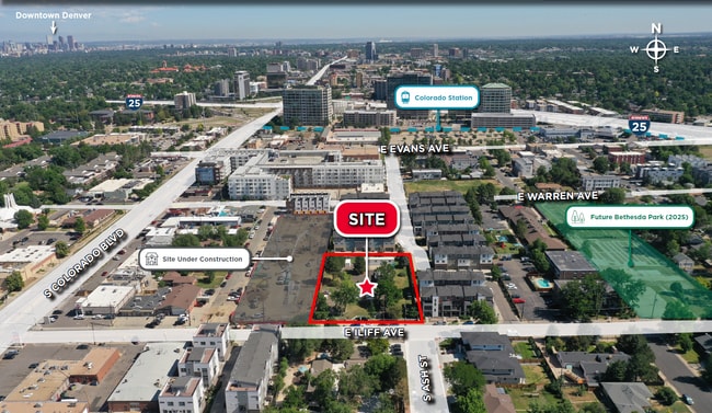

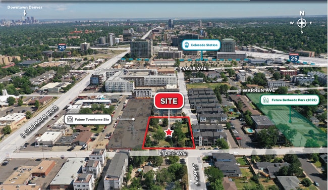
This Property Is For Sale
Property Detail
4175 E Iliff Ave
6302-14-006
L 25 TO 34 INC BLK 102 WARRENS UNIVERSITY HTS 2ND FLG & W1/2 OF VAC S ASH ST
Animalhospitalvet
Denver
S-MX-3
Colorado
B and X Area of moderate flood hazard, usually the area between the limits of the 100-year and 500-year floods.
25-34
2024
0.88 AC
2025
Colorado Blvd/I-25
005300
Denver
4,281 SF
Denver-Aurora-Centennial, CO
NEARBY LISTINGS FOR SALE OR LEASE
DEMOGRAPHICS near 4175 E Iliff Ave
1 mile
3 mile
5 mile
2025 Total Population
18,285
167,710
456,958
2030 Population
18,781
171,617
467,185
Pop Growth 2025-2030
+ 2.71%
+ 2.33%
+ 2.24%
Average Age
41
40
39
2025 Total Households
8,438
78,260
217,359
HH Growth 2025-2030
+ 2.94%
+ 2.46%
+ 2.39%
Median Household Inc
$90,154
$96,647
$90,496
Avg Household Size
2.10
2.10
2.00
2025 Avg HH Vehicles
2.00
2.00
2.00
Median Home Value
$772,912
$792,825
$720,627
Median Year Built
1965
1973
1974
Nearby Places
Map Layers
Map Styles
 Street
 Aerial
Transit
 Traffic
 Biking
Places
Listings with unknown addresses are not visible on the map
- Restaurants
- Banks
- Shops
- Fitness
- Groceries
PUBLIC TRANSPORTATION
COMMUTER RAIL
Drive
Walk
Distance
18 min
7.3 mi
Union Station: LoDo-Coors Field-16th Street Mall (C Line - Denver Regional Transportation District Light Rail (TheRide), E Line - Denver Regional Transportation District Light Rail (TheRide), W Line - Denver Regional Transportation District Light Rail (TheRide))
Drive
Walk
Distance
Union Station: LoDo-Coors Field-16th Street Mall (C Line - Denver Regional Transportation District Light Rail (TheRide), E Line - Denver Regional Transportation District Light Rail (TheRide), W Line - Denver Regional Transportation District Light Rail (TheRide))
14 min
8.4 mi
AIRPORT
Denver International
Drive
Walk
Distance
Denver International
37 min
29.4 mi
Nearby Properties
Address
Land Use
TOTAL SIZE
Lot Size
Zoning
Address
Land Use
TOTAL SIZE
Lot Size
Zoning
472,235 SF
1.98 AC
C-RX
Address
Land Use
TOTAL SIZE
Lot Size
Zoning
451,860 SF
1 AC
C-MX
Address
Land Use
TOTAL SIZE
Lot Size
Zoning
508,135 SF
6.99 AC
C-RX
Address
Land Use
TOTAL SIZE
Lot Size
Zoning
377,735 SF
1.72 AC
G-RX
Address
Land Use
TOTAL SIZE
Lot Size
Zoning
422,426 SF
1.05 AC
C-RX
Address
Land Use
TOTAL SIZE
Lot Size
Zoning
1,360,162 SF
6.27 AC
Address
Land Use
TOTAL SIZE
Lot Size
Zoning
1,137,044 SF
35.49 AC
CMP-EI
Address
Land Use
TOTAL SIZE
Lot Size
Zoning
124,658 SF
2.13 AC
CMP-EI
Address
Land Use
TOTAL SIZE
Lot Size
Zoning
169,731 SF
0.69 AC
C-RX
Address
Land Use
TOTAL SIZE
Lot Size
Zoning
441,643 SF
9.79 AC
H-1-B
Address
Land Use
TOTAL SIZE
Lot Size
Zoning
550,760 SF
13.25 AC
CMP-EI
Address
Land Use
TOTAL SIZE
Lot Size
Zoning
533,298 SF
3.23 AC
C-MX
Address
Land Use
TOTAL SIZE
Lot Size
Zoning
543,122 SF
13.43 AC
CMP-EI
Address
Land Use
TOTAL SIZE
Lot Size
Zoning
147,078 SF
6.17 AC
CMP-EI
Address
Land Use
TOTAL SIZE
Lot Size
Zoning
174,244 SF
17.26 AC
E-SU-DX
Address
Land Use
TOTAL SIZE
Lot Size
Zoning
281,456 SF
36.55 AC
R-5
Address
Land Use
TOTAL SIZE
Lot Size
Zoning
237,473 SF
1.63 AC
S-MX
Address
Land Use
TOTAL SIZE
Lot Size
Zoning
240,545 SF
2.35 AC
C-MX-20
Address
Land Use
TOTAL SIZE
Lot Size
Zoning
134,297 SF
1.54 AC
C-MX-5
Address
Land Use
TOTAL SIZE
Lot Size
Zoning
81,873 SF
0.32 AC
C-RX
Address
Land Use
TOTAL SIZE
Lot Size
Zoning
453,280 SF
5.45 AC
B-4
Address
Land Use
TOTAL SIZE
Lot Size
Zoning
167,621 SF
6.59 AC
E-SU-D
Address
Land Use
TOTAL SIZE
Lot Size
Zoning
416,096 SF
5.20 AC
C-MX-20
Address
Land Use
TOTAL SIZE
Lot Size
Zoning
70,296 SF
4.96 AC
Address
Land Use
TOTAL SIZE
Lot Size
Zoning
320,589 SF
33.33 AC
S-SU-F
Address
Land Use
TOTAL SIZE
Lot Size
Zoning
14,878 SF
34.55 AC
OS-B
Address
Land Use
TOTAL SIZE
Lot Size
Zoning
214,192 SF
0.03 AC
Address
Land Use
TOTAL SIZE
Lot Size
Zoning
132,788 SF
1.02 AC
C-MX-5
Address
Land Use
TOTAL SIZE
Lot Size
Zoning
1,054,198 SF
6.62 AC
PUD
Address
Land Use
TOTAL SIZE
Lot Size
Zoning
231,867 SF
19.33 AC
S-MX-3A
The World's #1 Commercial Real Estate Marketplace
Connect with us
© 2026 CoStar Group
The information above has been obtained from sources believed reliable. While we do not doubt its accuracy we have not verified it and make no guarantee, warranty or representation about it. It is your responsibility to independently confirm its accuracy and completeness. Any projections, opinions, assumptions, or estimates used are for example only and do not represent the current or future performance of the property. The value of this transaction to you depends on tax and other factors which should be evaluated by your tax, financial, and legal advisors. You and your advisors should conduct a careful, independent investigation of the property to determine to your satisfaction the suitability of the property for your needs.