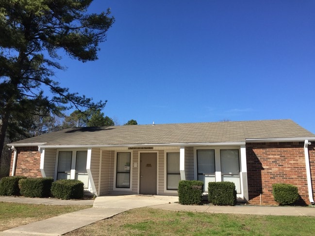
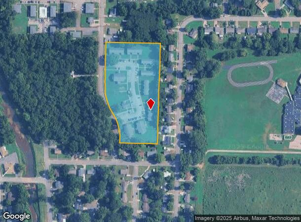
Property Record
4177 Newson Rd Sw, Huntsville, AL 35805
NEARBY LISTINGS FOR SALE OR LEASE
Property Detail
4177 Newson Rd Sw
17-05-15-3-001-023.000
***ERROR ON DEED*** SEC 15 T4S R1W PRT OF THE S 1/2 OF SEC 15 BEG AT A PT W 270.02 FT FR THE CEN OF SD SEC 15 TH S 650 FT TH
Officebuilding
Madison
X
Alabama
01089C0328F
4.84 AC
2025
West Huntsville
2025
Huntsville
002400
Huntsville, AL
1,282 SF
DEMOGRAPHICS near 4177 Newson Rd Sw
1 Mile
3 Mile
5 Mile
2024 Total Population
10,153
41,965
100,682
2029 Population
11,297
46,489
111,799
Pop Growth 2024-2029
+ 11.27%
+ 10.78%
+ 11.04%
Average Age
35
37
39
2024 Total Households
4,091
18,532
45,449
HH Growth 2024-2029
+ 11.71%
+ 11.28%
+ 11.56%
Median Household Inc
$31,850
$42,115
$52,537
Avg Household Size
2.30
2.00
2.00
2024 Avg HH Vehicles
2.00
2.00
2.00
Median Home Value
$75,234
$153,859
$237,939
Median Year Built
1972
1972
1973
Nearby Places
- Restaurants
- Banks
- Shops
- Fitness
- Groceries
PUBLIC TRANSPORTATION
AIRPORT
Huntsville International-Carl T Jones Field
DRIVE
WALK
Distance
Huntsville International-Carl T Jones Field
23 min
14.1 mi
Freight Ports
Port of Mobile
DRIVE
WALK
Distance
Port of Mobile
390 min
355.3 mi
Nearby Properties
Address
Land Use
TOTAL SIZE
Lot Size
Zoning
Address
Land Use
TOTAL SIZE
Lot Size
Zoning
208,719 SF
26.55 AC
Address
Land Use
TOTAL SIZE
Lot Size
Zoning
5,577 SF
12.72 AC
Address
Land Use
TOTAL SIZE
Lot Size
Zoning
184,300 SF
23 AC
Address
Land Use
TOTAL SIZE
Lot Size
Zoning
56,426 SF
13.78 AC
Address
Land Use
TOTAL SIZE
Lot Size
Zoning
78,492 SF
Address
Land Use
TOTAL SIZE
Lot Size
Zoning
25,619 SF
Address
Land Use
TOTAL SIZE
Lot Size
Zoning
4,379 SF
18 AC
Address
Land Use
TOTAL SIZE
Lot Size
Zoning
25,619 SF
Address
Land Use
TOTAL SIZE
Lot Size
Zoning
61,559 SF
5.15 AC
Address
Land Use
TOTAL SIZE
Lot Size
Zoning
76,079 SF
12.71 AC
Address
Land Use
TOTAL SIZE
Lot Size
Zoning
61,712 SF
0.01 AC
Address
Land Use
TOTAL SIZE
Lot Size
Zoning
14,630 SF
13.44 AC
Address
Land Use
TOTAL SIZE
Lot Size
Zoning
57,286 SF
7.30 AC
Address
Land Use
TOTAL SIZE
Lot Size
Zoning
58,809 SF
9.90 AC
Address
Land Use
TOTAL SIZE
Lot Size
Zoning
64,650 SF
2 AC
Address
Land Use
TOTAL SIZE
Lot Size
Zoning
25,619 SF
Address
Land Use
TOTAL SIZE
Lot Size
Zoning
56,100 SF
63.13 AC
Address
Land Use
TOTAL SIZE
Lot Size
Zoning
Address
Land Use
TOTAL SIZE
Lot Size
Zoning
42,231 SF
6.69 AC
Address
Land Use
TOTAL SIZE
Lot Size
Zoning
31,946 SF
16.67 AC
Address
Land Use
TOTAL SIZE
Lot Size
Zoning
50,400 SF
14 AC
Address
Land Use
TOTAL SIZE
Lot Size
Zoning
1,540 SF
20.65 AC
Address
Land Use
TOTAL SIZE
Lot Size
Zoning
19,360 SF
6.24 AC
Address
Land Use
TOTAL SIZE
Lot Size
Zoning
31,775 SF
3.89 AC
Address
Land Use
TOTAL SIZE
Lot Size
Zoning
58,651 SF
3.70 AC
Address
Land Use
TOTAL SIZE
Lot Size
Zoning
18,404 SF
112 AC
Address
Land Use
TOTAL SIZE
Lot Size
Zoning
5,785 SF
12.86 AC
Address
Land Use
TOTAL SIZE
Lot Size
Zoning
2,604 SF
1.92 AC
Address
Land Use
TOTAL SIZE
Lot Size
Zoning
32,290 SF
3.05 AC
Address
Land Use
TOTAL SIZE
Lot Size
Zoning
27,009 SF
5.43 AC
The World's #1 Commercial Real Estate Marketplace
Connect with us
© 2025 CoStar Group
The information above has been obtained from sources believed reliable. While we do not doubt its accuracy we have not verified it and make no guarantee, warranty or representation about it. It is your responsibility to independently confirm its accuracy and completeness. Any projections, opinions, assumptions, or estimates used are for example only and do not represent the current or future performance of the property. The value of this transaction to you depends on tax and other factors which should be evaluated by your tax, financial, and legal advisors. You and your advisors should conduct a careful, independent investigation of the property to determine to your satisfaction the suitability of the property for your needs.