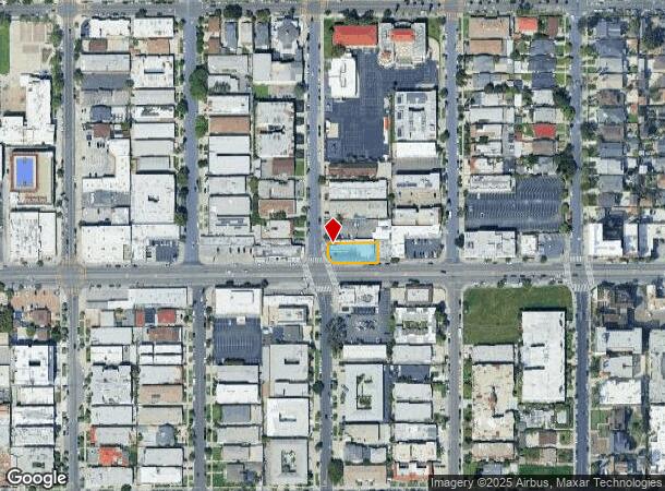
Property Record
268 S Hobart Blvd, Los Angeles, CA 90004
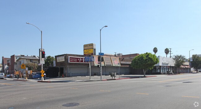
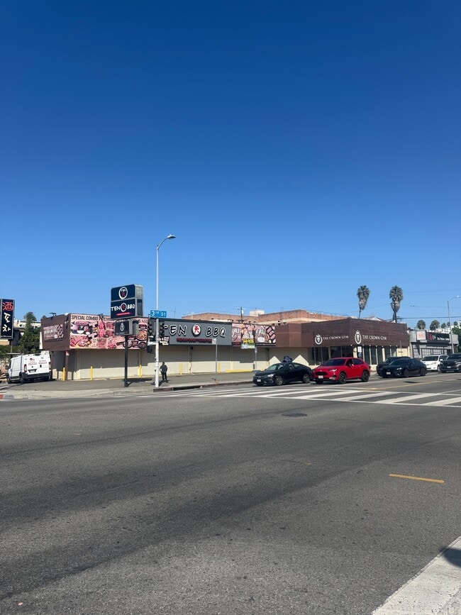

This Property Is For Sale
NEARBY LISTINGS FOR SALE OR LEASE
Property Detail
268 S Hobart Blvd
Los Angeles-Long Beach-Glendale, CA
Norwood Terrace Extension Tract
5517-014-013
NORWOOD TERRACE EXTENSION W 147.63 FT MEASURED ON N LINE OF LOT 91
Storemultistory
Los Angeles
X
California
06037C1610F
91
2024
0.20 AC
2025
Koreatown
211420
Los Angeles
4,277 SF
DEMOGRAPHICS near 268 S Hobart Blvd
1 Mile
3 Mile
5 Mile
2024 Total Population
113,593
617,757
1,157,460
2029 Population
111,852
604,458
1,128,837
Pop Growth 2024-2029
(1.53%)
(2.15%)
(2.47%)
Average Age
39
39
39
2024 Total Households
49,075
258,752
482,607
HH Growth 2024-2029
(1.74%)
(2.16%)
(2.43%)
Median Household Inc
$51,160
$54,640
$60,537
Avg Household Size
2.30
2.30
2.20
2024 Avg HH Vehicles
1.00
1.00
1.00
Median Home Value
$974,098
$1,029,314
$985,223
Median Year Built
1966
1961
1960
Nearby Places
- Restaurants
- Banks
- Shops
- Fitness
- Groceries
PUBLIC TRANSPORTATION
TRANSIT/SUBWAY
Wilshire/Western Station (Purple Line - Los Angeles County Metropolitan Transportation Authority (Metro))
DRIVE
WALK
Distance
Wilshire/Western Station (Purple Line - Los Angeles County Metropolitan Transportation Authority (Metro))
2 min
14 min
0.7 mi
Wilshire/Normandie Station (Purple Line - Los Angeles County Metropolitan Transportation Authority (Metro))
DRIVE
WALK
Distance
Wilshire/Normandie Station (Purple Line - Los Angeles County Metropolitan Transportation Authority (Metro))
2 min
14 min
0.8 mi
COMMUTER RAIL
Los Angeles (Coast Starlight - Amtrak, Pacific Surfliner - Amtrak, Southwest Chief - Amtrak, Texas Eagle - Amtrak)
DRIVE
WALK
Distance
Los Angeles (Coast Starlight - Amtrak, Pacific Surfliner - Amtrak, Southwest Chief - Amtrak, Texas Eagle - Amtrak)
9 min
5.1 mi
Union Station (91 Line - Southern California Regional Rail Authority (Metrolink), Antelope Valley Line - Southern California Regional Rail Authority (Metrolink), Orange County Line - Southern California Regional Rail Authority (Metrolink), Riverside Line - Southern California Regional Rail Authority (Metrolink), San Bernardino Line - Southern California Regional Rail Authority (Metrolink), Ventura County Line - Southern California Regional Rail Authority (Metrolink))
DRIVE
WALK
Distance
Union Station (91 Line - Southern California Regional Rail Authority (Metrolink), Antelope Valley Line - Southern California Regional Rail Authority (Metrolink), Orange County Line - Southern California Regional Rail Authority (Metrolink), Riverside Line - Southern California Regional Rail Authority (Metrolink), San Bernardino Line - Southern California Regional Rail Authority (Metrolink), Ventura County Line - Southern California Regional Rail Authority (Metrolink))
11 min
5.2 mi
AIRPORT
Bob Hope
DRIVE
WALK
Distance
Bob Hope
20 min
11.7 mi
Los Angeles International
DRIVE
WALK
Distance
Los Angeles International
24 min
12.6 mi
Long Beach (Daugherty Field)
DRIVE
WALK
Distance
Long Beach (Daugherty Field)
35 min
25.0 mi
Freight Ports
Port of Long Beach
DRIVE
WALK
Distance
Port of Long Beach
38 min
26.9 mi
Nearby Properties
Address
Land Use
TOTAL SIZE
Lot Size
Zoning
Address
Land Use
TOTAL SIZE
Lot Size
Zoning
930,249 SF
7.39 AC
LAC2
Address
Land Use
TOTAL SIZE
Lot Size
Zoning
108,464 SF
9.17 AC
LALASED
Address
Land Use
TOTAL SIZE
Lot Size
Zoning
969,264 SF
0.94 AC
LAC2
Address
Land Use
TOTAL SIZE
Lot Size
Zoning
1,002,990 SF
8.42 AC
LAC4
Address
Land Use
TOTAL SIZE
Lot Size
Zoning
949,529 SF
1.50 AC
LAC2
Address
Land Use
TOTAL SIZE
Lot Size
Zoning
200,811 SF
4.59 AC
LALASED
Address
Land Use
TOTAL SIZE
Lot Size
Zoning
709,584 SF
1.80 AC
LAPB
Address
Land Use
TOTAL SIZE
Lot Size
Zoning
738,975 SF
2.71 AC
LAC2
Address
Land Use
TOTAL SIZE
Lot Size
Zoning
1,094,768 SF
0.73 AC
LAC2
Address
Land Use
TOTAL SIZE
Lot Size
Zoning
161,046 SF
6.88 AC
LAM1
Address
Land Use
TOTAL SIZE
Lot Size
Zoning
966,466 SF
3.99 AC
LAC2
Address
Land Use
TOTAL SIZE
Lot Size
Zoning
67,126 SF
48.09 AC
LAM1
Address
Land Use
TOTAL SIZE
Lot Size
Zoning
472,363 SF
3.24 AC
LAC4
Address
Land Use
TOTAL SIZE
Lot Size
Zoning
641,453 SF
2.93 AC
LAC4
Address
Land Use
TOTAL SIZE
Lot Size
Zoning
497,377 SF
3.29 AC
LAC4
Address
Land Use
TOTAL SIZE
Lot Size
Zoning
651,289 SF
3.79 AC
LACW
Address
Land Use
TOTAL SIZE
Lot Size
Zoning
1.28 AC
LAC2
Address
Land Use
TOTAL SIZE
Lot Size
Zoning
793,274 SF
7.80 AC
LAR4
Address
Land Use
TOTAL SIZE
Lot Size
Zoning
724,958 SF
5.88 AC
LAC2
Address
Land Use
TOTAL SIZE
Lot Size
Zoning
749,061 SF
2.39 AC
LAC2
Address
Land Use
TOTAL SIZE
Lot Size
Zoning
520,825 SF
2.13 AC
LAC2
Address
Land Use
TOTAL SIZE
Lot Size
Zoning
289,633 SF
1.55 AC
LAP
Address
Land Use
TOTAL SIZE
Lot Size
Zoning
453,182 SF
2.76 AC
LAC4
Address
Land Use
TOTAL SIZE
Lot Size
Zoning
323,927 SF
0.85 AC
LALASED
Address
Land Use
TOTAL SIZE
Lot Size
Zoning
461,090 SF
0.47 AC
LAC2
Address
Land Use
TOTAL SIZE
Lot Size
Zoning
255,868 SF
9.58 AC
WDC2C*
Address
Land Use
TOTAL SIZE
Lot Size
Zoning
289,108 SF
0.57 AC
LAC2
Address
Land Use
TOTAL SIZE
Lot Size
Zoning
746,938 SF
0.98 AC
LAC4
Address
Land Use
TOTAL SIZE
Lot Size
Zoning
679,557 SF
6.41 AC
LAC2
Address
Land Use
TOTAL SIZE
Lot Size
Zoning
786,423 SF
11.74 AC
LAC2
The World's #1 Commercial Real Estate Marketplace
Connect with us
© 2025 CoStar Group
The information above has been obtained from sources believed reliable. While we do not doubt its accuracy we have not verified it and make no guarantee, warranty or representation about it. It is your responsibility to independently confirm its accuracy and completeness. Any projections, opinions, assumptions, or estimates used are for example only and do not represent the current or future performance of the property. The value of this transaction to you depends on tax and other factors which should be evaluated by your tax, financial, and legal advisors. You and your advisors should conduct a careful, independent investigation of the property to determine to your satisfaction the suitability of the property for your needs.