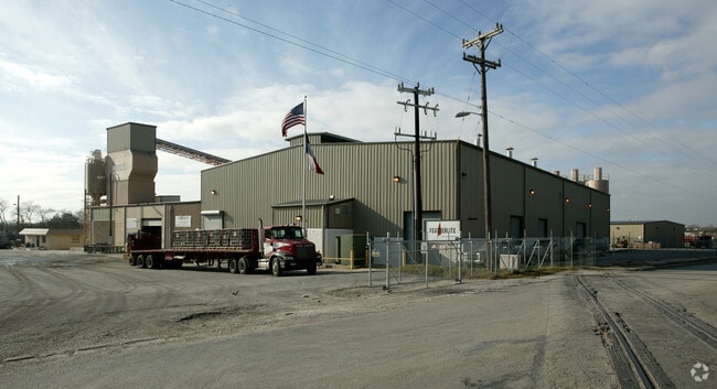
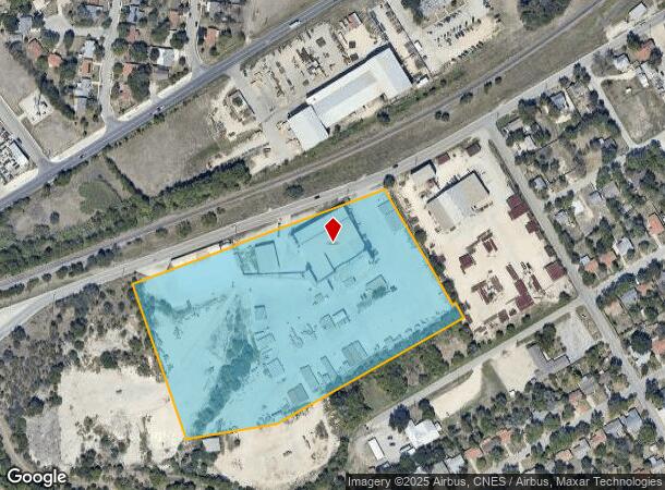
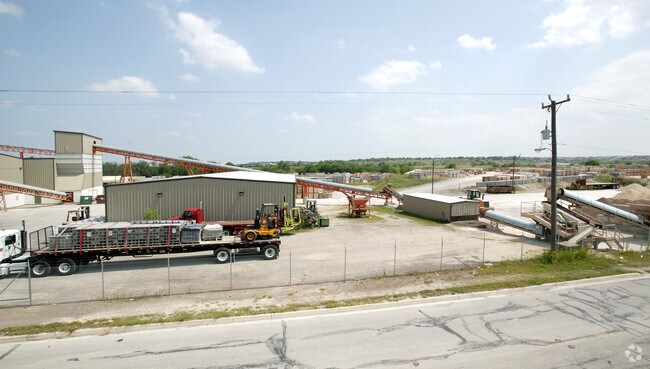
Property Record
418 Gibbs Sprawl Rd, Converse, TX 78109
NEARBY LISTINGS FOR SALE OR LEASE
Property Detail
418 Gibbs Sprawl Rd
San Antonio-New Braunfels, TX
Conv A/S Code
05063-992-0580
CB 5063N BLK 15 LOT 58 CB 5063 P-100 (.1896AC)* FEATHERLITE SUBDIVISION
Lightindustrial
Bexar
X
Texas
48029C0290G
58
2024
10.90 AC
2025
Northeast
131608
San Antonio
61,134 SF
DEMOGRAPHICS near 418 Gibbs Sprawl Rd
1 Mile
3 Mile
5 Mile
2024 Total Population
13,754
103,420
223,563
2029 Population
14,695
110,309
239,436
Pop Growth 2024-2029
+ 6.84%
+ 6.66%
+ 7.10%
Average Age
36
37
37
2024 Total Households
4,652
35,677
78,714
HH Growth 2024-2029
+ 6.88%
+ 6.73%
+ 7.25%
Median Household Inc
$60,346
$69,384
$67,751
Avg Household Size
2.90
2.80
2.80
2024 Avg HH Vehicles
2.00
2.00
2.00
Median Home Value
$161,466
$183,743
$192,114
Median Year Built
1994
1993
1995
Nearby Places
Map Layers
Map Styles
 Street
 Aerial
- Restaurants
- Banks
- Shops
- Fitness
- Groceries
PUBLIC TRANSPORTATION
AIRPORT
San Antonio International
DRIVE
WALK
Distance
San Antonio International
18 min
10.6 mi
SALE & LEASE HISTORY
LISTING DATE
SALE/LEASE

Apr 03, 2019
For Sale
Nearby Properties
Address
Land Use
TOTAL SIZE
Lot Size
Zoning
Address
Land Use
TOTAL SIZE
Lot Size
Zoning
727,299 SF
47.68 AC
Address
Land Use
TOTAL SIZE
Lot Size
Zoning
347,943 SF
10.07 AC
Address
Land Use
TOTAL SIZE
Lot Size
Zoning
223,185 SF
16.85 AC
Address
Land Use
TOTAL SIZE
Lot Size
Zoning
116,536 SF
13.84 AC
Address
Land Use
TOTAL SIZE
Lot Size
Zoning
110,605 SF
19.95 AC
Address
Land Use
TOTAL SIZE
Lot Size
Zoning
218,379 SF
9.65 AC
Address
Land Use
TOTAL SIZE
Lot Size
Zoning
277,887 SF
14.14 AC
Address
Land Use
TOTAL SIZE
Lot Size
Zoning
249,633 SF
7.04 AC
Address
Land Use
TOTAL SIZE
Lot Size
Zoning
251,707 SF
20.22 AC
Address
Land Use
TOTAL SIZE
Lot Size
Zoning
230,659 SF
15.48 AC
Address
Land Use
TOTAL SIZE
Lot Size
Zoning
200,940 SF
10.31 AC
Address
Land Use
TOTAL SIZE
Lot Size
Zoning
198,868 SF
15.15 AC
Address
Land Use
TOTAL SIZE
Lot Size
Zoning
271,018 SF
13.75 AC
Address
Land Use
TOTAL SIZE
Lot Size
Zoning
190,134 SF
10.54 AC
Address
Land Use
TOTAL SIZE
Lot Size
Zoning
190,717 SF
9.99 AC
Address
Land Use
TOTAL SIZE
Lot Size
Zoning
183,611 SF
10.13 AC
Address
Land Use
TOTAL SIZE
Lot Size
Zoning
342,612 SF
28.49 AC
Address
Land Use
TOTAL SIZE
Lot Size
Zoning
186,055 SF
17.44 AC
Address
Land Use
TOTAL SIZE
Lot Size
Zoning
205,469 SF
12.55 AC
Address
Land Use
TOTAL SIZE
Lot Size
Zoning
2,129 SF
46.59 AC
Address
Land Use
TOTAL SIZE
Lot Size
Zoning
124,690 SF
24.47 AC
Address
Land Use
TOTAL SIZE
Lot Size
Zoning
276,006 SF
13 AC
Address
Land Use
TOTAL SIZE
Lot Size
Zoning
17,653 SF
61.92 AC
Address
Land Use
TOTAL SIZE
Lot Size
Zoning
134,157 SF
5.95 AC
Address
Land Use
TOTAL SIZE
Lot Size
Zoning
120,226 SF
12.25 AC
Address
Land Use
TOTAL SIZE
Lot Size
Zoning
205,372 SF
21.38 AC
Address
Land Use
TOTAL SIZE
Lot Size
Zoning
2,747 SF
74.97 AC
Address
Land Use
TOTAL SIZE
Lot Size
Zoning
2,676 SF
37.39 AC
Address
Land Use
TOTAL SIZE
Lot Size
Zoning
66,540 SF
7.53 AC
Address
Land Use
TOTAL SIZE
Lot Size
Zoning
242,802 SF
9.42 AC
The World's #1 Commercial Real Estate Marketplace
Connect with us
© 2026 CoStar Group
The information above has been obtained from sources believed reliable. While we do not doubt its accuracy we have not verified it and make no guarantee, warranty or representation about it. It is your responsibility to independently confirm its accuracy and completeness. Any projections, opinions, assumptions, or estimates used are for example only and do not represent the current or future performance of the property. The value of this transaction to you depends on tax and other factors which should be evaluated by your tax, financial, and legal advisors. You and your advisors should conduct a careful, independent investigation of the property to determine to your satisfaction the suitability of the property for your needs.