Property Record
418 N 9Th Ave, Greeley, CO 80631
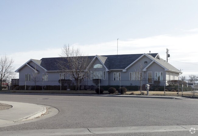

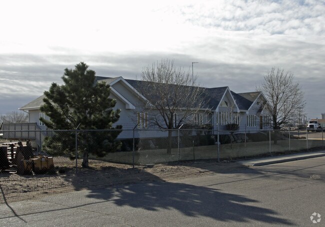
Property Detail
418 N 9Th Ave
Greeley, CO
GR L4 SHUPE SUB & PT BLK194 & PT L4-5-6 BLK36 CLAYTON PARK BEG NE COR L4 BLK36 CLAYTON PARK N185 E39.24 TO WLY ROW LN HWY 85 S08D45E 318.75 S71D0E 2.97 S08D45E 78.34 S95.4 W130 N303.84 E33.1 TO POB EXC PT L5 & 6 BLK36 CLAYTON PARK DESC AS BEG SW COR
R8926501
Weld
Warehouse
Colorado
AE The base floodplain where base flood elevations are provided. AE Zones are now used on new format FIRMs instead of A1-A30 Zones.
4
2024
1.17 AC
2025
Weld County
000600
Denver
5,364 SF
NEARBY LISTINGS FOR SALE OR LEASE
DEMOGRAPHICS near 418 N 9Th Ave
1 mile
3 mile
5 mile
2024 Total Population
6,827
62,211
125,908
2029 Population
8,041
73,218
148,299
Pop Growth 2024-2029
+ 17.78%
+ 17.69%
+ 17.78%
Average Age
36
35
36
2024 Total Households
2,259
21,086
44,681
HH Growth 2024-2029
+ 18.90%
+ 18.75%
+ 18.54%
Median Household Inc
$41,900
$48,953
$59,127
Avg Household Size
2.60
2.70
2.70
2024 Avg HH Vehicles
2.00
2.00
2.00
Median Home Value
$306,757
$285,189
$330,608
Median Year Built
1974
1973
1983
Nearby Places
Map Layers
Map Styles
 Street
 Aerial
Transit
 Traffic
 Biking
Places
Listings with unknown addresses are not visible on the map
- Restaurants
- Banks
- Shops
- Fitness
- Groceries
Nearby Properties
Address
Land Use
TOTAL SIZE
Lot Size
Zoning
Address
Land Use
TOTAL SIZE
Lot Size
Zoning
1,682,342 SF
134.62 AC
Address
Land Use
TOTAL SIZE
Lot Size
Zoning
1,181,203 SF
23.26 AC
Address
Land Use
TOTAL SIZE
Lot Size
Zoning
689,580 SF
65.15 AC
Address
Land Use
TOTAL SIZE
Lot Size
Zoning
393,166 SF
4.53 AC
Address
Land Use
TOTAL SIZE
Lot Size
Zoning
536,281 SF
33.91 AC
Address
Land Use
TOTAL SIZE
Lot Size
Zoning
237,575 SF
10.77 AC
Address
Land Use
TOTAL SIZE
Lot Size
Zoning
113,715 SF
9.42 AC
Address
Land Use
TOTAL SIZE
Lot Size
Zoning
78.18 AC
Address
Land Use
TOTAL SIZE
Lot Size
Zoning
83,032 SF
9.23 AC
Address
Land Use
TOTAL SIZE
Lot Size
Zoning
99,348 SF
5.85 AC
Address
Land Use
TOTAL SIZE
Lot Size
Zoning
34,697 SF
55.28 AC
Address
Land Use
TOTAL SIZE
Lot Size
Zoning
700,277 SF
16.35 AC
Address
Land Use
TOTAL SIZE
Lot Size
Zoning
79,313 SF
23.46 AC
Address
Land Use
TOTAL SIZE
Lot Size
Zoning
63,960 SF
3.67 AC
Address
Land Use
TOTAL SIZE
Lot Size
Zoning
239,925 SF
6.06 AC
Address
Land Use
TOTAL SIZE
Lot Size
Zoning
127,822 SF
1.38 AC
Address
Land Use
TOTAL SIZE
Lot Size
Zoning
132,968 SF
1.24 AC
Address
Land Use
TOTAL SIZE
Lot Size
Zoning
82,759 SF
2.05 AC
Address
Land Use
TOTAL SIZE
Lot Size
Zoning
145,184 SF
19 AC
Address
Land Use
TOTAL SIZE
Lot Size
Zoning
198,845 SF
16.02 AC
Address
Land Use
TOTAL SIZE
Lot Size
Zoning
88,620 SF
5.11 AC
Address
Land Use
TOTAL SIZE
Lot Size
Zoning
128,054 SF
Address
Land Use
TOTAL SIZE
Lot Size
Zoning
178,873 SF
4.13 AC
Address
Land Use
TOTAL SIZE
Lot Size
Zoning
114,879 SF
27.73 AC
Address
Land Use
TOTAL SIZE
Lot Size
Zoning
52,041 SF
4.36 AC
Address
Land Use
TOTAL SIZE
Lot Size
Zoning
253,204 SF
25.82 AC
Address
Land Use
TOTAL SIZE
Lot Size
Zoning
124,456 SF
10.72 AC
Address
Land Use
TOTAL SIZE
Lot Size
Zoning
72,400 SF
19.55 AC
Address
Land Use
TOTAL SIZE
Lot Size
Zoning
87,504 SF
8.13 AC
Address
Land Use
TOTAL SIZE
Lot Size
Zoning
49,488 SF
46.63 AC
The World's #1 Commercial Real Estate Marketplace
Connect with us
© 2026 CoStar Group
The information above has been obtained from sources believed reliable. While we do not doubt its accuracy we have not verified it and make no guarantee, warranty or representation about it. It is your responsibility to independently confirm its accuracy and completeness. Any projections, opinions, assumptions, or estimates used are for example only and do not represent the current or future performance of the property. The value of this transaction to you depends on tax and other factors which should be evaluated by your tax, financial, and legal advisors. You and your advisors should conduct a careful, independent investigation of the property to determine to your satisfaction the suitability of the property for your needs.