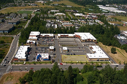
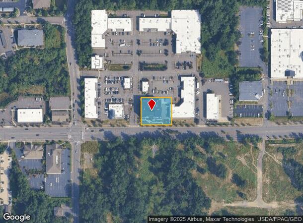
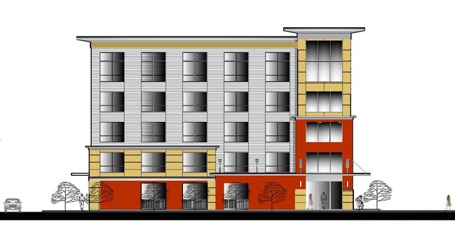
Property Record
418 W Bakerview Rd, Bellingham, WA 98226
NEARBY LISTINGS FOR SALE OR LEASE
Property Detail
418 W Bakerview Rd
Bellingham, WA
2Nd Am Bakerview Square Lla Phase 2
380212-341011-0000
LOT B 2ND AM BAKERVIEW SQUARE LLA PHASE 2 AS REC AF 2150901814
Multifamilydwelling
Whatcom
X
Washington
53073C1211E
b
2024
0.51 AC
2024
Bellingham/Northwest
000203
Other Market Areas
48,124 SF
DEMOGRAPHICS near 418 W Bakerview Rd
1 Mile
3 Mile
5 Mile
2024 Total Population
12,035
46,683
102,899
2029 Population
12,717
48,872
107,450
Pop Growth 2024-2029
+ 5.67%
+ 4.69%
+ 4.42%
Average Age
41
40
39
2024 Total Households
5,719
20,888
42,993
HH Growth 2024-2029
+ 5.79%
+ 4.79%
+ 4.63%
Median Household Inc
$49,911
$58,751
$63,466
Avg Household Size
2.00
2.10
2.20
2024 Avg HH Vehicles
2.00
2.00
2.00
Median Home Value
$384,999
$480,441
$569,662
Median Year Built
1997
1989
1987
Nearby Places
- Restaurants
- Banks
- Shops
- Fitness
- Groceries
SALE & LEASE HISTORY
LISTING DATE
SALE/LEASE

Oct 26, 2017
For Sale
Apr 11, 2017
For Sale
Nearby Properties
Address
Land Use
TOTAL SIZE
Lot Size
Zoning
Address
Land Use
TOTAL SIZE
Lot Size
Zoning
507,750 SF
15.05 AC
IN
Address
Land Use
TOTAL SIZE
Lot Size
Zoning
203,749 SF
162.97 AC
CWF
Address
Land Use
TOTAL SIZE
Lot Size
Zoning
111,507 SF
845.26 AC
AO
Address
Land Use
TOTAL SIZE
Lot Size
Zoning
259,312 SF
2.76 AC
P
Address
Land Use
TOTAL SIZE
Lot Size
Zoning
330,497 SF
30.17 AC
P
Address
Land Use
TOTAL SIZE
Lot Size
Zoning
46,850 SF
129.61 AC
RMPLAN
Address
Land Use
TOTAL SIZE
Lot Size
Zoning
151,677 SF
12.84 AC
PCM
Address
Land Use
TOTAL SIZE
Lot Size
Zoning
292,744 SF
9.14 AC
LIL
Address
Land Use
TOTAL SIZE
Lot Size
Zoning
177,740 SF
7.42 AC
PC
Address
Land Use
TOTAL SIZE
Lot Size
Zoning
256,155 SF
36.63 AC
PCW
Address
Land Use
TOTAL SIZE
Lot Size
Zoning
239,925 SF
17.46 AC
PC
Address
Land Use
TOTAL SIZE
Lot Size
Zoning
112,423 SF
3.23 AC
RS
Address
Land Use
TOTAL SIZE
Lot Size
Zoning
89,174 SF
3.74 AC
PCLI
Address
Land Use
TOTAL SIZE
Lot Size
Zoning
218,295 SF
13.22 AC
PRM2.5
Address
Land Use
TOTAL SIZE
Lot Size
Zoning
148,945 SF
1.51 AC
PCM
Address
Land Use
TOTAL SIZE
Lot Size
Zoning
239,299 SF
7.73 AC
PRM2.5
Address
Land Use
TOTAL SIZE
Lot Size
Zoning
459,793 SF
25.47 AC
PREC
Address
Land Use
TOTAL SIZE
Lot Size
Zoning
152,381 SF
6.05 AC
PC
Address
Land Use
TOTAL SIZE
Lot Size
Zoning
159,238 SF
1.54 AC
PICR
Address
Land Use
TOTAL SIZE
Lot Size
Zoning
153,456 SF
5.86 AC
LIL
Address
Land Use
TOTAL SIZE
Lot Size
Zoning
95,263 SF
2.84 AC
PIN
Address
Land Use
TOTAL SIZE
Lot Size
Zoning
201,508 SF
13.73 AC
P
Address
Land Use
TOTAL SIZE
Lot Size
Zoning
162,443 SF
8.01 AC
PI
Address
Land Use
TOTAL SIZE
Lot Size
Zoning
84,006 SF
16.20 AC
PICR4
Address
Land Use
TOTAL SIZE
Lot Size
Zoning
146,187 SF
6.44 AC
PC
Address
Land Use
TOTAL SIZE
Lot Size
Zoning
158,200 SF
1.34 AC
PICR
Address
Land Use
TOTAL SIZE
Lot Size
Zoning
168,279 SF
2.50 AC
PCM2.5
Address
Land Use
TOTAL SIZE
Lot Size
Zoning
178,131 SF
7.42 AC
URM18
Address
Land Use
TOTAL SIZE
Lot Size
Zoning
662,133 SF
118.82 AC
I
Address
Land Use
TOTAL SIZE
Lot Size
Zoning
143,818 SF
6.75 AC
RM2.0
The World's #1 Commercial Real Estate Marketplace
Connect with us
© 2025 CoStar Group
The information above has been obtained from sources believed reliable. While we do not doubt its accuracy we have not verified it and make no guarantee, warranty or representation about it. It is your responsibility to independently confirm its accuracy and completeness. Any projections, opinions, assumptions, or estimates used are for example only and do not represent the current or future performance of the property. The value of this transaction to you depends on tax and other factors which should be evaluated by your tax, financial, and legal advisors. You and your advisors should conduct a careful, independent investigation of the property to determine to your satisfaction the suitability of the property for your needs.