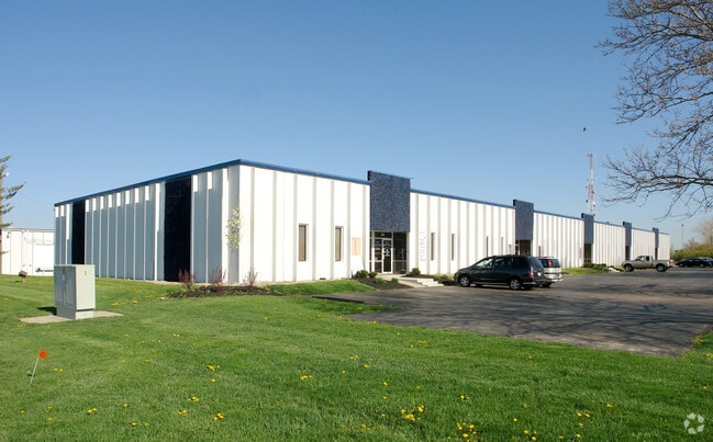
Property Record
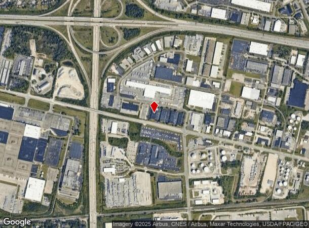
801 Phillipi Rd, Columbus, OH 43228

NEARBY LISTINGS FOR SALE OR LEASE
Property Detail
801 Phillipi Rd
Columbus, OH
Brookshire South
010-005132
801 PHILLIPI RD ENTRY 3316-7325 7.795 ACRES
Warehouse
Franklin
X
Ohio
39049C0301K
163
2024
7.80 AC
2024
Downtown West
008210
Columbus
120,679 SF
DEMOGRAPHICS near 801 Phillipi Rd
1 Mile
3 Mile
5 Mile
2024 Total Population
3,634
104,252
257,449
2029 Population
3,675
104,872
257,865
Pop Growth 2024-2029
+ 1.13%
+ 0.59%
+ 0.16%
Average Age
35
36
37
2024 Total Households
1,469
41,231
104,298
HH Growth 2024-2029
+ 1.02%
+ 0.46%
+ 0.05%
Median Household Inc
$70,468
$60,553
$68,557
Avg Household Size
2.40
2.50
2.40
2024 Avg HH Vehicles
2.00
2.00
2.00
Median Home Value
$235,892
$197,524
$237,918
Median Year Built
1990
1981
1978
Nearby Places
- Restaurants
- Banks
- Shops
- Fitness
- Groceries
PUBLIC TRANSPORTATION
AIRPORT
John Glenn Columbus International
DRIVE
WALK
Distance
John Glenn Columbus International
20 min
13.5 mi
Rickenbacker International
DRIVE
WALK
Distance
Rickenbacker International
29 min
18.8 mi
Freight Ports
Port of Toledo
DRIVE
WALK
Distance
Port of Toledo
185 min
136.1 mi
SALE & LEASE HISTORY
LISTING DATE
SALE/LEASE

Sep 25, 2016
For Lease
Mar 24, 2022
For Lease
Jan 23, 2023
For Lease
Feb 21, 2025
For Lease
Aug 23, 2017
For Lease
Nearby Properties
Address
Land Use
TOTAL SIZE
Lot Size
Zoning
Address
Land Use
TOTAL SIZE
Lot Size
Zoning
1,215,421 SF
108.07 AC
Address
Land Use
TOTAL SIZE
Lot Size
Zoning
642,900 SF
21.84 AC
Address
Land Use
TOTAL SIZE
Lot Size
Zoning
269,165 SF
7 AC
Address
Land Use
TOTAL SIZE
Lot Size
Zoning
555,347 SF
24.77 AC
Address
Land Use
TOTAL SIZE
Lot Size
Zoning
961,554 SF
75.09 AC
Address
Land Use
TOTAL SIZE
Lot Size
Zoning
257,723 SF
38.06 AC
Address
Land Use
TOTAL SIZE
Lot Size
Zoning
87,654 SF
45.30 AC
Address
Land Use
TOTAL SIZE
Lot Size
Zoning
329,215 SF
8.33 AC
Address
Land Use
TOTAL SIZE
Lot Size
Zoning
34,521 SF
29.23 AC
Address
Land Use
TOTAL SIZE
Lot Size
Zoning
538,680 SF
32.49 AC
Address
Land Use
TOTAL SIZE
Lot Size
Zoning
50,837 SF
10.12 AC
Address
Land Use
TOTAL SIZE
Lot Size
Zoning
70,995 SF
38.78 AC
Address
Land Use
TOTAL SIZE
Lot Size
Zoning
255,902 SF
8.15 AC
Address
Land Use
TOTAL SIZE
Lot Size
Zoning
156,839 SF
48.45 AC
Address
Land Use
TOTAL SIZE
Lot Size
Zoning
155,280 SF
9.42 AC
Address
Land Use
TOTAL SIZE
Lot Size
Zoning
110,344 SF
19.06 AC
Address
Land Use
TOTAL SIZE
Lot Size
Zoning
566,334 SF
58.62 AC
Address
Land Use
TOTAL SIZE
Lot Size
Zoning
25,368 SF
27.23 AC
Address
Land Use
TOTAL SIZE
Lot Size
Zoning
96,602 SF
10.78 AC
Address
Land Use
TOTAL SIZE
Lot Size
Zoning
24,736 SF
29.55 AC
Address
Land Use
TOTAL SIZE
Lot Size
Zoning
108,828 SF
23.51 AC
Address
Land Use
TOTAL SIZE
Lot Size
Zoning
143.78 AC
Address
Land Use
TOTAL SIZE
Lot Size
Zoning
293,744 SF
20.12 AC
Address
Land Use
TOTAL SIZE
Lot Size
Zoning
157,875 SF
8.51 AC
Address
Land Use
TOTAL SIZE
Lot Size
Zoning
62,400 SF
9.02 AC
Address
Land Use
TOTAL SIZE
Lot Size
Zoning
759,600 SF
23.75 AC
Address
Land Use
TOTAL SIZE
Lot Size
Zoning
138,003 SF
2.94 AC
Address
Land Use
TOTAL SIZE
Lot Size
Zoning
131,116 SF
15.30 AC
Address
Land Use
TOTAL SIZE
Lot Size
Zoning
202,330 SF
18.89 AC
Address
Land Use
TOTAL SIZE
Lot Size
Zoning
178,452 SF
34.84 AC
The World's #1 Commercial Real Estate Marketplace
Connect with us
© 2025 CoStar Group
The information above has been obtained from sources believed reliable. While we do not doubt its accuracy we have not verified it and make no guarantee, warranty or representation about it. It is your responsibility to independently confirm its accuracy and completeness. Any projections, opinions, assumptions, or estimates used are for example only and do not represent the current or future performance of the property. The value of this transaction to you depends on tax and other factors which should be evaluated by your tax, financial, and legal advisors. You and your advisors should conduct a careful, independent investigation of the property to determine to your satisfaction the suitability of the property for your needs.