Property Record
4181 Mcbrayer Rd, Oakwood, GA 30566
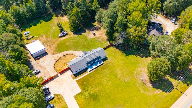
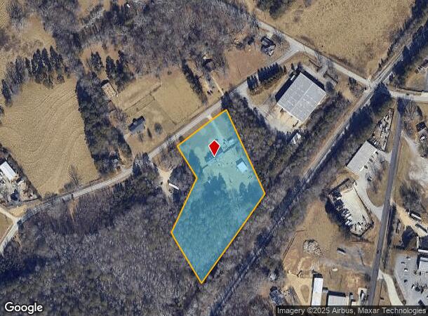
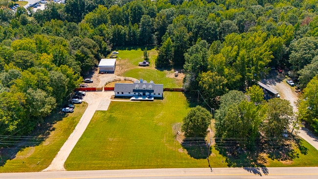

This Property Is For Sale
NEARBY LISTINGS FOR SALE OR LEASE
Property Detail
4181 Mcbrayer Rd
Gainesville, GA
Hall
08-00067-00-003B
Georgia
Sfr
4.24 AC
X
I-985/Gainesville
13139C0284G
Atlanta
1,704 SF
DEMOGRAPHICS near 4181 Mcbrayer Rd
1 Mile
3 Mile
5 Mile
2024 Total Population
1,759
30,876
72,575
2029 Population
1,941
33,759
78,630
Pop Growth 2024-2029
+ 10.35%
+ 9.34%
+ 8.34%
Average Age
36
39
40
2024 Total Households
639
11,556
25,715
HH Growth 2024-2029
+ 10.49%
+ 9.35%
+ 8.44%
Median Household Inc
$65,454
$81,151
$86,405
Avg Household Size
2.70
2.60
2.80
2024 Avg HH Vehicles
2.00
2.00
2.00
Median Home Value
$336,220
$341,298
$364,412
Median Year Built
1989
2000
1998
Nearby Places
- Restaurants
- Banks
- Shops
- Fitness
- Groceries
PUBLIC TRANSPORTATION
COMMUTER RAIL
DRIVE
WALK
Distance
15 min
8.7 mi
Nearby Properties
Address
Land Use
TOTAL SIZE
Lot Size
Zoning
Address
Land Use
TOTAL SIZE
Lot Size
Zoning
5,760 SF
38.07 AC
R-III
Address
Land Use
TOTAL SIZE
Lot Size
Zoning
102,060 SF
31.90 AC
R-1I/H-B
Address
Land Use
TOTAL SIZE
Lot Size
Zoning
85,900 SF
25.29 AC
H-B
Address
Land Use
TOTAL SIZE
Lot Size
Zoning
164,815 SF
29.93 AC
R-IV
Address
Land Use
TOTAL SIZE
Lot Size
Zoning
150,738 SF
43.34 AC
M-1
Address
Land Use
TOTAL SIZE
Lot Size
Zoning
656,200 SF
70.29 AC
M-1
Address
Land Use
TOTAL SIZE
Lot Size
Zoning
112,734 SF
32.02 AC
R-4
Address
Land Use
TOTAL SIZE
Lot Size
Zoning
92,448 SF
24.25 AC
PUD
Address
Land Use
TOTAL SIZE
Lot Size
Zoning
144,744 SF
35.47 AC
C-2
Address
Land Use
TOTAL SIZE
Lot Size
Zoning
3,881 SF
27.86 AC
R-IV
Address
Land Use
TOTAL SIZE
Lot Size
Zoning
45,900 SF
6.99 AC
PRD
Address
Land Use
TOTAL SIZE
Lot Size
Zoning
342,720 SF
22.95 AC
PUD
Address
Land Use
TOTAL SIZE
Lot Size
Zoning
447,120 SF
35 AC
M-1
Address
Land Use
TOTAL SIZE
Lot Size
Zoning
174,720 SF
50.23 AC
M-2
Address
Land Use
TOTAL SIZE
Lot Size
Zoning
351,550 SF
26.91 AC
M-2
Address
Land Use
TOTAL SIZE
Lot Size
Zoning
104,340 SF
42.22 AC
INST
Address
Land Use
TOTAL SIZE
Lot Size
Zoning
175,622 SF
20.22 AC
M-2
Address
Land Use
TOTAL SIZE
Lot Size
Zoning
304,844 SF
37.58 AC
M-2
Address
Land Use
TOTAL SIZE
Lot Size
Zoning
1,580 SF
15.85 AC
PUD
Address
Land Use
TOTAL SIZE
Lot Size
Zoning
269,130 SF
25.34 AC
M-1
Address
Land Use
TOTAL SIZE
Lot Size
Zoning
225,378 SF
24.42 AC
M-1
Address
Land Use
TOTAL SIZE
Lot Size
Zoning
515,468 SF
92 AC
I-1
Address
Land Use
TOTAL SIZE
Lot Size
Zoning
3,195 SF
80.04 AC
AR-1
Address
Land Use
TOTAL SIZE
Lot Size
Zoning
213,480 SF
13.16 AC
M-1
Address
Land Use
TOTAL SIZE
Lot Size
Zoning
255,201 SF
21.75 AC
M-1
Address
Land Use
TOTAL SIZE
Lot Size
Zoning
172,114 SF
43.32 AC
M-2
Address
Land Use
TOTAL SIZE
Lot Size
Zoning
192,177 SF
12.43 AC
PRD
Address
Land Use
TOTAL SIZE
Lot Size
Zoning
183,700 SF
19.94 AC
M-1
Address
Land Use
TOTAL SIZE
Lot Size
Zoning
58.61 AC
INST
Address
Land Use
TOTAL SIZE
Lot Size
Zoning
201,322 SF
10 AC
M-1
The World's #1 Commercial Real Estate Marketplace
Connect with us
© 2025 CoStar Group
The information above has been obtained from sources believed reliable. While we do not doubt its accuracy we have not verified it and make no guarantee, warranty or representation about it. It is your responsibility to independently confirm its accuracy and completeness. Any projections, opinions, assumptions, or estimates used are for example only and do not represent the current or future performance of the property. The value of this transaction to you depends on tax and other factors which should be evaluated by your tax, financial, and legal advisors. You and your advisors should conduct a careful, independent investigation of the property to determine to your satisfaction the suitability of the property for your needs.