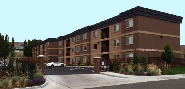
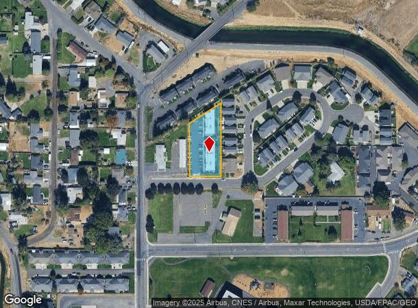
Property Record
4188 Nola Loop Rd, Yakima, WA 98901
NEARBY LISTINGS FOR SALE OR LEASE
Property Detail
4188 Nola Loop Rd
Yakima, WA
Sp 90-005
191315-33445
SECTION 15 TOWNSHIP 13 RANGE 19 QUARTER SW: SP 90-005 LOT 2
Multifamilydwelling
Yakima
X
Washington
53077C1052D
2
2025
0.72 AC
2025
East Yakima County
001602
Yakima
6,193 SF
DEMOGRAPHICS near 4188 Nola Loop Rd
1 Mile
3 Mile
5 Mile
2024 Total Population
6,617
26,846
80,573
2029 Population
6,693
27,020
80,801
Pop Growth 2024-2029
+ 1.15%
+ 0.65%
+ 0.28%
Average Age
40
35
35
2024 Total Households
2,635
9,285
27,500
HH Growth 2024-2029
+ 1.14%
+ 0.65%
+ 0.23%
Median Household Inc
$71,999
$48,782
$48,666
Avg Household Size
2.40
2.80
2.80
2024 Avg HH Vehicles
2.00
2.00
2.00
Median Home Value
$318,163
$251,280
$212,821
Median Year Built
1995
1976
1970
Nearby Places
Map Layers
Map Styles
 Street
 Aerial
- Restaurants
- Banks
- Shops
- Fitness
- Groceries
PUBLIC TRANSPORTATION
AIRPORT
Yakima Air Trml/McAllister Field
DRIVE
WALK
Distance
Yakima Air Trml/McAllister Field
17 min
7.0 mi
Freight Ports
Port of Tacoma
DRIVE
WALK
Distance
Port of Tacoma
185 min
157.1 mi
Nearby Properties
Address
Land Use
TOTAL SIZE
Lot Size
Zoning
Address
Land Use
TOTAL SIZE
Lot Size
Zoning
197,341 SF
36.70 AC
GC
Address
Land Use
TOTAL SIZE
Lot Size
Zoning
87,068 SF
2.89 AC
CBD
Address
Land Use
TOTAL SIZE
Lot Size
Zoning
106,878 SF
3.46 AC
RD
Address
Land Use
TOTAL SIZE
Lot Size
Zoning
129,042 SF
6.53 AC
R3
Address
Land Use
TOTAL SIZE
Lot Size
Zoning
82,436 SF
11 AC
RD
Address
Land Use
TOTAL SIZE
Lot Size
Zoning
121,488 SF
5.97 AC
R3
Address
Land Use
TOTAL SIZE
Lot Size
Zoning
100,992 SF
9.15 AC
RD
Address
Land Use
TOTAL SIZE
Lot Size
Zoning
91,856 SF
9.17 AC
RD
Address
Land Use
TOTAL SIZE
Lot Size
Zoning
56,505 SF
2.75 AC
C1
Address
Land Use
TOTAL SIZE
Lot Size
Zoning
97,056 SF
5.80 AC
R3
Address
Land Use
TOTAL SIZE
Lot Size
Zoning
197,263 SF
18.08 AC
C1
Address
Land Use
TOTAL SIZE
Lot Size
Zoning
84,714 SF
4.40 AC
R3
Address
Land Use
TOTAL SIZE
Lot Size
Zoning
83,856 SF
4.23 AC
R3
Address
Land Use
TOTAL SIZE
Lot Size
Zoning
94,724 SF
0.79 AC
CBD
Address
Land Use
TOTAL SIZE
Lot Size
Zoning
73,917 SF
1.01 AC
CBD
Address
Land Use
TOTAL SIZE
Lot Size
Zoning
64,593 SF
10.02 AC
R1
Address
Land Use
TOTAL SIZE
Lot Size
Zoning
76,160 SF
39.51 AC
M1
Address
Land Use
TOTAL SIZE
Lot Size
Zoning
69.87 AC
SR
Address
Land Use
TOTAL SIZE
Lot Size
Zoning
204,600 SF
12.54 AC
B2
Address
Land Use
TOTAL SIZE
Lot Size
Zoning
9,121 SF
0.22 AC
C1
Address
Land Use
TOTAL SIZE
Lot Size
Zoning
163,130 SF
1.95 AC
CBD
Address
Land Use
TOTAL SIZE
Lot Size
Zoning
427,713 SF
22.43 AC
M1
Address
Land Use
TOTAL SIZE
Lot Size
Zoning
142,546 SF
0.55 AC
CBD
Address
Land Use
TOTAL SIZE
Lot Size
Zoning
50,919 SF
1.99 AC
C1
Address
Land Use
TOTAL SIZE
Lot Size
Zoning
141,696 SF
6.42 AC
M1
Address
Land Use
TOTAL SIZE
Lot Size
Zoning
70,164 SF
16.03 AC
M1
Address
Land Use
TOTAL SIZE
Lot Size
Zoning
87,258 SF
6.64 AC
R1
Address
Land Use
TOTAL SIZE
Lot Size
Zoning
56,973 SF
6.06 AC
R3
Address
Land Use
TOTAL SIZE
Lot Size
Zoning
115,885 SF
7.83 AC
RD
The World's #1 Commercial Real Estate Marketplace
Connect with us
© 2026 CoStar Group
The information above has been obtained from sources believed reliable. While we do not doubt its accuracy we have not verified it and make no guarantee, warranty or representation about it. It is your responsibility to independently confirm its accuracy and completeness. Any projections, opinions, assumptions, or estimates used are for example only and do not represent the current or future performance of the property. The value of this transaction to you depends on tax and other factors which should be evaluated by your tax, financial, and legal advisors. You and your advisors should conduct a careful, independent investigation of the property to determine to your satisfaction the suitability of the property for your needs.