Property Record
4189 S 300 W, Ogden, UT 84405

NEARBY LISTINGS FOR SALE OR LEASE
Property Detail
4189 S 300 W
Ogden-Clearfield, UT
Greenhill At Rivderdale Subdivision
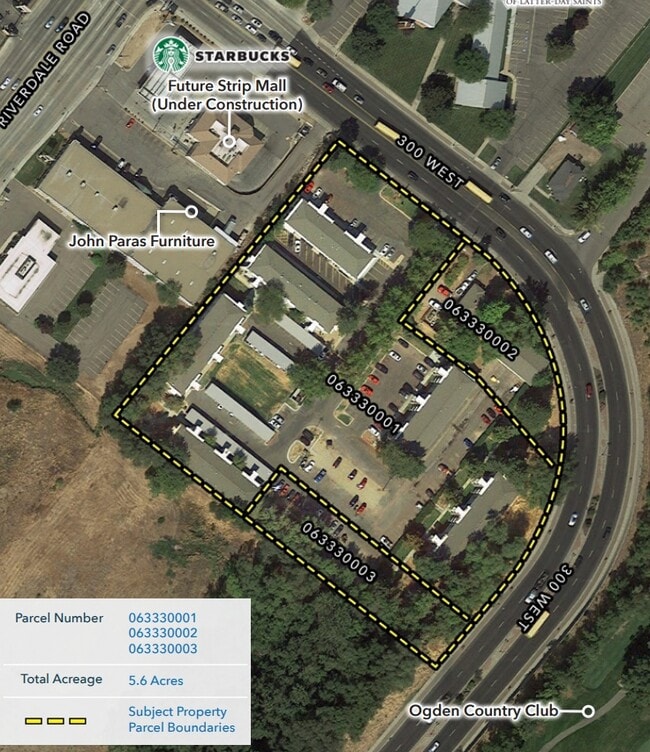
06-333-0001
ALL OF LOT 1, GREENHILL AT RIVERDALE SUBDIVISION, RIVERDALE CITY, WEBER COUNTY, UTAH.
Highriseapartments
Weber
X
Utah
49057C0436G
1
2025
4.24 AC
2025
Riverdale
210512
Salt Lake City
10,440 SF
DEMOGRAPHICS near 4189 S 300 W
1 Mile
3 Mile
5 Mile
2024 Total Population
12,099
84,353
178,889
2029 Population
13,020
90,543
191,900
Pop Growth 2024-2029
+ 7.61%
+ 7.34%
+ 7.27%
Average Age
35
36
36
2024 Total Households
4,274
31,148
63,487
HH Growth 2024-2029
+ 7.84%
+ 7.58%
+ 7.49%
Median Household Inc
$59,448
$60,787
$66,394
Avg Household Size
2.80
2.60
2.70
2024 Avg HH Vehicles
2.00
2.00
2.00
Median Home Value
$308,733
$329,686
$338,548
Median Year Built
1970
1970
1977
Nearby Places
Map Layers
Map Styles
 Street
 Aerial
- Restaurants
- Banks
- Shops
- Fitness
- Groceries
PUBLIC TRANSPORTATION
COMMUTER RAIL
Ogden (FrontRunner North - Utah Transit Authority (UTA))
DRIVE
WALK
Distance
Ogden (FrontRunner North - Utah Transit Authority (UTA))
7 min
2.9 mi
Roy (FrontRunner North - Utah Transit Authority (UTA))
DRIVE
WALK
Distance
Roy (FrontRunner North - Utah Transit Authority (UTA))
10 min
4.1 mi
AIRPORT
Salt Lake City International
DRIVE
WALK
Distance
Salt Lake City International
47 min
37.2 mi
Freight Ports
Port of Stockton
DRIVE
WALK
Distance
Port of Stockton
747 min
727.6 mi
SALE & LEASE HISTORY
LISTING DATE
SALE/LEASE

Nov 13, 2019
For Sale
Nearby Properties
Address
Land Use
TOTAL SIZE
Lot Size
Zoning
Address
Land Use
TOTAL SIZE
Lot Size
Zoning
790,525 SF
57.26 AC
Address
Land Use
TOTAL SIZE
Lot Size
Zoning
200,509 SF
12.75 AC
Address
Land Use
TOTAL SIZE
Lot Size
Zoning
35,219 SF
58.98 AC
Address
Land Use
TOTAL SIZE
Lot Size
Zoning
7,492 SF
8.96 AC
Address
Land Use
TOTAL SIZE
Lot Size
Zoning
52,200 SF
9.95 AC
Address
Land Use
TOTAL SIZE
Lot Size
Zoning
305,444 SF
1.58 AC
Address
Land Use
TOTAL SIZE
Lot Size
Zoning
152,877 SF
4.96 AC
Address
Land Use
TOTAL SIZE
Lot Size
Zoning
83,038 SF
7.54 AC
Address
Land Use
TOTAL SIZE
Lot Size
Zoning
71,940 SF
11 AC
Address
Land Use
TOTAL SIZE
Lot Size
Zoning
48,177 SF
5.54 AC
Address
Land Use
TOTAL SIZE
Lot Size
Zoning
98,660 SF
3.18 AC
Address
Land Use
TOTAL SIZE
Lot Size
Zoning
106,752 SF
10.35 AC
Address
Land Use
TOTAL SIZE
Lot Size
Zoning
8,580 SF
6.40 AC
Address
Land Use
TOTAL SIZE
Lot Size
Zoning
119,043 SF
2.05 AC
Address
Land Use
TOTAL SIZE
Lot Size
Zoning
95,949 SF
3.29 AC
Address
Land Use
TOTAL SIZE
Lot Size
Zoning
115,094 SF
13.88 AC
Address
Land Use
TOTAL SIZE
Lot Size
Zoning
4,442 SF
7.19 AC
Address
Land Use
TOTAL SIZE
Lot Size
Zoning
166,800 SF
0.12 AC
Address
Land Use
TOTAL SIZE
Lot Size
Zoning
225,497 SF
20.33 AC
Address
Land Use
TOTAL SIZE
Lot Size
Zoning
19,594 SF
1.12 AC
Address
Land Use
TOTAL SIZE
Lot Size
Zoning
63,343 SF
16.43 AC
Address
Land Use
TOTAL SIZE
Lot Size
Zoning
47,750 SF
2.10 AC
Address
Land Use
TOTAL SIZE
Lot Size
Zoning
255,596 SF
15.98 AC
Address
Land Use
TOTAL SIZE
Lot Size
Zoning
73,942 SF
8.87 AC
The World's #1 Commercial Real Estate Marketplace
Connect with us
© 2025 CoStar Group
The information above has been obtained from sources believed reliable. While we do not doubt its accuracy we have not verified it and make no guarantee, warranty or representation about it. It is your responsibility to independently confirm its accuracy and completeness. Any projections, opinions, assumptions, or estimates used are for example only and do not represent the current or future performance of the property. The value of this transaction to you depends on tax and other factors which should be evaluated by your tax, financial, and legal advisors. You and your advisors should conduct a careful, independent investigation of the property to determine to your satisfaction the suitability of the property for your needs.