Property Record
419 Iroquois St, Chickasaw, AL 36611


Save to a Folder
{{folder.Name}}
{{folder.ListingIds.length}} Properties
{{folder.ListingIds.length}} Property
Create a New Folder
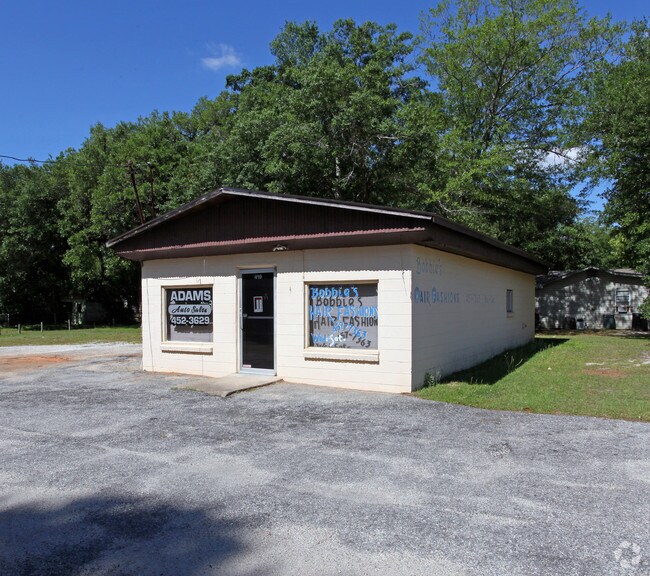
Property Detail
419 Iroquois St
22-09-44-0-014-274
LOTS 31,32,33,34 & 36 BLK 55 NORTH MOBILE SUBD DBK 145 N S PG 252 #SEC 44 T3S R1W #MP22 09 44 0 014
Autorepair
Mobile
B and X Area of moderate flood hazard, usually the area between the limits of the 100-year and 500-year floods.
Alabama
2025
0.28 AC
2025
Prichard/Saraland
005100
Mobile
861 SF
Mobile, AL
NEARBY LISTINGS FOR SALE OR LEASE
DEMOGRAPHICS near 419 Iroquois St
1 mile
3 mile
5 mile
2025 Total Population
7,424
31,396
68,767
2030 Population
7,471
32,128
69,878
Pop Growth 2025-2030
+ 0.63%
+ 2.33%
+ 1.62%
Average Age
38
41
41
2025 Total Households
2,953
12,304
27,353
HH Growth 2025-2030
+ 0.54%
+ 2.45%
+ 1.70%
Median Household Inc
$36,601
$35,943
$37,519
Avg Household Size
2.50
2.40
2.40
2025 Avg HH Vehicles
2.00
2.00
2.00
Median Home Value
$95,848
$80,115
$100,266
Median Year Built
1963
1966
1968
Nearby Places
Map Layers
Map Styles
 Street
 Aerial
Layers
 Traffic
 Biking
Places
Listings with unknown addresses are not visible on the map
- Restaurants
- Banks
- Shops
- Fitness
- Groceries
PUBLIC TRANSPORTATION
AIRPORT
Mobile International
Drive
Walk
Distance
Mobile International
20 min
12.1 mi
Mobile Regional
Drive
Walk
Distance
Mobile Regional
29 min
15.9 mi
Freight Ports
Port of Mobile
Drive
Walk
Distance
Port of Mobile
10 min
6.9 mi
Nearby Properties
Address
Land Use
TOTAL SIZE
Lot Size
Zoning
Address
Land Use
TOTAL SIZE
Lot Size
Zoning
9,100 SF
34.07 AC
Address
Land Use
TOTAL SIZE
Lot Size
Zoning
153,780 SF
Address
Land Use
TOTAL SIZE
Lot Size
Zoning
35,775 SF
22.48 AC
Address
Land Use
TOTAL SIZE
Lot Size
Zoning
200,370 SF
47.96 AC
Address
Land Use
TOTAL SIZE
Lot Size
Zoning
35,828 SF
26.30 AC
Address
Land Use
TOTAL SIZE
Lot Size
Zoning
187,257 SF
33.10 AC
Address
Land Use
TOTAL SIZE
Lot Size
Zoning
5,000 SF
13.33 AC
Address
Land Use
TOTAL SIZE
Lot Size
Zoning
21,700 SF
6.98 AC
Address
Land Use
TOTAL SIZE
Lot Size
Zoning
197,471 SF
15.90 AC
Address
Land Use
TOTAL SIZE
Lot Size
Zoning
5,553 SF
40.77 AC
Address
Land Use
TOTAL SIZE
Lot Size
Zoning
97,443 SF
98.83 AC
Address
Land Use
TOTAL SIZE
Lot Size
Zoning
131,516 SF
15 AC
Address
Land Use
TOTAL SIZE
Lot Size
Zoning
53,850 SF
12 AC
Address
Land Use
TOTAL SIZE
Lot Size
Zoning
54,965 SF
1.97 AC
Address
Land Use
TOTAL SIZE
Lot Size
Zoning
3,188 SF
10.16 AC
Address
Land Use
TOTAL SIZE
Lot Size
Zoning
87,532 SF
17 AC
Address
Land Use
TOTAL SIZE
Lot Size
Zoning
86,174 SF
9.30 AC
Address
Land Use
TOTAL SIZE
Lot Size
Zoning
18,818 SF
6.21 AC
Address
Land Use
TOTAL SIZE
Lot Size
Zoning
66,025 SF
9.70 AC
Address
Land Use
TOTAL SIZE
Lot Size
Zoning
94,787 SF
18 AC
Address
Land Use
TOTAL SIZE
Lot Size
Zoning
40,245 SF
1.99 AC
Address
Land Use
TOTAL SIZE
Lot Size
Zoning
48,304 SF
3.28 AC
Address
Land Use
TOTAL SIZE
Lot Size
Zoning
143,623 SF
11.94 AC
Address
Land Use
TOTAL SIZE
Lot Size
Zoning
101,578 SF
32 AC
Address
Land Use
TOTAL SIZE
Lot Size
Zoning
58,789 SF
17 AC
Address
Land Use
TOTAL SIZE
Lot Size
Zoning
5,384 SF
18 AC
Address
Land Use
TOTAL SIZE
Lot Size
Zoning
107,965 SF
8.14 AC
Address
Land Use
TOTAL SIZE
Lot Size
Zoning
58,624 SF
8.30 AC
Address
Land Use
TOTAL SIZE
Lot Size
Zoning
74,538 SF
4.48 AC
Address
Land Use
TOTAL SIZE
Lot Size
Zoning
122,776 SF
14.32 AC
The World's #1 Commercial Real Estate Marketplace
Connect with us
© 2026 CoStar Group
The information above has been obtained from sources believed reliable. While we do not doubt its accuracy we have not verified it and make no guarantee, warranty or representation about it. It is your responsibility to independently confirm its accuracy and completeness. Any projections, opinions, assumptions, or estimates used are for example only and do not represent the current or future performance of the property. The value of this transaction to you depends on tax and other factors which should be evaluated by your tax, financial, and legal advisors. You and your advisors should conduct a careful, independent investigation of the property to determine to your satisfaction the suitability of the property for your needs.