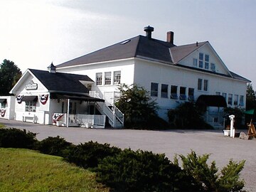
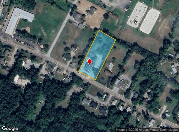
Property Record
419 Main St, Colchester, VT 05446
NEARBY LISTINGS FOR SALE OR LEASE
-
-
View all Colchester listings for sale on LoopNet.com
Property Detail
419 Main St
(048) 26-0290030000000
419 MAIN ST
Departmentstore
Chittenden
X
Vermont
50007C0141D
1.75 AC
2024
Vermont North Area
2024
Other Market Areas
002202
Burlington-South Burlington, VT
5,600 SF
DEMOGRAPHICS near 419 Main St
1 Mile
3 Mile
5 Mile
2024 Total Population
1,857
8,845
47,552
2029 Population
1,879
8,988
48,152
Pop Growth 2024-2029
+ 1.18%
+ 1.62%
+ 1.26%
Average Age
42
41
39
2024 Total Households
811
3,891
20,303
HH Growth 2024-2029
+ 1.36%
+ 1.72%
+ 1.33%
Median Household Inc
$88,311
$85,724
$74,538
Avg Household Size
2.30
2.20
2.20
2024 Avg HH Vehicles
2.00
2.00
2.00
Median Home Value
$295,731
$336,418
$341,838
Median Year Built
1991
1990
1979
Nearby Places
Map Layers
Map Styles
 Street
 Aerial
- Restaurants
- Banks
- Shops
- Fitness
- Groceries
PUBLIC TRANSPORTATION
COMMUTER RAIL
Essex Junction-Burlington Amtrak Station (Vermonter - Amtrak)
DRIVE
WALK
Distance
Essex Junction-Burlington Amtrak Station (Vermonter - Amtrak)
9 min
4.7 mi
Btn (Ethan Allen Express - Amtrak)
DRIVE
WALK
Distance
Btn (Ethan Allen Express - Amtrak)
15 min
7.1 mi
AIRPORT
Patrick Leahy Burlington International
DRIVE
WALK
Distance
Patrick Leahy Burlington International
19 min
7.4 mi
Plattsburgh International
DRIVE
WALK
Distance
Plattsburgh International
58 min
27.5 mi
Freight Ports
Montreal
DRIVE
WALK
Distance
Montreal
118 min
91.2 mi
Nearby Properties
Address
Land Use
TOTAL SIZE
Lot Size
Zoning
Address
Land Use
TOTAL SIZE
Lot Size
Zoning
472,662 SF
23.37 AC
Address
Land Use
TOTAL SIZE
Lot Size
Zoning
124,609 SF
17.51 AC
Address
Land Use
TOTAL SIZE
Lot Size
Zoning
Address
Land Use
TOTAL SIZE
Lot Size
Zoning
55,629 SF
2.15 AC
Address
Land Use
TOTAL SIZE
Lot Size
Zoning
103,500 SF
2.95 AC
Address
Land Use
TOTAL SIZE
Lot Size
Zoning
Address
Land Use
TOTAL SIZE
Lot Size
Zoning
Address
Land Use
TOTAL SIZE
Lot Size
Zoning
59,204 SF
Address
Land Use
TOTAL SIZE
Lot Size
Zoning
Address
Land Use
TOTAL SIZE
Lot Size
Zoning
5.17 AC
Address
Land Use
TOTAL SIZE
Lot Size
Zoning
35,124 SF
2.22 AC
Address
Land Use
TOTAL SIZE
Lot Size
Zoning
2.09 AC
Address
Land Use
TOTAL SIZE
Lot Size
Zoning
Address
Land Use
TOTAL SIZE
Lot Size
Zoning
Address
Land Use
TOTAL SIZE
Lot Size
Zoning
5.40 AC
Address
Land Use
TOTAL SIZE
Lot Size
Zoning
Address
Land Use
TOTAL SIZE
Lot Size
Zoning
20,000 SF
2.14 AC
Address
Land Use
TOTAL SIZE
Lot Size
Zoning
3.79 AC
Address
Land Use
TOTAL SIZE
Lot Size
Zoning
15,068 SF
2.07 AC
Address
Land Use
TOTAL SIZE
Lot Size
Zoning
20,950 SF
6.77 AC
Address
Land Use
TOTAL SIZE
Lot Size
Zoning
2.20 AC
Address
Land Use
TOTAL SIZE
Lot Size
Zoning
15,580 SF
3.09 AC
Address
Land Use
TOTAL SIZE
Lot Size
Zoning
15,050 SF
Address
Land Use
TOTAL SIZE
Lot Size
Zoning
Address
Land Use
TOTAL SIZE
Lot Size
Zoning
9,800 SF
3.04 AC
Address
Land Use
TOTAL SIZE
Lot Size
Zoning
Address
Land Use
TOTAL SIZE
Lot Size
Zoning
Address
Land Use
TOTAL SIZE
Lot Size
Zoning
3,694 SF
1.13 AC
Address
Land Use
TOTAL SIZE
Lot Size
Zoning
6,448 SF
1.53 AC
Address
Land Use
TOTAL SIZE
Lot Size
Zoning
6,448 SF
1.53 AC
The World's #1 Commercial Real Estate Marketplace
Connect with us
© 2025 CoStar Group
The information above has been obtained from sources believed reliable. While we do not doubt its accuracy we have not verified it and make no guarantee, warranty or representation about it. It is your responsibility to independently confirm its accuracy and completeness. Any projections, opinions, assumptions, or estimates used are for example only and do not represent the current or future performance of the property. The value of this transaction to you depends on tax and other factors which should be evaluated by your tax, financial, and legal advisors. You and your advisors should conduct a careful, independent investigation of the property to determine to your satisfaction the suitability of the property for your needs.