Property Record
419 N Buchanan St, Lafayette, LA 70501

NEARBY LISTINGS FOR SALE OR LEASE
-
-
No Photo
-
-
-
-
View all Lafayette listings for sale on LoopNet.com
Property Detail
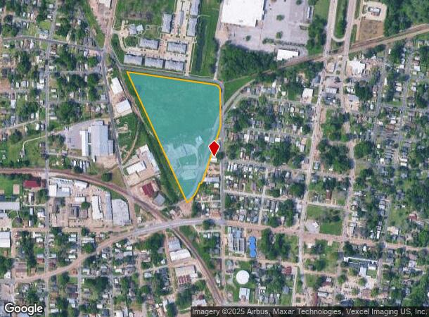
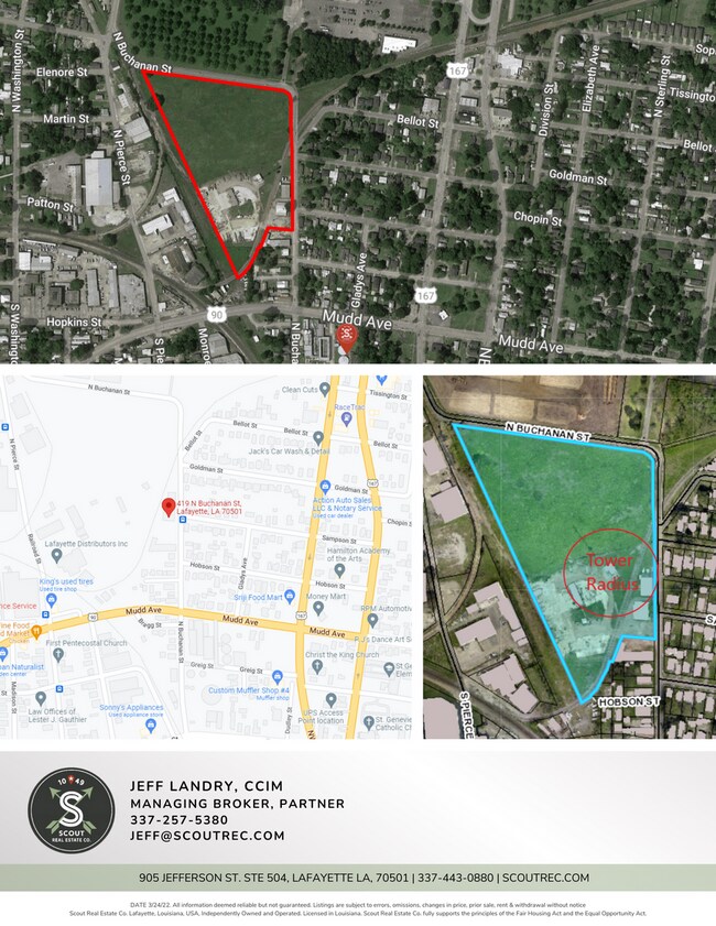
419 N Buchanan St
Lafayette, LA
SEC 26 T9S R4E (13.87 AC) SEC 26 T9S R4E (TRIANGULAR PARCEL)(278970)
6174260
Lafayette
Warehouse
Louisiana
2024
13.87 AC
2024
Greater Lafayette
001100
Lafayette
DEMOGRAPHICS near 419 N Buchanan St
1 mile
3 mile
5 mile
2024 Total Population
12,408
56,790
114,668
2029 Population
13,337
60,416
121,678
Pop Growth 2024-2029
+ 7.49%
+ 6.38%
+ 6.11%
Average Age
39
39
40
2024 Total Households
4,779
24,148
49,349
HH Growth 2024-2029
+ 7.76%
+ 6.36%
+ 6.14%
Median Household Inc
$25,468
$34,263
$46,897
Avg Household Size
2.30
2.20
2.20
2024 Avg HH Vehicles
1.00
1.00
2.00
Median Home Value
$76,983
$150,490
$181,602
Median Year Built
1965
1972
1978
Nearby Places
Map Layers
Map Styles
 Street
 Aerial
Transit
 Traffic
 Biking
Places
Listings with unknown addresses are not visible on the map
- Restaurants
- Banks
- Shops
- Fitness
- Groceries
PUBLIC TRANSPORTATION
COMMUTER RAIL
Drive
Walk
Distance
3 min
13 min
0.7 mi
AIRPORT
Lafayette Regional/Paul Fournet Field
Drive
Walk
Distance
Lafayette Regional/Paul Fournet Field
7 min
3.0 mi
Freight Ports
Port of Iberia
Drive
Walk
Distance
Port of Iberia
33 min
24.3 mi
SALE & LEASE HISTORY
LISTING DATE
SALE/LEASE

Oct 23, 2018
For Sale
May 31, 2022
For Sale
Mar 02, 2018
For Sale
Jun 21, 2023
For Sale
Feb 15, 2018
For Lease
Nearby Properties
Address
Land Use
TOTAL SIZE
Lot Size
Zoning
Address
Land Use
TOTAL SIZE
Lot Size
Zoning
Address
Land Use
TOTAL SIZE
Lot Size
Zoning
Address
Land Use
TOTAL SIZE
Lot Size
Zoning
Address
Land Use
TOTAL SIZE
Lot Size
Zoning
15.14 AC
Address
Land Use
TOTAL SIZE
Lot Size
Zoning
21.64 AC
Address
Land Use
TOTAL SIZE
Lot Size
Zoning
Address
Land Use
TOTAL SIZE
Lot Size
Zoning
921.26 AC
Address
Land Use
TOTAL SIZE
Lot Size
Zoning
4.20 AC
Address
Land Use
TOTAL SIZE
Lot Size
Zoning
28.09 AC
Address
Land Use
TOTAL SIZE
Lot Size
Zoning
273,675 SF
6.38 AC
Address
Land Use
TOTAL SIZE
Lot Size
Zoning
19.73 AC
Address
Land Use
TOTAL SIZE
Lot Size
Zoning
25.22 AC
Address
Land Use
TOTAL SIZE
Lot Size
Zoning
12.34 AC
Address
Land Use
TOTAL SIZE
Lot Size
Zoning
96.54 AC
Address
Land Use
TOTAL SIZE
Lot Size
Zoning
221,760 SF
0.67 AC
Address
Land Use
TOTAL SIZE
Lot Size
Zoning
0.92 AC
Address
Land Use
TOTAL SIZE
Lot Size
Zoning
182,700 SF
25.62 AC
Address
Land Use
TOTAL SIZE
Lot Size
Zoning
10.75 AC
Address
Land Use
TOTAL SIZE
Lot Size
Zoning
132,882 SF
13.98 AC
Address
Land Use
TOTAL SIZE
Lot Size
Zoning
84,009 SF
6.90 AC
Address
Land Use
TOTAL SIZE
Lot Size
Zoning
47,249 SF
22.17 AC
Address
Land Use
TOTAL SIZE
Lot Size
Zoning
84,225 SF
Address
Land Use
TOTAL SIZE
Lot Size
Zoning
7.03 AC
Address
Land Use
TOTAL SIZE
Lot Size
Zoning
1.43 AC
Address
Land Use
TOTAL SIZE
Lot Size
Zoning
123,164 SF
2.11 AC
Address
Land Use
TOTAL SIZE
Lot Size
Zoning
7.77 AC
Address
Land Use
TOTAL SIZE
Lot Size
Zoning
87,868 SF
3.02 AC
Address
Land Use
TOTAL SIZE
Lot Size
Zoning
67,672 SF
10.18 AC
Address
Land Use
TOTAL SIZE
Lot Size
Zoning
120,500 SF
20 AC
Address
Land Use
TOTAL SIZE
Lot Size
Zoning
The World's #1 Commercial Real Estate Marketplace
Connect with us
© 2026 CoStar Group
The information above has been obtained from sources believed reliable. While we do not doubt its accuracy we have not verified it and make no guarantee, warranty or representation about it. It is your responsibility to independently confirm its accuracy and completeness. Any projections, opinions, assumptions, or estimates used are for example only and do not represent the current or future performance of the property. The value of this transaction to you depends on tax and other factors which should be evaluated by your tax, financial, and legal advisors. You and your advisors should conduct a careful, independent investigation of the property to determine to your satisfaction the suitability of the property for your needs.