Property Record
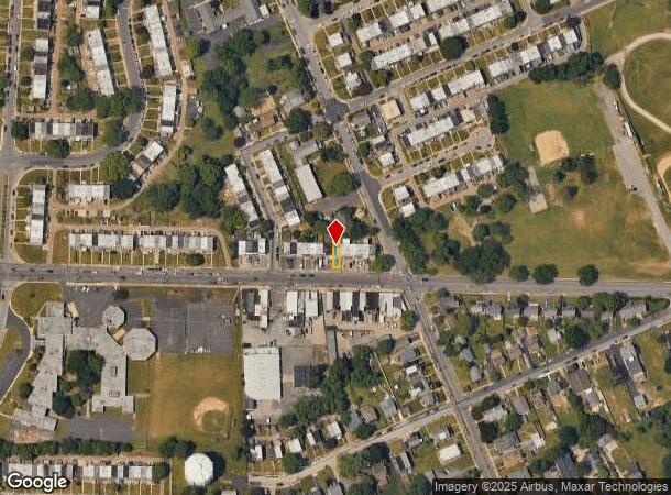
413 N Springfield Rd, Clifton Heights, PA 19018
NEARBY LISTINGS FOR SALE OR LEASE
Property Detail
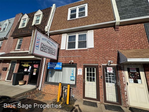
413 N Springfield Rd
10-00-01780-00
2 STY HSE/GARAGE 18 X 100
Restaurantbuilding
Delaware
X
Pennsylvania
42045C0116F
0.41 AC
2024
Delaware County
2025
Philadelphia
403300
Philadelphia-Camden-Wilmington, PA-NJ-DE-MD
1,782 SF
DEMOGRAPHICS near 413 N Springfield Rd
1 Mile
3 Mile
5 Mile
2024 Total Population
25,879
209,278
528,968
2029 Population
25,589
206,687
519,344
Pop Growth 2024-2029
(1.12%)
(1.24%)
(1.82%)
Average Age
39
39
39
2024 Total Households
10,067
79,197
202,966
HH Growth 2024-2029
(1.18%)
(1.28%)
(1.94%)
Median Household Inc
$72,502
$69,604
$62,903
Avg Household Size
2.50
2.60
2.50
2024 Avg HH Vehicles
2.00
2.00
1.00
Median Home Value
$193,450
$208,343
$218,192
Median Year Built
1952
1951
1949
Nearby Places
- Restaurants
- Banks
- Shops
- Fitness
- Groceries
PUBLIC TRANSPORTATION
TRANSIT/SUBWAY
Baltimore Pike (Route 102 - Southeastern Pennsylvania Transportation Authority Rapid Transit (SEPTA Subway & Trolley))
DRIVE
WALK
Distance
Baltimore Pike (Route 102 - Southeastern Pennsylvania Transportation Authority Rapid Transit (SEPTA Subway & Trolley))
2 min
13 min
0.7 mi
Springfield Road (Route 102 - Southeastern Pennsylvania Transportation Authority Rapid Transit (SEPTA Subway & Trolley))
DRIVE
WALK
Distance
Springfield Road (Route 102 - Southeastern Pennsylvania Transportation Authority Rapid Transit (SEPTA Subway & Trolley))
2 min
13 min
0.7 mi
Primos (R3 - Southeastern Pennsylvania Transportation Authority Regional Rail (SEPTA Regional Rail))
DRIVE
WALK
Distance
Primos (R3 - Southeastern Pennsylvania Transportation Authority Regional Rail (SEPTA Regional Rail))
3 min
14 min
0.7 mi
Penn Street (Route 102 - Southeastern Pennsylvania Transportation Authority Rapid Transit (SEPTA Subway & Trolley))
DRIVE
WALK
Distance
Penn Street (Route 102 - Southeastern Pennsylvania Transportation Authority Rapid Transit (SEPTA Subway & Trolley))
3 min
15 min
0.8 mi
COMMUTER RAIL
Philadelphia 30th Street (Atlantic City Line - NJ Transit Commuter Rail (NJ Transit))
DRIVE
WALK
Distance
Philadelphia 30th Street (Atlantic City Line - NJ Transit Commuter Rail (NJ Transit))
27 min
9.3 mi
AIRPORT
Philadelphia International
DRIVE
WALK
Distance
Philadelphia International
21 min
8.6 mi
Freight Ports
South Jersey Port
DRIVE
WALK
Distance
South Jersey Port
1 min
9.2 mi
SALE & LEASE HISTORY
LISTING DATE
SALE/LEASE

Jan 11, 2023
For Lease
Nearby Properties
Address
Land Use
TOTAL SIZE
Lot Size
Zoning
Address
Land Use
TOTAL SIZE
Lot Size
Zoning
158,496 SF
Address
Land Use
TOTAL SIZE
Lot Size
Zoning
15,660 SF
56.60 AC
Address
Land Use
TOTAL SIZE
Lot Size
Zoning
448,864 SF
32.89 AC
Address
Land Use
TOTAL SIZE
Lot Size
Zoning
48,739 SF
30 AC
Address
Land Use
TOTAL SIZE
Lot Size
Zoning
82,153 SF
13.97 AC
Address
Land Use
TOTAL SIZE
Lot Size
Zoning
702,532 SF
11 AC
Address
Land Use
TOTAL SIZE
Lot Size
Zoning
20,880 SF
27.20 AC
Address
Land Use
TOTAL SIZE
Lot Size
Zoning
6,040 SF
16.45 AC
Address
Land Use
TOTAL SIZE
Lot Size
Zoning
25,680 SF
31.64 AC
Address
Land Use
TOTAL SIZE
Lot Size
Zoning
136,972 SF
27 AC
Address
Land Use
TOTAL SIZE
Lot Size
Zoning
312,988 SF
24 AC
Address
Land Use
TOTAL SIZE
Lot Size
Zoning
2,608 SF
198.92 AC
Address
Land Use
TOTAL SIZE
Lot Size
Zoning
12,100 SF
7 AC
Address
Land Use
TOTAL SIZE
Lot Size
Zoning
131,980 SF
9.17 AC
Address
Land Use
TOTAL SIZE
Lot Size
Zoning
261,618 SF
30.57 AC
Address
Land Use
TOTAL SIZE
Lot Size
Zoning
40,572 SF
6.52 AC
Address
Land Use
TOTAL SIZE
Lot Size
Zoning
68,096 SF
7.78 AC
Address
Land Use
TOTAL SIZE
Lot Size
Zoning
282,520 SF
24.44 AC
Address
Land Use
TOTAL SIZE
Lot Size
Zoning
86,052 SF
7.63 AC
Address
Land Use
TOTAL SIZE
Lot Size
Zoning
Address
Land Use
TOTAL SIZE
Lot Size
Zoning
187,056 SF
16 AC
Address
Land Use
TOTAL SIZE
Lot Size
Zoning
164,834 SF
13 AC
Address
Land Use
TOTAL SIZE
Lot Size
Zoning
60,588 SF
9.43 AC
Address
Land Use
TOTAL SIZE
Lot Size
Zoning
33,326 SF
7.73 AC
Address
Land Use
TOTAL SIZE
Lot Size
Zoning
140,426 SF
10.46 AC
Address
Land Use
TOTAL SIZE
Lot Size
Zoning
40,850 SF
25.81 AC
Address
Land Use
TOTAL SIZE
Lot Size
Zoning
122,018 SF
16.24 AC
Address
Land Use
TOTAL SIZE
Lot Size
Zoning
90,368 SF
124 AC
Address
Land Use
TOTAL SIZE
Lot Size
Zoning
150,450 SF
9 AC
Address
Land Use
TOTAL SIZE
Lot Size
Zoning
51,280 SF
7 AC
The World's #1 Commercial Real Estate Marketplace
Connect with us
© 2025 CoStar Group
The information above has been obtained from sources believed reliable. While we do not doubt its accuracy we have not verified it and make no guarantee, warranty or representation about it. It is your responsibility to independently confirm its accuracy and completeness. Any projections, opinions, assumptions, or estimates used are for example only and do not represent the current or future performance of the property. The value of this transaction to you depends on tax and other factors which should be evaluated by your tax, financial, and legal advisors. You and your advisors should conduct a careful, independent investigation of the property to determine to your satisfaction the suitability of the property for your needs.