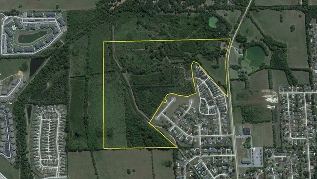
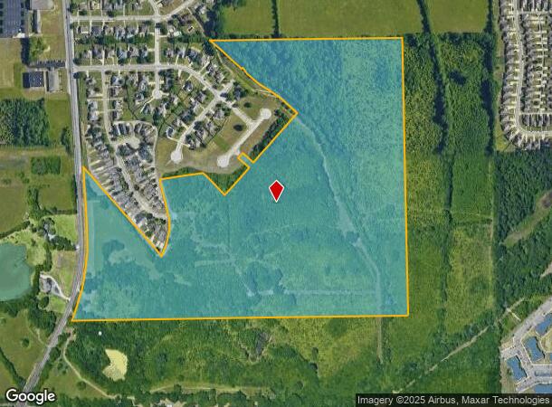
Property Record
Bell Rd, Montgomery, AL 36116
NEARBY LISTINGS FOR SALE OR LEASE
-
-
-
-
Troy Hwy & Christine Elizabeth Curve
Montgomery, AL 36116
$250,000 - $700,000
5.46 - 11.07 AC Lot
Land
-
-
-
-
View all Montgomery listings for sale on LoopNet.com
Property Detail
Bell Rd
09-09-31-1-000-001.000
SEC 31 T16N R19E 76.2 AC IN NE1/4 0909311000001000
Commercialacreage
Montgomery
AE
Alabama
01101C0229H
76.20 AC
2025
North Montgomery
2025
Montgomery
005614
Montgomery, AL
DEMOGRAPHICS near Bell Rd
1 Mile
3 Mile
5 Mile
2024 Total Population
4,400
43,304
102,149
2029 Population
4,158
41,757
98,542
Pop Growth 2024-2029
(5.50%)
(3.57%)
(3.53%)
Average Age
37
37
38
2024 Total Households
1,981
18,724
43,285
HH Growth 2024-2029
(5.81%)
(3.75%)
(3.62%)
Median Household Inc
$71,249
$59,840
$59,385
Avg Household Size
2.20
2.30
2.30
2024 Avg HH Vehicles
2.00
2.00
2.00
Median Home Value
$176,243
$195,196
$177,961
Median Year Built
1996
1993
1987
Nearby Places
Map Layers
Map Styles
 Street
 Aerial
- Restaurants
- Banks
- Shops
- Fitness
- Groceries
PUBLIC TRANSPORTATION
AIRPORT
Montgomery Regional (Dannelly Field)
DRIVE
WALK
Distance
Montgomery Regional (Dannelly Field)
22 min
14.6 mi
Freight Ports
Port of Panama City
DRIVE
WALK
Distance
Port of Panama City
233 min
183.7 mi
SALE & LEASE HISTORY
LISTING DATE
SALE/LEASE

Sep 24, 2016
For Sale
Nearby Properties
Address
Land Use
TOTAL SIZE
Lot Size
Zoning
Address
Land Use
TOTAL SIZE
Lot Size
Zoning
4,998 SF
27.50 AC
R-65-M
Address
Land Use
TOTAL SIZE
Lot Size
Zoning
16,400 SF
28.35 AC
R-65-M
Address
Land Use
TOTAL SIZE
Lot Size
Zoning
1,343 SF
31.75 AC
R-65-M
Address
Land Use
TOTAL SIZE
Lot Size
Zoning
4,597 SF
12.36 AC
PUD
Address
Land Use
TOTAL SIZE
Lot Size
Zoning
4,836 SF
16.25 AC
R-75-M
Address
Land Use
TOTAL SIZE
Lot Size
Zoning
129,776 SF
6.13 AC
PUD
Address
Land Use
TOTAL SIZE
Lot Size
Zoning
15,932 SF
25.50 AC
R-60-M
Address
Land Use
TOTAL SIZE
Lot Size
Zoning
47,292 SF
63.99 AC
Address
Land Use
TOTAL SIZE
Lot Size
Zoning
76,996 SF
15.51 AC
B-3
Address
Land Use
TOTAL SIZE
Lot Size
Zoning
38,646 SF
12.26 AC
PUD
Address
Land Use
TOTAL SIZE
Lot Size
Zoning
23,642 SF
13.70 AC
PUD
Address
Land Use
TOTAL SIZE
Lot Size
Zoning
57,408 SF
24.61 AC
Address
Land Use
TOTAL SIZE
Lot Size
Zoning
1,554 SF
18.26 AC
R-75-M
Address
Land Use
TOTAL SIZE
Lot Size
Zoning
10,317 SF
16.70 AC
AGR-1
Address
Land Use
TOTAL SIZE
Lot Size
Zoning
127,082 SF
7.81 AC
PUD
Address
Land Use
TOTAL SIZE
Lot Size
Zoning
2,885 SF
14 AC
R-75-M
Address
Land Use
TOTAL SIZE
Lot Size
Zoning
201,515 SF
4.46 AC
Address
Land Use
TOTAL SIZE
Lot Size
Zoning
24,360 SF
26.59 AC
R-65-M
Address
Land Use
TOTAL SIZE
Lot Size
Zoning
30.36 AC
PUD
Address
Land Use
TOTAL SIZE
Lot Size
Zoning
30,536 SF
18.06 AC
AGR-1
Address
Land Use
TOTAL SIZE
Lot Size
Zoning
1,964 SF
13.40 AC
R-75-M
Address
Land Use
TOTAL SIZE
Lot Size
Zoning
56,446 SF
18.67 AC
PUD
Address
Land Use
TOTAL SIZE
Lot Size
Zoning
108,176 SF
4.27 AC
B-1-B
Address
Land Use
TOTAL SIZE
Lot Size
Zoning
154,375 SF
21.19 AC
B-3
Address
Land Use
TOTAL SIZE
Lot Size
Zoning
75,510 SF
10.97 AC
B-2
Address
Land Use
TOTAL SIZE
Lot Size
Zoning
125,121 SF
12.28 AC
PUD
Address
Land Use
TOTAL SIZE
Lot Size
Zoning
2,679 SF
10.77 AC
R-75-M
Address
Land Use
TOTAL SIZE
Lot Size
Zoning
208,584 SF
21.10 AC
B-3
Address
Land Use
TOTAL SIZE
Lot Size
Zoning
21,634 SF
6.64 AC
Address
Land Use
TOTAL SIZE
Lot Size
Zoning
31,521 SF
6.98 AC
PUD
The World's #1 Commercial Real Estate Marketplace
Connect with us
© 2026 CoStar Group
The information above has been obtained from sources believed reliable. While we do not doubt its accuracy we have not verified it and make no guarantee, warranty or representation about it. It is your responsibility to independently confirm its accuracy and completeness. Any projections, opinions, assumptions, or estimates used are for example only and do not represent the current or future performance of the property. The value of this transaction to you depends on tax and other factors which should be evaluated by your tax, financial, and legal advisors. You and your advisors should conduct a careful, independent investigation of the property to determine to your satisfaction the suitability of the property for your needs.