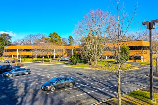
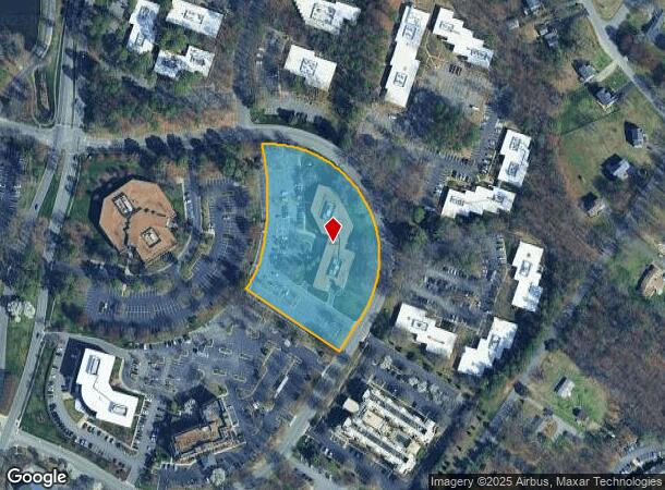
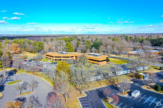
Property Record
4191 Innslake Dr, Glen Allen, VA 23060
Current Lease Availabilities
NEARBY LISTINGS FOR SALE OR LEASE
Property Detail
4191 Innslake Dr
749-761-5569
Innsbrook
Officebuilding
0048050000A 0016; INNSBROOK SC AFI BL A AC 3.89 78 A2 9
X
Henrico
51085C0290C
Virginia
2025
3.89 AC
2025
Innsbrook
200151
Richmond VA
41,838 SF
Richmond, VA
DEMOGRAPHICS near 4191 Innslake Dr
1 Mile
3 Mile
5 Mile
2024 Total Population
7,867
89,321
188,661
2029 Population
7,820
88,895
188,364
Pop Growth 2024-2029
(0.60%)
(0.48%)
(0.16%)
Average Age
37
39
40
2024 Total Households
3,330
34,915
74,356
HH Growth 2024-2029
(0.60%)
(0.51%)
(0.17%)
Median Household Inc
$88,438
$102,309
$96,086
Avg Household Size
2.30
2.50
2.50
2024 Avg HH Vehicles
2.00
2.00
2.00
Median Home Value
$381,434
$388,703
$385,792
Median Year Built
1992
1991
1987
Nearby Places
Map Layers
Map Styles
 Street
 Aerial
- Restaurants
- Banks
- Shops
- Fitness
- Groceries
PUBLIC TRANSPORTATION
COMMUTER RAIL
DRIVE
WALK
Distance
13 min
6.3 mi
AIRPORT
Richmond International
DRIVE
WALK
Distance
Richmond International
34 min
22.4 mi
Nearby Properties
Address
Land Use
TOTAL SIZE
Lot Size
Zoning
Address
Land Use
TOTAL SIZE
Lot Size
Zoning
10,290 SF
56.53 AC
B-3C
Address
Land Use
TOTAL SIZE
Lot Size
Zoning
632,549 SF
90.12 AC
R-6
Address
Land Use
TOTAL SIZE
Lot Size
Zoning
37.36 AC
R-5C
Address
Land Use
TOTAL SIZE
Lot Size
Zoning
585,792 SF
38.94 AC
R-5
Address
Land Use
TOTAL SIZE
Lot Size
Zoning
57,104 SF
0.02 AC
UMUC
Address
Land Use
TOTAL SIZE
Lot Size
Zoning
403,784 SF
40.74 AC
MIXE
Address
Land Use
TOTAL SIZE
Lot Size
Zoning
527,410 SF
40.70 AC
A-1
Address
Land Use
TOTAL SIZE
Lot Size
Zoning
417,042 SF
49.96 AC
O-3C
Address
Land Use
TOTAL SIZE
Lot Size
Zoning
254,325 SF
60.28 AC
A-1
Address
Land Use
TOTAL SIZE
Lot Size
Zoning
340 SF
23.32 AC
MIXE
Address
Land Use
TOTAL SIZE
Lot Size
Zoning
252,912 SF
28.54 AC
R-6
Address
Land Use
TOTAL SIZE
Lot Size
Zoning
266,138 SF
96.10 AC
R-2C
Address
Land Use
TOTAL SIZE
Lot Size
Zoning
184,760 SF
51.60 AC
A-1
Address
Land Use
TOTAL SIZE
Lot Size
Zoning
278,084 SF
21.70 AC
R-6C
Address
Land Use
TOTAL SIZE
Lot Size
Zoning
309,500 SF
29.78 AC
MIXE
Address
Land Use
TOTAL SIZE
Lot Size
Zoning
271,060 SF
18.31 AC
R-6
Address
Land Use
TOTAL SIZE
Lot Size
Zoning
311,196 SF
27.62 AC
R-5
Address
Land Use
TOTAL SIZE
Lot Size
Zoning
306,040 SF
32.24 AC
R-5
Address
Land Use
TOTAL SIZE
Lot Size
Zoning
282,400 SF
18.71 AC
MIXE
Address
Land Use
TOTAL SIZE
Lot Size
Zoning
289,752 SF
24.72 AC
R-5C
Address
Land Use
TOTAL SIZE
Lot Size
Zoning
250,146 SF
20.41 AC
R-5
Address
Land Use
TOTAL SIZE
Lot Size
Zoning
296,784 SF
23.11 AC
R-5
Address
Land Use
TOTAL SIZE
Lot Size
Zoning
159,980 SF
21.38 AC
R-5C
Address
Land Use
TOTAL SIZE
Lot Size
Zoning
5.43 AC
UMUC
Address
Land Use
TOTAL SIZE
Lot Size
Zoning
7.98 AC
UMUC
Address
Land Use
TOTAL SIZE
Lot Size
Zoning
17,850 SF
33 AC
A-1
Address
Land Use
TOTAL SIZE
Lot Size
Zoning
500,400 SF
31.15 AC
R-5
Address
Land Use
TOTAL SIZE
Lot Size
Zoning
138,713 SF
46.53 AC
A-1
Address
Land Use
TOTAL SIZE
Lot Size
Zoning
232,368 SF
26.11 AC
R-5
Address
Land Use
TOTAL SIZE
Lot Size
Zoning
243,357 SF
32.34 AC
MIXE
The World's #1 Commercial Real Estate Marketplace
Connect with us
© 2026 CoStar Group
The information above has been obtained from sources believed reliable. While we do not doubt its accuracy we have not verified it and make no guarantee, warranty or representation about it. It is your responsibility to independently confirm its accuracy and completeness. Any projections, opinions, assumptions, or estimates used are for example only and do not represent the current or future performance of the property. The value of this transaction to you depends on tax and other factors which should be evaluated by your tax, financial, and legal advisors. You and your advisors should conduct a careful, independent investigation of the property to determine to your satisfaction the suitability of the property for your needs.