Property Record
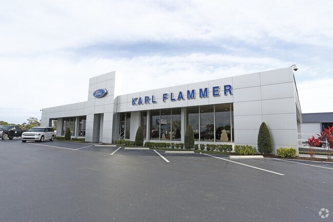
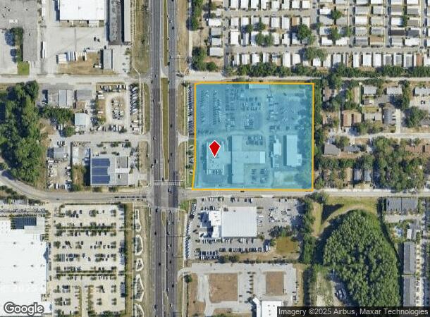
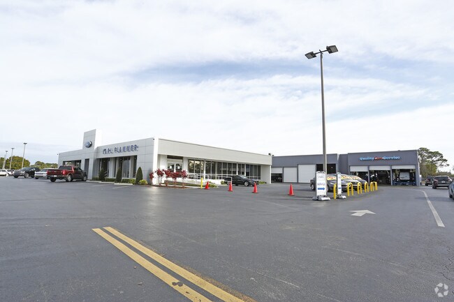
41975 Us Highway 19 N, Tarpon Springs, FL 34689
NEARBY LISTINGS FOR SALE OR LEASE
Property Detail
41975 Us Highway 19 N
07-27-16-00000-130-0100
Pt Of Sw 1/4 Of Ne 1/4
Vehiclerentalsvehiclesales
PT OF SW 1/4 OF NE 1/4 DESC AS BEG AT INTER OF W R/W OF JAPONICA AVE AND S R/W OF LIVE OAK ST TH S ALG W R/W OF JAPONICA AVE 519.5FT TH W ALG N R/W OF SPRUCE ST 557.24FT TH NELY ALG CURVE TO LEFT RAD 2316.83FT ARC DIST 131.48FT TH N ALG E R/W OF US H
X
Pinellas
12103C0038H
Florida
2024
6.93 AC
2025
North Pinellas
027401
Tampa/St Petersburg
42,803 SF
Tampa-St. Petersburg-Clearwater, FL
DEMOGRAPHICS near 41975 Us Highway 19 N
1 Mile
3 Mile
5 Mile
2024 Total Population
6,498
63,176
144,017
2029 Population
6,568
69,458
159,276
Pop Growth 2024-2029
+ 1.08%
+ 9.94%
+ 10.60%
Average Age
47
46
45
2024 Total Households
2,998
27,679
61,519
HH Growth 2024-2029
+ 0.90%
+ 10.04%
+ 10.42%
Median Household Inc
$50,614
$49,828
$55,396
Avg Household Size
2.10
2.20
2.30
2024 Avg HH Vehicles
1.00
2.00
2.00
Median Home Value
$263,813
$226,684
$257,023
Median Year Built
1983
1979
1982
Nearby Places
Map Layers
Map Styles
 Street
 Aerial
- Restaurants
- Banks
- Shops
- Fitness
- Groceries
PUBLIC TRANSPORTATION
AIRPORT
Tampa International
DRIVE
WALK
Distance
Tampa International
40 min
23.0 mi
St Pete-Clearwater International
DRIVE
WALK
Distance
St Pete-Clearwater International
39 min
23.1 mi
Freight Ports
Port of Tampa Bay
DRIVE
WALK
Distance
Port of Tampa Bay
53 min
31.4 mi
Nearby Properties
Address
Land Use
TOTAL SIZE
Lot Size
Zoning
Address
Land Use
TOTAL SIZE
Lot Size
Zoning
341,775 SF
43.99 AC
Address
Land Use
TOTAL SIZE
Lot Size
Zoning
322,856 SF
70.93 AC
RPD5
Address
Land Use
TOTAL SIZE
Lot Size
Zoning
214,040 SF
8.47 AC
Address
Land Use
TOTAL SIZE
Lot Size
Zoning
286,598 SF
6.56 AC
Address
Land Use
TOTAL SIZE
Lot Size
Zoning
171,009 SF
49.16 AC
RPD10
Address
Land Use
TOTAL SIZE
Lot Size
Zoning
202,954 SF
49.22 AC
AR
Address
Land Use
TOTAL SIZE
Lot Size
Zoning
208,427 SF
12.11 AC
Address
Land Use
TOTAL SIZE
Lot Size
Zoning
333,044 SF
25.64 AC
R4
Address
Land Use
TOTAL SIZE
Lot Size
Zoning
144,838 SF
15.52 AC
CP1
Address
Land Use
TOTAL SIZE
Lot Size
Zoning
154,033 SF
15.86 AC
Address
Land Use
TOTAL SIZE
Lot Size
Zoning
157,476 SF
27.47 AC
MPUD
Address
Land Use
TOTAL SIZE
Lot Size
Zoning
137,649 SF
8.08 AC
Address
Land Use
TOTAL SIZE
Lot Size
Zoning
273,134 SF
1.44 AC
RPD5
Address
Land Use
TOTAL SIZE
Lot Size
Zoning
151,825 SF
18.01 AC
Address
Land Use
TOTAL SIZE
Lot Size
Zoning
4,955 SF
135.03 AC
Address
Land Use
TOTAL SIZE
Lot Size
Zoning
91,644 SF
29.39 AC
RPD25
Address
Land Use
TOTAL SIZE
Lot Size
Zoning
131,819 SF
11.24 AC
Address
Land Use
TOTAL SIZE
Lot Size
Zoning
81,053 SF
9.52 AC
Address
Land Use
TOTAL SIZE
Lot Size
Zoning
121,869 SF
4.72 AC
C2
Address
Land Use
TOTAL SIZE
Lot Size
Zoning
141,763 SF
12.96 AC
Address
Land Use
TOTAL SIZE
Lot Size
Zoning
67,179 SF
9.52 AC
Address
Land Use
TOTAL SIZE
Lot Size
Zoning
80,212 SF
6.64 AC
Address
Land Use
TOTAL SIZE
Lot Size
Zoning
86,556 SF
7.44 AC
R6
Address
Land Use
TOTAL SIZE
Lot Size
Zoning
77,716 SF
2.54 AC
Address
Land Use
TOTAL SIZE
Lot Size
Zoning
203,135 SF
41.04 AC
C2
Address
Land Use
TOTAL SIZE
Lot Size
Zoning
143,430 SF
8.68 AC
Address
Land Use
TOTAL SIZE
Lot Size
Zoning
87,794 SF
7.97 AC
Address
Land Use
TOTAL SIZE
Lot Size
Zoning
70,901 SF
5.70 AC
Address
Land Use
TOTAL SIZE
Lot Size
Zoning
66.18 AC
RPD5
Address
Land Use
TOTAL SIZE
Lot Size
Zoning
45,674 SF
4.21 AC
The World's #1 Commercial Real Estate Marketplace
Connect with us
© 2025 CoStar Group
The information above has been obtained from sources believed reliable. While we do not doubt its accuracy we have not verified it and make no guarantee, warranty or representation about it. It is your responsibility to independently confirm its accuracy and completeness. Any projections, opinions, assumptions, or estimates used are for example only and do not represent the current or future performance of the property. The value of this transaction to you depends on tax and other factors which should be evaluated by your tax, financial, and legal advisors. You and your advisors should conduct a careful, independent investigation of the property to determine to your satisfaction the suitability of the property for your needs.