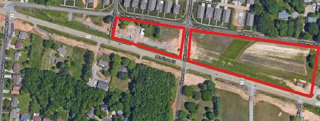
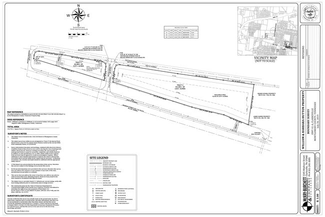
Property Record
S Highway 41A, Adams, TN 37010

NEARBY LISTINGS FOR SALE OR LEASE
Property Detail
S Highway 41A
081-025.00
7-79 AFFIDAVIT DEED IN V810-1612 T-02; PCL SZ RED W/R.O.W DEED V1270-1175 & AC PLANIMETERED & HSE & BLDG TAKEN BY STATE-IMP
Agriculturalland
Montgomery
X
Tennessee
47147C0175C
2.92 AC
2024
Montgomery County
2024
Nashville
101808
Clarksville, TN-KY
DEMOGRAPHICS near S Highway 41A
1 Mile
3 Mile
5 Mile
2024 Total Population
5,745
27,400
51,918
2029 Population
6,758
32,408
61,244
Pop Growth 2024-2029
+ 17.63%
+ 18.28%
+ 17.96%
Average Age
40
39
38
2024 Total Households
2,224
10,210
19,851
HH Growth 2024-2029
+ 18.12%
+ 18.75%
+ 18.44%
Median Household Inc
$96,445
$87,761
$80,040
Avg Household Size
2.60
2.70
2.60
2024 Avg HH Vehicles
2.00
2.00
2.00
Median Home Value
$332,432
$287,644
$293,154
Median Year Built
2004
2000
1997
Nearby Places
- Restaurants
- Banks
- Shops
- Fitness
- Groceries
SALE & LEASE HISTORY
LISTING DATE
SALE/LEASE

Mar 13, 2020
For Sale
Apr 24, 2017
For Sale
Nearby Properties
Address
Land Use
TOTAL SIZE
Lot Size
Zoning
Address
Land Use
TOTAL SIZE
Lot Size
Zoning
30,156 SF
48.80 AC
R-1A
Address
Land Use
TOTAL SIZE
Lot Size
Zoning
195,643 SF
9.92 AC
M-3
Address
Land Use
TOTAL SIZE
Lot Size
Zoning
142,230 SF
20.75 AC
R-1
Address
Land Use
TOTAL SIZE
Lot Size
Zoning
93,218 SF
19.99 AC
R-1
Address
Land Use
TOTAL SIZE
Lot Size
Zoning
72,152 SF
35.48 AC
AG
Address
Land Use
TOTAL SIZE
Lot Size
Zoning
33,940 SF
6.17 AC
R-2
Address
Land Use
TOTAL SIZE
Lot Size
Zoning
25,440 SF
6.40 AC
C-3
Address
Land Use
TOTAL SIZE
Lot Size
Zoning
52,249 SF
11.77 AC
R-1
Address
Land Use
TOTAL SIZE
Lot Size
Zoning
57,113 SF
9.61 AC
R-1
Address
Land Use
TOTAL SIZE
Lot Size
Zoning
207,010 SF
24.57 AC
C-5
Address
Land Use
TOTAL SIZE
Lot Size
Zoning
20,088 SF
4.64 AC
R-1
Address
Land Use
TOTAL SIZE
Lot Size
Zoning
95,725 SF
17.26 AC
M-3
Address
Land Use
TOTAL SIZE
Lot Size
Zoning
53,430 SF
9.21 AC
O-1
Address
Land Use
TOTAL SIZE
Lot Size
Zoning
43,896 SF
16.43 AC
R-4
Address
Land Use
TOTAL SIZE
Lot Size
Zoning
28,113 SF
7.99 AC
R-1
Address
Land Use
TOTAL SIZE
Lot Size
Zoning
18,804 SF
4.77 AC
AG
Address
Land Use
TOTAL SIZE
Lot Size
Zoning
31,416 SF
3.32 AC
R-2
Address
Land Use
TOTAL SIZE
Lot Size
Zoning
28,096 SF
10.16 AC
AG
Address
Land Use
TOTAL SIZE
Lot Size
Zoning
49.94 AC
R-1
Address
Land Use
TOTAL SIZE
Lot Size
Zoning
3,928 SF
20.69 AC
R-1
Address
Land Use
TOTAL SIZE
Lot Size
Zoning
18,744 SF
5.85 AC
C-4
Address
Land Use
TOTAL SIZE
Lot Size
Zoning
22,620 SF
5.13 AC
R-1
Address
Land Use
TOTAL SIZE
Lot Size
Zoning
20,896 SF
12.49 AC
R-4
Address
Land Use
TOTAL SIZE
Lot Size
Zoning
29,414 SF
6.81 AC
C5
Address
Land Use
TOTAL SIZE
Lot Size
Zoning
55,080 SF
5.41 AC
C5
Address
Land Use
TOTAL SIZE
Lot Size
Zoning
7,840 SF
94.94 AC
R-1
Address
Land Use
TOTAL SIZE
Lot Size
Zoning
10,000 SF
11.03 AC
C-3
Address
Land Use
TOTAL SIZE
Lot Size
Zoning
10,933 SF
5.01 AC
R-1
Address
Land Use
TOTAL SIZE
Lot Size
Zoning
47,466 SF
7.59 AC
C-4
Address
Land Use
TOTAL SIZE
Lot Size
Zoning
36,751 SF
10.34 AC
C-3
The World's #1 Commercial Real Estate Marketplace
Connect with us
© 2025 CoStar Group
The information above has been obtained from sources believed reliable. While we do not doubt its accuracy we have not verified it and make no guarantee, warranty or representation about it. It is your responsibility to independently confirm its accuracy and completeness. Any projections, opinions, assumptions, or estimates used are for example only and do not represent the current or future performance of the property. The value of this transaction to you depends on tax and other factors which should be evaluated by your tax, financial, and legal advisors. You and your advisors should conduct a careful, independent investigation of the property to determine to your satisfaction the suitability of the property for your needs.