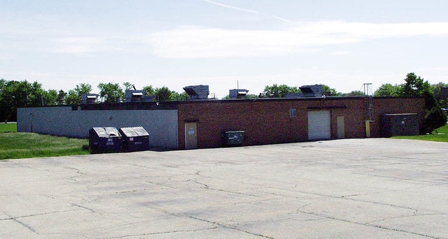
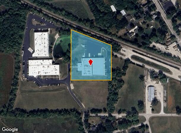
Property Record
41W195 Railroad St, Pingree Grove, IL 60140
Current Lease Availabilities
NEARBY LISTINGS FOR SALE OR LEASE
Property Detail
41W195 Railroad St
Chicago-Naperville-Elgin, IL-IN-WI
Pingree Grove Ind Park
02-33-451-005
THAT PART OF THE SOUTH 1/2 OF THE S/E 1/4 OF SECTION 33, TOWNSHIP 42 NORTH, RANGE 7 EAST OF THE THIRD PRINCIPAL MERIDIAN.
Industrialgeneral
Kane
X
Illinois
17089C0135H
5
2024
3.96 AC
2024
North Kane/I-90
850705
Chicago
20,040 SF
DEMOGRAPHICS near 41W195 Railroad St
1 Mile
3 Mile
5 Mile
2024 Total Population
1,926
20,241
50,278
2029 Population
1,908
20,146
49,678
Pop Growth 2024-2029
(0.93%)
(0.47%)
(1.19%)
Average Age
36
37
40
2024 Total Households
626
6,619
17,270
HH Growth 2024-2029
(1.12%)
(0.65%)
(1.30%)
Median Household Inc
$111,342
$115,688
$119,029
Avg Household Size
3.00
3.00
2.90
2024 Avg HH Vehicles
2.00
2.00
2.00
Median Home Value
$290,421
$317,323
$322,960
Median Year Built
2006
2005
2001
Nearby Places
Map Layers
Map Styles
 Street
 Aerial
- Restaurants
- Banks
- Shops
- Fitness
- Groceries
PUBLIC TRANSPORTATION
COMMUTER RAIL
Big Timber Road Station (Milwaukee District West Line - Northeast Illinois Regional Commuter Railroad (Metra))
DRIVE
WALK
Distance
Big Timber Road Station (Milwaukee District West Line - Northeast Illinois Regional Commuter Railroad (Metra))
15 min
6.6 mi
Elgin Station (Milwaukee District West Line - Northeast Illinois Regional Commuter Railroad (Metra))
DRIVE
WALK
Distance
Elgin Station (Milwaukee District West Line - Northeast Illinois Regional Commuter Railroad (Metra))
15 min
7.8 mi
AIRPORT
Chicago O'Hare International
DRIVE
WALK
Distance
Chicago O'Hare International
66 min
32.4 mi
Chicago Midway International
DRIVE
WALK
Distance
Chicago Midway International
76 min
45.3 mi
Chicago/Rockford International
DRIVE
WALK
Distance
Chicago/Rockford International
63 min
46.1 mi
Nearby Properties
Address
Land Use
TOTAL SIZE
Lot Size
Zoning
Address
Land Use
TOTAL SIZE
Lot Size
Zoning
Address
Land Use
TOTAL SIZE
Lot Size
Zoning
101,250 SF
17.98 AC
Address
Land Use
TOTAL SIZE
Lot Size
Zoning
Address
Land Use
TOTAL SIZE
Lot Size
Zoning
Address
Land Use
TOTAL SIZE
Lot Size
Zoning
3,250 SF
6.46 AC
Address
Land Use
TOTAL SIZE
Lot Size
Zoning
Address
Land Use
TOTAL SIZE
Lot Size
Zoning
Address
Land Use
TOTAL SIZE
Lot Size
Zoning
23,190 SF
1.80 AC
Address
Land Use
TOTAL SIZE
Lot Size
Zoning
2,127 SF
5.79 AC
Address
Land Use
TOTAL SIZE
Lot Size
Zoning
22,000 SF
1.22 AC
Address
Land Use
TOTAL SIZE
Lot Size
Zoning
16.90 AC
Address
Land Use
TOTAL SIZE
Lot Size
Zoning
1.22 AC
Address
Land Use
TOTAL SIZE
Lot Size
Zoning
9,600 SF
2.53 AC
Address
Land Use
TOTAL SIZE
Lot Size
Zoning
1.51 AC
Address
Land Use
TOTAL SIZE
Lot Size
Zoning
14,145 SF
1.11 AC
Address
Land Use
TOTAL SIZE
Lot Size
Zoning
18,000 SF
4.62 AC
Address
Land Use
TOTAL SIZE
Lot Size
Zoning
2.01 AC
Address
Land Use
TOTAL SIZE
Lot Size
Zoning
12,740 SF
2.35 AC
Address
Land Use
TOTAL SIZE
Lot Size
Zoning
2,856 SF
2.14 AC
Address
Land Use
TOTAL SIZE
Lot Size
Zoning
26,420 SF
4.45 AC
Address
Land Use
TOTAL SIZE
Lot Size
Zoning
220 SF
4.36 AC
Address
Land Use
TOTAL SIZE
Lot Size
Zoning
10,200 SF
3.10 AC
Address
Land Use
TOTAL SIZE
Lot Size
Zoning
11,360 SF
1.02 AC
Address
Land Use
TOTAL SIZE
Lot Size
Zoning
11,685 SF
2.95 AC
Address
Land Use
TOTAL SIZE
Lot Size
Zoning
25,695 SF
4.55 AC
Address
Land Use
TOTAL SIZE
Lot Size
Zoning
8,088 SF
1.09 AC
Address
Land Use
TOTAL SIZE
Lot Size
Zoning
0.27 AC
Address
Land Use
TOTAL SIZE
Lot Size
Zoning
7,459 SF
1.85 AC
The World's #1 Commercial Real Estate Marketplace
Connect with us
© 2025 CoStar Group
The information above has been obtained from sources believed reliable. While we do not doubt its accuracy we have not verified it and make no guarantee, warranty or representation about it. It is your responsibility to independently confirm its accuracy and completeness. Any projections, opinions, assumptions, or estimates used are for example only and do not represent the current or future performance of the property. The value of this transaction to you depends on tax and other factors which should be evaluated by your tax, financial, and legal advisors. You and your advisors should conduct a careful, independent investigation of the property to determine to your satisfaction the suitability of the property for your needs.