Property Record
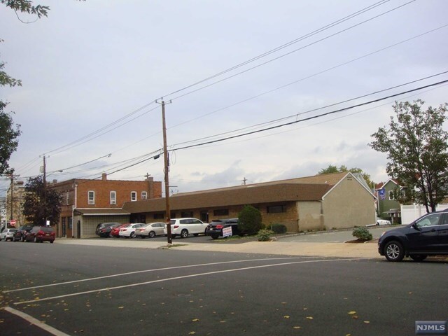
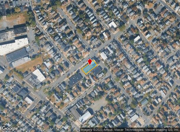
174 Maple Ave, Wallington, NJ 07057
NEARBY LISTINGS FOR SALE OR LEASE
Property Detail
174 Maple Ave
New York-Jersey City-White Plains, NY-NJ
.222 AC
65-00033-0000-00001
Bergen
Commercialnec
New Jersey
X
1
34031C0276G
0.22 AC
2024
Meadowlands
2025
Northern New Jersey
057102
DEMOGRAPHICS near 174 Maple Ave
1 Mile
3 Mile
5 Mile
2024 Total Population
44,564
268,205
598,235
2029 Population
43,500
260,561
582,705
Pop Growth 2024-2029
(2.39%)
(2.85%)
(2.60%)
Average Age
37
39
40
2024 Total Households
15,302
94,195
214,197
HH Growth 2024-2029
(2.58%)
(2.92%)
(2.65%)
Median Household Inc
$57,482
$75,067
$80,589
Avg Household Size
2.80
2.80
2.70
2024 Avg HH Vehicles
1.00
2.00
2.00
Median Home Value
$445,377
$440,243
$426,923
Median Year Built
1952
1951
1954
Nearby Places
Map Layers
Map Styles
 Street
 Aerial
- Restaurants
- Banks
- Shops
- Fitness
- Groceries
PUBLIC TRANSPORTATION
COMMUTER RAIL
Passaic (Main/Port Jervis Line - NJ Transit Commuter Rail (NJ Transit))
DRIVE
WALK
Distance
Passaic (Main/Port Jervis Line - NJ Transit Commuter Rail (NJ Transit))
6 min
17 min
0.9 mi
Garfield (Bergen County/Port Jervis Line - NJ Transit Commuter Rail (NJ Transit))
DRIVE
WALK
Distance
Garfield (Bergen County/Port Jervis Line - NJ Transit Commuter Rail (NJ Transit))
6 min
1.5 mi
AIRPORT
Newark Liberty International
DRIVE
WALK
Distance
Newark Liberty International
20 min
16.2 mi
LaGuardia
DRIVE
WALK
Distance
LaGuardia
35 min
26.9 mi
John F Kennedy International
DRIVE
WALK
Distance
John F Kennedy International
47 min
30.9 mi
Freight Ports
Port Newark Container Terminal
DRIVE
WALK
Distance
Port Newark Container Terminal
1 min
11.4 mi
SALE & LEASE HISTORY
LISTING DATE
SALE/LEASE

Sep 17, 2019
For Lease
Oct 19, 2018
For Lease
Nearby Properties
Address
Land Use
TOTAL SIZE
Lot Size
Zoning
Address
Land Use
TOTAL SIZE
Lot Size
Zoning
Address
Land Use
TOTAL SIZE
Lot Size
Zoning
4,014 SF
21 AC
Address
Land Use
TOTAL SIZE
Lot Size
Zoning
612 AC
SEA
Address
Land Use
TOTAL SIZE
Lot Size
Zoning
335.71 AC
AF
Address
Land Use
TOTAL SIZE
Lot Size
Zoning
Address
Land Use
TOTAL SIZE
Lot Size
Zoning
9.57 AC
I2
Address
Land Use
TOTAL SIZE
Lot Size
Zoning
7.10 AC
R-3
Address
Land Use
TOTAL SIZE
Lot Size
Zoning
Address
Land Use
TOTAL SIZE
Lot Size
Zoning
30.46 AC
I
Address
Land Use
TOTAL SIZE
Lot Size
Zoning
8.88 AC
ORD
Address
Land Use
TOTAL SIZE
Lot Size
Zoning
1,218 SF
41.30 AC
RB
Address
Land Use
TOTAL SIZE
Lot Size
Zoning
1.12 AC
M-O
Address
Land Use
TOTAL SIZE
Lot Size
Zoning
4.80 AC
Address
Land Use
TOTAL SIZE
Lot Size
Zoning
Address
Land Use
TOTAL SIZE
Lot Size
Zoning
18.30 AC
Address
Land Use
TOTAL SIZE
Lot Size
Zoning
144,024 SF
1 AC
LM
Address
Land Use
TOTAL SIZE
Lot Size
Zoning
25.50 AC
B2
Address
Land Use
TOTAL SIZE
Lot Size
Zoning
24.29 AC
Address
Land Use
TOTAL SIZE
Lot Size
Zoning
82.74 AC
Address
Land Use
TOTAL SIZE
Lot Size
Zoning
71,634 SF
12.31 AC
M1
Address
Land Use
TOTAL SIZE
Lot Size
Zoning
16.94 AC
R2
Address
Land Use
TOTAL SIZE
Lot Size
Zoning
24.35 AC
Address
Land Use
TOTAL SIZE
Lot Size
Zoning
13.80 AC
Address
Land Use
TOTAL SIZE
Lot Size
Zoning
11.30 AC
Address
Land Use
TOTAL SIZE
Lot Size
Zoning
150,018 SF
4.17 AC
B
Address
Land Use
TOTAL SIZE
Lot Size
Zoning
Address
Land Use
TOTAL SIZE
Lot Size
Zoning
13.36 AC
Address
Land Use
TOTAL SIZE
Lot Size
Zoning
136,148 SF
12.81 AC
Address
Land Use
TOTAL SIZE
Lot Size
Zoning
167,920 SF
7.51 AC
IA
Address
Land Use
TOTAL SIZE
Lot Size
Zoning
7.22 AC
M-3
The World's #1 Commercial Real Estate Marketplace
Connect with us
© 2025 CoStar Group
The information above has been obtained from sources believed reliable. While we do not doubt its accuracy we have not verified it and make no guarantee, warranty or representation about it. It is your responsibility to independently confirm its accuracy and completeness. Any projections, opinions, assumptions, or estimates used are for example only and do not represent the current or future performance of the property. The value of this transaction to you depends on tax and other factors which should be evaluated by your tax, financial, and legal advisors. You and your advisors should conduct a careful, independent investigation of the property to determine to your satisfaction the suitability of the property for your needs.