Property Record
42 Bartley Rd, Chester, NJ 07930
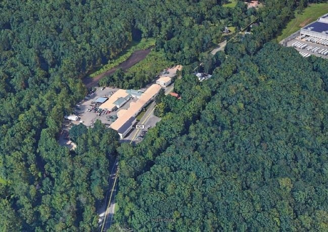

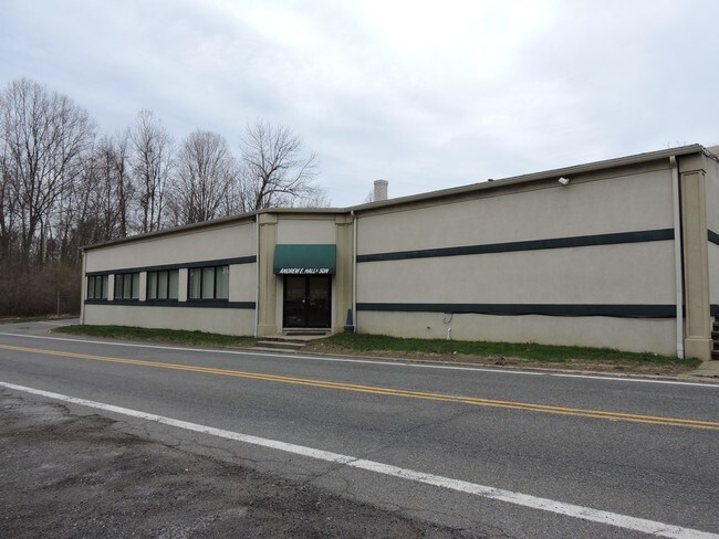
Property Detail
42 Bartley Rd
Newark, NJ
ADDITIONAL LOTS: B6 L35
27-06900-0000-00035
Morris
Warehouse
New Jersey
CR-3
35
2024
11.26 AC
2025
Route 80 Corridor
046298
Northern New Jersey
31,771 SF
NEARBY LISTINGS FOR SALE OR LEASE
DEMOGRAPHICS near 42 Bartley Rd
1 mile
3 mile
5 mile
2025 Total Population
1,106
17,183
57,252
2030 Population
1,135
17,473
58,346
Pop Growth 2025-2030
+ 2.62%
+ 1.69%
+ 1.91%
Average Age
42
42
42
2025 Total Households
389
6,265
20,671
HH Growth 2025-2030
+ 2.83%
+ 1.52%
+ 1.78%
Median Household Inc
$155,519
$151,675
$155,817
Avg Household Size
2.80
2.70
2.70
2025 Avg HH Vehicles
2.00
2.00
2.00
Median Home Value
$487,863
$556,421
$568,029
Median Year Built
1971
1975
1976
Nearby Places
Map Layers
Map Styles
 Street
 Aerial
Layers
 Traffic
 Biking
Places
Listings with unknown addresses are not visible on the map
- Restaurants
- Banks
- Shops
- Fitness
- Groceries
PUBLIC TRANSPORTATION
COMMUTER RAIL
Netcong (Montclair-Boonton Line - NJ Transit Commuter Rail (NJ Transit), Morris & Essex Morristown Line - NJ Transit Commuter Rail (NJ Transit))
Drive
Walk
Distance
Netcong (Montclair-Boonton Line - NJ Transit Commuter Rail (NJ Transit), Morris & Essex Morristown Line - NJ Transit Commuter Rail (NJ Transit))
11 min
6.7 mi
Mount Olive (Montclair-Boonton Line - NJ Transit Commuter Rail (NJ Transit), Morris & Essex Morristown Line - NJ Transit Commuter Rail (NJ Transit))
Drive
Walk
Distance
Mount Olive (Montclair-Boonton Line - NJ Transit Commuter Rail (NJ Transit), Morris & Essex Morristown Line - NJ Transit Commuter Rail (NJ Transit))
14 min
8.4 mi
Freight Ports
Maher Terminal
Drive
Walk
Distance
Maher Terminal
56 min
41.2 mi
SALE & LEASE HISTORY
LISTING DATE
SALE/LEASE

Jun 12, 2019
For Lease
Nearby Properties
Address
Land Use
TOTAL SIZE
Lot Size
Zoning
Address
Land Use
TOTAL SIZE
Lot Size
Zoning
174.40 AC
R-5
Address
Land Use
TOTAL SIZE
Lot Size
Zoning
242 AC
G-I
Address
Land Use
TOTAL SIZE
Lot Size
Zoning
21.56 AC
B-3
Address
Land Use
TOTAL SIZE
Lot Size
Zoning
1,017 SF
1,485.15 AC
P
Address
Land Use
TOTAL SIZE
Lot Size
Zoning
50.50 AC
R-5
Address
Land Use
TOTAL SIZE
Lot Size
Zoning
323,779 SF
32.65 AC
L-I
Address
Land Use
TOTAL SIZE
Lot Size
Zoning
350,000 SF
49.35 AC
P
Address
Land Use
TOTAL SIZE
Lot Size
Zoning
720 SF
1,022.40 AC
R-2
Address
Land Use
TOTAL SIZE
Lot Size
Zoning
201,933 SF
26.04 AC
R-2
Address
Land Use
TOTAL SIZE
Lot Size
Zoning
29.29 AC
R-5
Address
Land Use
TOTAL SIZE
Lot Size
Zoning
154,902 SF
18.96 AC
C-2
Address
Land Use
TOTAL SIZE
Lot Size
Zoning
49.34 AC
R-5
Address
Land Use
TOTAL SIZE
Lot Size
Zoning
49,548 SF
19.99 AC
P
Address
Land Use
TOTAL SIZE
Lot Size
Zoning
91,518 SF
5 AC
R3SC
Address
Land Use
TOTAL SIZE
Lot Size
Zoning
81,865 SF
20.32 AC
C-2
Address
Land Use
TOTAL SIZE
Lot Size
Zoning
158,800 SF
18.40 AC
G-I
Address
Land Use
TOTAL SIZE
Lot Size
Zoning
65,914 SF
7.25 AC
B-3
Address
Land Use
TOTAL SIZE
Lot Size
Zoning
27,400 SF
16.57 AC
RRAA
Address
Land Use
TOTAL SIZE
Lot Size
Zoning
85,802 SF
23.67 AC
P
Address
Land Use
TOTAL SIZE
Lot Size
Zoning
62,264 SF
29.92 AC
P
Address
Land Use
TOTAL SIZE
Lot Size
Zoning
52,027 SF
33.23 AC
R-2
Address
Land Use
TOTAL SIZE
Lot Size
Zoning
83,616 SF
36.79 AC
G-I
Address
Land Use
TOTAL SIZE
Lot Size
Zoning
36,532 SF
19.03 AC
P
Address
Land Use
TOTAL SIZE
Lot Size
Zoning
1,516 SF
40.74 AC
R-LD
Address
Land Use
TOTAL SIZE
Lot Size
Zoning
3,328 SF
12.65 AC
B-2
Address
Land Use
TOTAL SIZE
Lot Size
Zoning
Address
Land Use
TOTAL SIZE
Lot Size
Zoning
10,889 SF
2.40 AC
R-HD
Address
Land Use
TOTAL SIZE
Lot Size
Zoning
146 AC
P
Address
Land Use
TOTAL SIZE
Lot Size
Zoning
31,680 SF
3.23 AC
OP
Address
Land Use
TOTAL SIZE
Lot Size
Zoning
34.66 AC
R-5
The World's #1 Commercial Real Estate Marketplace
Connect with us
© 2026 CoStar Group
The information above has been obtained from sources believed reliable. While we do not doubt its accuracy we have not verified it and make no guarantee, warranty or representation about it. It is your responsibility to independently confirm its accuracy and completeness. Any projections, opinions, assumptions, or estimates used are for example only and do not represent the current or future performance of the property. The value of this transaction to you depends on tax and other factors which should be evaluated by your tax, financial, and legal advisors. You and your advisors should conduct a careful, independent investigation of the property to determine to your satisfaction the suitability of the property for your needs.