Property Record
42 Crestway, Hamden, CT 06514
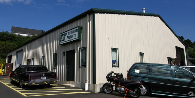

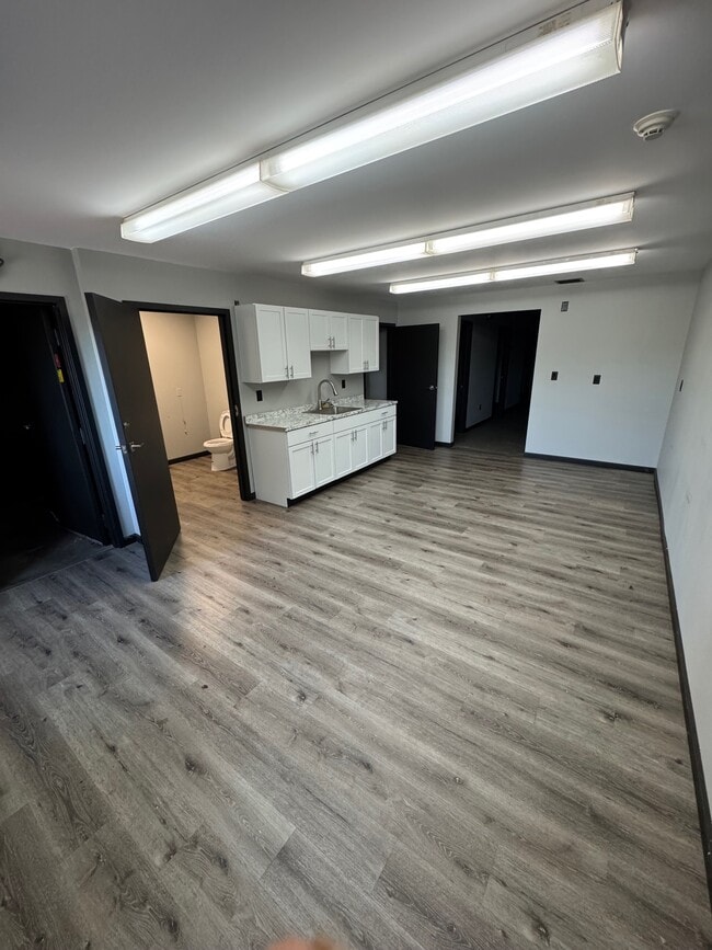
This Property Is For Sale
Property Detail
42 Crestway
HAMD-002928-000054
South Central Ct
Industrialgeneral
Connecticut
M
0000
B and X Area of moderate flood hazard, usually the area between the limits of the 100-year and 500-year floods.
0.63 AC
2024
Hamden
2025
Westchester/So Connecticut
165900
New Haven, CT
5,040 SF
NEARBY LISTINGS FOR SALE OR LEASE
DEMOGRAPHICS near 42 Crestway
1 mile
3 mile
5 mile
2025 Total Population
7,431
42,549
102,440
2030 Population
7,488
43,192
103,801
Pop Growth 2025-2030
+ 0.77%
+ 1.51%
+ 1.33%
Average Age
41
41
42
2025 Total Households
3,009
16,431
39,947
HH Growth 2025-2030
+ 0.37%
+ 1.52%
+ 1.36%
Median Household Inc
$105,488
$103,887
$95,453
Avg Household Size
2.20
2.30
2.40
2025 Avg HH Vehicles
2.00
2.00
2.00
Median Home Value
$326,003
$339,604
$339,393
Median Year Built
1988
1971
1965
Nearby Places
Map Layers
Map Styles
 Street
 Aerial
Layers
 Traffic
 Biking
Places
Listings with unknown addresses are not visible on the map
- Restaurants
- Banks
- Shops
- Fitness
- Groceries
PUBLIC TRANSPORTATION
COMMUTER RAIL
Wallingford Amtrak (Amtrak Hartford Line - Amtrak, Northeast Regional - Amtrak, Valley Flyer - Amtrak)
Drive
Walk
Distance
Wallingford Amtrak (Amtrak Hartford Line - Amtrak, Northeast Regional - Amtrak, Valley Flyer - Amtrak)
14 min
7.7 mi
Wallingford (Hartford Line - CONN DOT)
Drive
Walk
Distance
Wallingford (Hartford Line - CONN DOT)
15 min
8.1 mi
AIRPORT
Tweed/New Haven
Drive
Walk
Distance
Tweed/New Haven
23 min
12.0 mi
Freight Ports
Port of New Haven
Drive
Walk
Distance
Port of New Haven
18 min
9.2 mi
Nearby Properties
Address
Land Use
TOTAL SIZE
Lot Size
Zoning
Address
Land Use
TOTAL SIZE
Lot Size
Zoning
33,122 SF
23.06 AC
T4
Address
Land Use
TOTAL SIZE
Lot Size
Zoning
28,824 SF
44.93 AC
T4
Address
Land Use
TOTAL SIZE
Lot Size
Zoning
15.32 AC
T4
Address
Land Use
TOTAL SIZE
Lot Size
Zoning
30.46 AC
T5
Address
Land Use
TOTAL SIZE
Lot Size
Zoning
116.04 AC
R3
Address
Land Use
TOTAL SIZE
Lot Size
Zoning
18.85 AC
T5
Address
Land Use
TOTAL SIZE
Lot Size
Zoning
57,467 SF
3.72 AC
T4
Address
Land Use
TOTAL SIZE
Lot Size
Zoning
23.48 AC
T5
Address
Land Use
TOTAL SIZE
Lot Size
Zoning
10.91 AC
R5
Address
Land Use
TOTAL SIZE
Lot Size
Zoning
10.77 AC
R5
Address
Land Use
TOTAL SIZE
Lot Size
Zoning
30,272 SF
19.60 AC
R5
Address
Land Use
TOTAL SIZE
Lot Size
Zoning
8.61 AC
R5
Address
Land Use
TOTAL SIZE
Lot Size
Zoning
10.70 AC
IL30
Address
Land Use
TOTAL SIZE
Lot Size
Zoning
119,658 SF
7.48 AC
O12
Address
Land Use
TOTAL SIZE
Lot Size
Zoning
3 AC
T5
Address
Land Use
TOTAL SIZE
Lot Size
Zoning
2.86 AC
R5
Address
Land Use
TOTAL SIZE
Lot Size
Zoning
17,949 SF
8.02 AC
CB40
Address
Land Use
TOTAL SIZE
Lot Size
Zoning
318,092 SF
72.62 AC
I-2
Address
Land Use
TOTAL SIZE
Lot Size
Zoning
64,401 SF
19.16 AC
R3
Address
Land Use
TOTAL SIZE
Lot Size
Zoning
85,974 SF
7.05 AC
T-4
Address
Land Use
TOTAL SIZE
Lot Size
Zoning
123,853 SF
3.70 AC
R5
Address
Land Use
TOTAL SIZE
Lot Size
Zoning
7.04 AC
R5
Address
Land Use
TOTAL SIZE
Lot Size
Zoning
17.73 AC
IL30
Address
Land Use
TOTAL SIZE
Lot Size
Zoning
4.45 AC
CB40
Address
Land Use
TOTAL SIZE
Lot Size
Zoning
11.88 AC
T5
Address
Land Use
TOTAL SIZE
Lot Size
Zoning
59,567 SF
20.43 AC
T4
Address
Land Use
TOTAL SIZE
Lot Size
Zoning
77,042 SF
39.29 AC
R2
Address
Land Use
TOTAL SIZE
Lot Size
Zoning
8.90 AC
CB40
Address
Land Use
TOTAL SIZE
Lot Size
Zoning
9.20 AC
CB40
Address
Land Use
TOTAL SIZE
Lot Size
Zoning
51,368 SF
13 AC
R4
The World's #1 Commercial Real Estate Marketplace
Connect with us
© 2026 CoStar Group
The information above has been obtained from sources believed reliable. While we do not doubt its accuracy we have not verified it and make no guarantee, warranty or representation about it. It is your responsibility to independently confirm its accuracy and completeness. Any projections, opinions, assumptions, or estimates used are for example only and do not represent the current or future performance of the property. The value of this transaction to you depends on tax and other factors which should be evaluated by your tax, financial, and legal advisors. You and your advisors should conduct a careful, independent investigation of the property to determine to your satisfaction the suitability of the property for your needs.