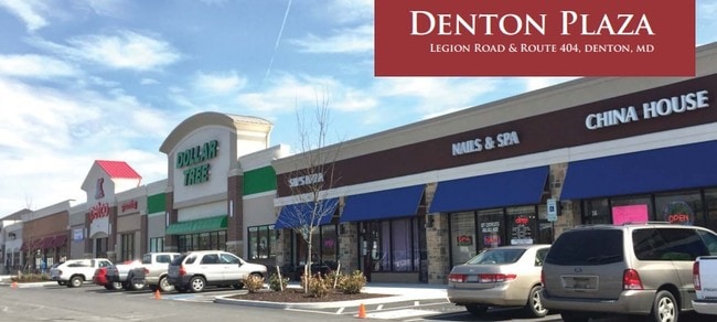
Property Record
42 Denton Plz, Denton, MD 21629
NEARBY LISTINGS FOR SALE OR LEASE
-
-
View all Denton listings for lease on LoopNet.com
Property Detail
42 Denton Plz
Storebuilding
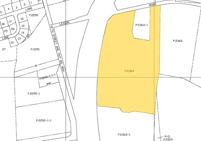
12.12 AC COR RTE 404 & LEGION RD S OF DENTON
X
Caroline
24011C0227D
Maryland
2025
12.12 AC
2025
Chesapeake Bay/Salisbury
955301
Other Market Areas
14,069 SF
03-002365
DEMOGRAPHICS near 42 Denton Plz
1 mile
3 mile
5 mile
2024 Total Population
3,309
7,551
10,351
2029 Population
3,330
7,587
10,386
Pop Growth 2024-2029
+ 0.63%
+ 0.48%
+ 0.34%
Average Age
41
40
41
2024 Total Households
1,290
2,797
3,848
HH Growth 2024-2029
+ 0.70%
+ 0.50%
+ 0.39%
Median Household Inc
$53,544
$56,953
$63,242
Avg Household Size
2.50
2.60
2.60
2024 Avg HH Vehicles
2.00
2.00
2.00
Median Home Value
$249,094
$262,011
$275,760
Median Year Built
1973
1981
1983
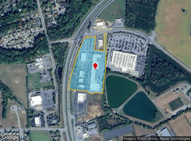
Nearby Places
Map Layers
Map Styles
 Street
 Aerial
Transit
 Traffic
 Biking
Places
Listings with unknown addresses are not visible on the map
- Restaurants
- Banks
- Shops
- Fitness
- Groceries
SALE & LEASE HISTORY
LISTING DATE
SALE/LEASE

Sep 28, 2017
For Lease
Jul 25, 2017
For Sale
Nearby Properties
Address
Land Use
TOTAL SIZE
Lot Size
Zoning
Address
Land Use
TOTAL SIZE
Lot Size
Zoning
170,095 SF
50.55 AC
R
Address
Land Use
TOTAL SIZE
Lot Size
Zoning
49,992 SF
6.05 AC
H-C
Address
Land Use
TOTAL SIZE
Lot Size
Zoning
152,426 SF
15.97 AC
RHC
Address
Land Use
TOTAL SIZE
Lot Size
Zoning
47,449 SF
3.76 AC
CM
Address
Land Use
TOTAL SIZE
Lot Size
Zoning
76,504 SF
20.04 AC
MR/TR
Address
Land Use
TOTAL SIZE
Lot Size
Zoning
20,797 SF
5.63 AC
RHC
Address
Land Use
TOTAL SIZE
Lot Size
Zoning
44,195 SF
8.28 AC
SR-R
Address
Land Use
TOTAL SIZE
Lot Size
Zoning
1,215 SF
4.36 AC
CM
Address
Land Use
TOTAL SIZE
Lot Size
Zoning
106,336 SF
6.30 AC
TR
Address
Land Use
TOTAL SIZE
Lot Size
Zoning
20,108 SF
2.52 AC
CBC
Address
Land Use
TOTAL SIZE
Lot Size
Zoning
10,720 SF
8.61 AC
SR
Address
Land Use
TOTAL SIZE
Lot Size
Zoning
4,768 SF
76.31 AC
R
Address
Land Use
TOTAL SIZE
Lot Size
Zoning
45,930 SF
5.43 AC
RHC
Address
Land Use
TOTAL SIZE
Lot Size
Zoning
15,061 SF
37.50 AC
R
Address
Land Use
TOTAL SIZE
Lot Size
Zoning
31,813 SF
5.70 AC
CBC
Address
Land Use
TOTAL SIZE
Lot Size
Zoning
7,559 SF
1.07 AC
CBC
Address
Land Use
TOTAL SIZE
Lot Size
Zoning
22,489 SF
2.90 AC
RHC
Address
Land Use
TOTAL SIZE
Lot Size
Zoning
20,338 SF
0.78 AC
CBC
Address
Land Use
TOTAL SIZE
Lot Size
Zoning
64,429 SF
8.80 AC
LI
Address
Land Use
TOTAL SIZE
Lot Size
Zoning
4,200 SF
4.79 AC
TR
Address
Land Use
TOTAL SIZE
Lot Size
Zoning
3,678 SF
8.20 AC
MR
Address
Land Use
TOTAL SIZE
Lot Size
Zoning
99,200 SF
6.11 AC
LI
Address
Land Use
TOTAL SIZE
Lot Size
Zoning
28,982 SF
1.43 AC
RHC
Address
Land Use
TOTAL SIZE
Lot Size
Zoning
2,993 SF
6.15 AC
H-C
Address
Land Use
TOTAL SIZE
Lot Size
Zoning
5,260 SF
8.72 AC
C2
Address
Land Use
TOTAL SIZE
Lot Size
Zoning
7,614 SF
0.47 AC
CBC
Address
Land Use
TOTAL SIZE
Lot Size
Zoning
20,336 SF
0.22 AC
CBC
Address
Land Use
TOTAL SIZE
Lot Size
Zoning
3,360 SF
10.59 AC
SR
Address
Land Use
TOTAL SIZE
Lot Size
Zoning
90,772 SF
5.85 AC
LI
The World's #1 Commercial Real Estate Marketplace
Connect with us
© 2026 CoStar Group
The information above has been obtained from sources believed reliable. While we do not doubt its accuracy we have not verified it and make no guarantee, warranty or representation about it. It is your responsibility to independently confirm its accuracy and completeness. Any projections, opinions, assumptions, or estimates used are for example only and do not represent the current or future performance of the property. The value of this transaction to you depends on tax and other factors which should be evaluated by your tax, financial, and legal advisors. You and your advisors should conduct a careful, independent investigation of the property to determine to your satisfaction the suitability of the property for your needs.