Property Record
42 Dock Rd, Remsenburg, NY 11960
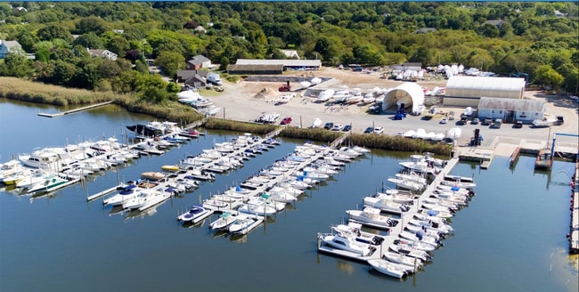
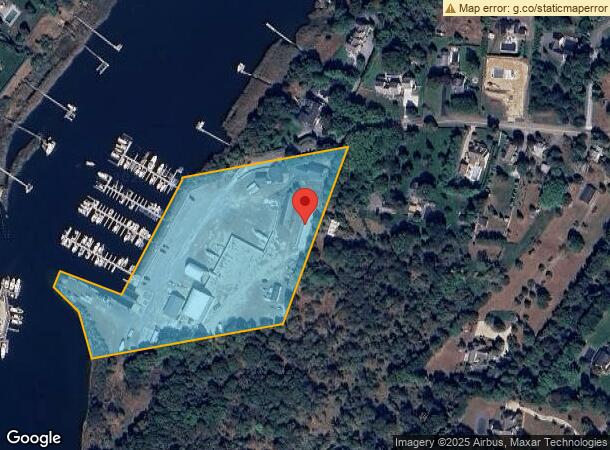
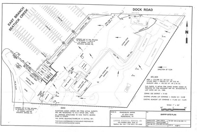
This Property Is For Sale
NEARBY LISTINGS FOR SALE OR LEASE
Property Detail
42 Dock Rd
0900-366-00-01-00-003-000
87 REV CTR LD -6000
Marinafacility
Suffolk
AE
New York
36103C0753H
3
0
6.19 AC
2024
Eastern Suffolk
190503
Long Island (New York)
1,984 SF
Nassau County-Suffolk County, NY
DEMOGRAPHICS near 42 Dock Rd
1 Mile
3 Mile
5 Mile
2024 Total Population
2,533
16,528
39,759
2029 Population
2,465
16,604
40,414
Pop Growth 2024-2029
(2.68%)
+ 0.46%
+ 1.65%
Average Age
43
44
43
2024 Total Households
939
5,935
14,279
HH Growth 2024-2029
(2.88%)
+ 0.29%
+ 1.79%
Median Household Inc
$139,285
$124,613
$120,186
Avg Household Size
2.60
2.70
2.70
2024 Avg HH Vehicles
2.00
2.00
2.00
Median Home Value
$701,814
$733,209
$691,306
Median Year Built
1975
1982
1983
Nearby Places
Map Layers
Map Styles
 Street
 Aerial
- Restaurants
- Banks
- Shops
- Fitness
- Groceries
PUBLIC TRANSPORTATION
COMMUTER RAIL
Speonk Station (Montauk Branch - Long Island Rail Road)
DRIVE
WALK
Distance
Speonk Station (Montauk Branch - Long Island Rail Road)
3 min
1.1 mi
Westhampton Station (Montauk Branch - Long Island Rail Road)
DRIVE
WALK
Distance
Westhampton Station (Montauk Branch - Long Island Rail Road)
10 min
5.0 mi
AIRPORT
Long Island MacArthur
DRIVE
WALK
Distance
Long Island MacArthur
37 min
23.3 mi
Freight Ports
Port of New Haven
DRIVE
WALK
Distance
Port of New Haven
153 min
63.8 mi
Nearby Properties
Address
Land Use
TOTAL SIZE
Lot Size
Zoning
Address
Land Use
TOTAL SIZE
Lot Size
Zoning
200 SF
67.80 AC
CR200
Address
Land Use
TOTAL SIZE
Lot Size
Zoning
68,676 SF
9.70 AC
CR200
Address
Land Use
TOTAL SIZE
Lot Size
Zoning
18.28 AC
CR200
Address
Land Use
TOTAL SIZE
Lot Size
Zoning
15,084 SF
10.25 AC
R40
Address
Land Use
TOTAL SIZE
Lot Size
Zoning
26,824 SF
146.40 AC
CR200
Address
Land Use
TOTAL SIZE
Lot Size
Zoning
87,569 SF
19 AC
R120
Address
Land Use
TOTAL SIZE
Lot Size
Zoning
28.62 AC
R40
Address
Land Use
TOTAL SIZE
Lot Size
Zoning
16.50 AC
VILLA
Address
Land Use
TOTAL SIZE
Lot Size
Zoning
30,512 SF
4.28 AC
VB
Address
Land Use
TOTAL SIZE
Lot Size
Zoning
16,854 SF
11.95 AC
OD
Address
Land Use
TOTAL SIZE
Lot Size
Zoning
92.10 AC
CR200
Address
Land Use
TOTAL SIZE
Lot Size
Zoning
8,636 SF
1.55 AC
R40
Address
Land Use
TOTAL SIZE
Lot Size
Zoning
9,069 SF
4.19 AC
R60
Address
Land Use
TOTAL SIZE
Lot Size
Zoning
7.40 AC
R40
Address
Land Use
TOTAL SIZE
Lot Size
Zoning
90.50 AC
CR200
Address
Land Use
TOTAL SIZE
Lot Size
Zoning
78.40 AC
CR200
Address
Land Use
TOTAL SIZE
Lot Size
Zoning
6,875 SF
2.90 AC
R80
Address
Land Use
TOTAL SIZE
Lot Size
Zoning
5,122 SF
0.55 AC
VILLA
Address
Land Use
TOTAL SIZE
Lot Size
Zoning
8,098 SF
3 AC
R40
Address
Land Use
TOTAL SIZE
Lot Size
Zoning
5,150 SF
2.50 AC
R80
Address
Land Use
TOTAL SIZE
Lot Size
Zoning
6,975 SF
0.92 AC
R40
Address
Land Use
TOTAL SIZE
Lot Size
Zoning
12,230 SF
1.88 AC
R40
Address
Land Use
TOTAL SIZE
Lot Size
Zoning
40,190 SF
4.89 AC
LI40
Address
Land Use
TOTAL SIZE
Lot Size
Zoning
6,368 SF
1.23 AC
R40
Address
Land Use
TOTAL SIZE
Lot Size
Zoning
5,897 SF
1.48 AC
R40
Address
Land Use
TOTAL SIZE
Lot Size
Zoning
11,740 SF
2.75 AC
HB
Address
Land Use
TOTAL SIZE
Lot Size
Zoning
16,654 SF
1.64 AC
R40
Address
Land Use
TOTAL SIZE
Lot Size
Zoning
607,016 SF
8.41 AC
LI40
Address
Land Use
TOTAL SIZE
Lot Size
Zoning
8,282 SF
4.41 AC
R40
The World's #1 Commercial Real Estate Marketplace
Connect with us
© 2025 CoStar Group
The information above has been obtained from sources believed reliable. While we do not doubt its accuracy we have not verified it and make no guarantee, warranty or representation about it. It is your responsibility to independently confirm its accuracy and completeness. Any projections, opinions, assumptions, or estimates used are for example only and do not represent the current or future performance of the property. The value of this transaction to you depends on tax and other factors which should be evaluated by your tax, financial, and legal advisors. You and your advisors should conduct a careful, independent investigation of the property to determine to your satisfaction the suitability of the property for your needs.