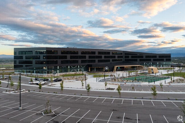
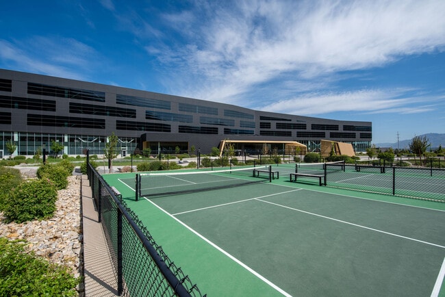
Property Record
42 E Future Way, Draper, UT 84020
Current Lease Availabilities
Property Detail
42 E Future Way
34-07-300-020-0000
LOT 7, PLURALSIGHT SUBDIVISION
Officebuilding
Salt Lake
RM2
Utah
B and X Area of moderate flood hazard, usually the area between the limits of the 100-year and 500-year floods.
7
2024
2.81 AC
2025
Draper
112830
Salt Lake City
70,379 SF
Salt Lake City-Murray, UT
NEARBY LISTINGS FOR SALE OR LEASE
DEMOGRAPHICS near 42 E Future Way
1 mile
3 mile
5 mile
2025 Total Population
8,091
56,134
164,412
2030 Population
8,403
58,540
172,418
Pop Growth 2025-2030
+ 3.86%
+ 4.29%
+ 4.87%
Average Age
37
35
35
2025 Total Households
2,860
16,187
48,439
HH Growth 2025-2030
+ 4.16%
+ 4.76%
+ 5.07%
Median Household Inc
$132,671
$133,120
$129,686
Avg Household Size
2.80
3.30
3.30
2025 Avg HH Vehicles
2.00
2.00
2.00
Median Home Value
$761,579
$792,902
$746,983
Median Year Built
2005
2008
2004
Nearby Places
Map Layers
Map Styles
 Street
 Aerial
Transit
 Traffic
 Biking
Places
Listings with unknown addresses are not visible on the map
- Restaurants
- Banks
- Shops
- Fitness
- Groceries
PUBLIC TRANSPORTATION
COMMUTER RAIL
Draper Station (FrontRunner - Utah Transit Authority (UTA))
Drive
Walk
Distance
Draper Station (FrontRunner - Utah Transit Authority (UTA))
8 min
3.4 mi
Lehi Station (FrontRunner - Utah Transit Authority (UTA))
Drive
Walk
Distance
Lehi Station (FrontRunner - Utah Transit Authority (UTA))
10 min
5.9 mi
AIRPORT
Salt Lake City International
Drive
Walk
Distance
Salt Lake City International
31 min
25.4 mi
Provo Municipal
Drive
Walk
Distance
Provo Municipal
36 min
26.6 mi
Freight Ports
Port of Stockton
Drive
Walk
Distance
Port of Stockton
731 min
715.8 mi
Nearby Properties
Address
Land Use
TOTAL SIZE
Lot Size
Zoning
Address
Land Use
TOTAL SIZE
Lot Size
Zoning
161,466 SF
624.79 AC
M-1
Address
Land Use
TOTAL SIZE
Lot Size
Zoning
40,495 SF
33.28 AC
RM-1
Address
Land Use
TOTAL SIZE
Lot Size
Zoning
774,515 SF
87.50 AC
M-1
Address
Land Use
TOTAL SIZE
Lot Size
Zoning
1,055,572 SF
8.31 AC
CR
Address
Land Use
TOTAL SIZE
Lot Size
Zoning
210,421 SF
6.87 AC
CR
Address
Land Use
TOTAL SIZE
Lot Size
Zoning
392,144 SF
30.63 AC
1113
Address
Land Use
TOTAL SIZE
Lot Size
Zoning
423,208 SF
8.07 AC
CSD-H
Address
Land Use
TOTAL SIZE
Lot Size
Zoning
359,628 SF
4.53 AC
TSD
Address
Land Use
TOTAL SIZE
Lot Size
Zoning
187,621 SF
3.64 AC
1103
Address
Land Use
TOTAL SIZE
Lot Size
Zoning
99,144 SF
6.23 AC
HC
Address
Land Use
TOTAL SIZE
Lot Size
Zoning
126,531 SF
11.50 AC
1244
Address
Land Use
TOTAL SIZE
Lot Size
Zoning
65,664 SF
16.47 AC
RM2
Address
Land Use
TOTAL SIZE
Lot Size
Zoning
391,078 SF
5.78 AC
IC
Address
Land Use
TOTAL SIZE
Lot Size
Zoning
416,562 SF
7.48 AC
CSDDPM
Address
Land Use
TOTAL SIZE
Lot Size
Zoning
81,925 SF
10.13 AC
MU
Address
Land Use
TOTAL SIZE
Lot Size
Zoning
115,637 SF
36.38 AC
TSD
Address
Land Use
TOTAL SIZE
Lot Size
Zoning
374,097 SF
6.87 AC
CSDDPM
Address
Land Use
TOTAL SIZE
Lot Size
Zoning
130,809 SF
16.13 AC
RM 1
Address
Land Use
TOTAL SIZE
Lot Size
Zoning
247,899 SF
9.20 AC
TSD
Address
Land Use
TOTAL SIZE
Lot Size
Zoning
296,237 SF
6.45 AC
TSD
Address
Land Use
TOTAL SIZE
Lot Size
Zoning
353,500 SF
29.38 AC
CR
Address
Land Use
TOTAL SIZE
Lot Size
Zoning
255,090 SF
17.91 AC
CSDDRC
Address
Land Use
TOTAL SIZE
Lot Size
Zoning
408,208 SF
5.20 AC
DC
Address
Land Use
TOTAL SIZE
Lot Size
Zoning
77,905 SF
7.15 AC
CO2
Address
Land Use
TOTAL SIZE
Lot Size
Zoning
76,420 SF
14.22 AC
RM-2
Address
Land Use
TOTAL SIZE
Lot Size
Zoning
319,222 SF
6.12 AC
CSD-DD
Address
Land Use
TOTAL SIZE
Lot Size
Zoning
249.04 AC
OS
Address
Land Use
TOTAL SIZE
Lot Size
Zoning
53,777 SF
229.36 AC
SF-1
Address
Land Use
TOTAL SIZE
Lot Size
Zoning
179,860 SF
11.50 AC
M-1
Address
Land Use
TOTAL SIZE
Lot Size
Zoning
198.67 AC
4280
The World's #1 Commercial Real Estate Marketplace
Connect with us
© 2026 CoStar Group
The information above has been obtained from sources believed reliable. While we do not doubt its accuracy we have not verified it and make no guarantee, warranty or representation about it. It is your responsibility to independently confirm its accuracy and completeness. Any projections, opinions, assumptions, or estimates used are for example only and do not represent the current or future performance of the property. The value of this transaction to you depends on tax and other factors which should be evaluated by your tax, financial, and legal advisors. You and your advisors should conduct a careful, independent investigation of the property to determine to your satisfaction the suitability of the property for your needs.