Property Record
42 Henderson St, Oxford, NJ 07863
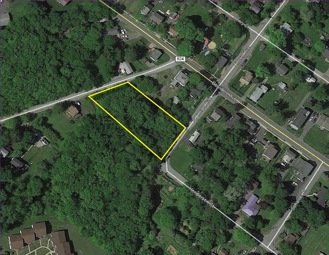
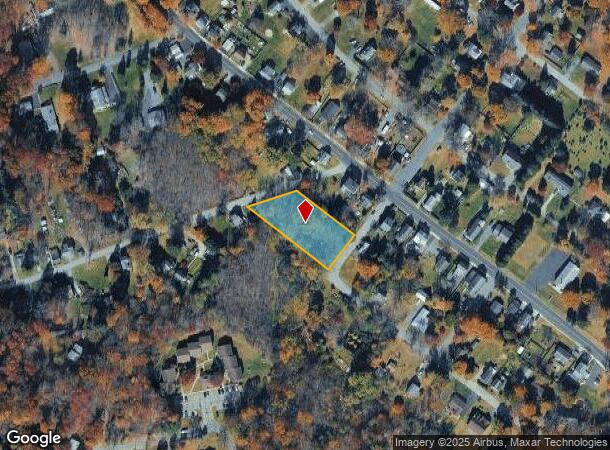
This Property Is For Sale
NEARBY LISTINGS FOR SALE OR LEASE
-
-
No Photo
-
View all Oxford listings for sale on LoopNet.com
Property Detail
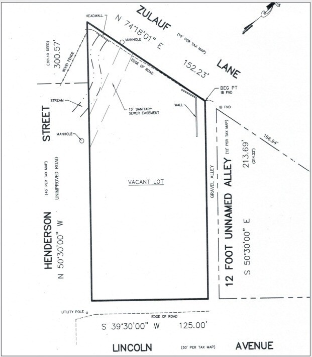
42 Henderson St
17-00015-0000-00003
Warren
Vacantlandnec
New Jersey
X
3
34041C0220E
0.89 AC
2024
Warren County
2025
Northern New Jersey
031602
Allentown-Bethlehem-Easton, PA-NJ
DEMOGRAPHICS near 42 Henderson St
1 Mile
3 Mile
5 Mile
2024 Total Population
1,281
8,321
26,848
2029 Population
1,303
8,500
27,380
Pop Growth 2024-2029
+ 1.72%
+ 2.15%
+ 1.98%
Average Age
43
45
45
2024 Total Households
514
3,304
10,927
HH Growth 2024-2029
+ 1.75%
+ 2.15%
+ 1.92%
Median Household Inc
$70,146
$79,669
$77,056
Avg Household Size
2.50
2.50
2.40
2024 Avg HH Vehicles
2.00
2.00
2.00
Median Home Value
$231,428
$290,178
$278,320
Median Year Built
1959
1979
1970
Nearby Places
Map Layers
Map Styles
 Street
 Aerial
- Restaurants
- Banks
- Shops
- Fitness
- Groceries
PUBLIC TRANSPORTATION
AIRPORT
Lehigh Valley International
DRIVE
WALK
Distance
Lehigh Valley International
50 min
30.3 mi
Freight Ports
New York Container Terminal
DRIVE
WALK
Distance
New York Container Terminal
78 min
60.7 mi
Nearby Properties
Address
Land Use
TOTAL SIZE
Lot Size
Zoning
Address
Land Use
TOTAL SIZE
Lot Size
Zoning
46.85 AC
R-40
Address
Land Use
TOTAL SIZE
Lot Size
Zoning
4 AC
R10
Address
Land Use
TOTAL SIZE
Lot Size
Zoning
11.69 AC
I
Address
Land Use
TOTAL SIZE
Lot Size
Zoning
800 SF
3.73 AC
Address
Land Use
TOTAL SIZE
Lot Size
Zoning
15.80 AC
I
Address
Land Use
TOTAL SIZE
Lot Size
Zoning
877.15 AC
Address
Land Use
TOTAL SIZE
Lot Size
Zoning
Address
Land Use
TOTAL SIZE
Lot Size
Zoning
3.16 AC
R80
Address
Land Use
TOTAL SIZE
Lot Size
Zoning
548.78 AC
R-80
Address
Land Use
TOTAL SIZE
Lot Size
Zoning
217.87 AC
Address
Land Use
TOTAL SIZE
Lot Size
Zoning
7.93 AC
R4
Address
Land Use
TOTAL SIZE
Lot Size
Zoning
310.41 AC
Address
Land Use
TOTAL SIZE
Lot Size
Zoning
5,696 SF
2.56 AC
Address
Land Use
TOTAL SIZE
Lot Size
Zoning
55.52 AC
LI
Address
Land Use
TOTAL SIZE
Lot Size
Zoning
1,800 SF
9.75 AC
Address
Land Use
TOTAL SIZE
Lot Size
Zoning
46.04 AC
Address
Land Use
TOTAL SIZE
Lot Size
Zoning
7,767 SF
5.02 AC
GC
Address
Land Use
TOTAL SIZE
Lot Size
Zoning
2,226 SF
0.88 AC
R10
Address
Land Use
TOTAL SIZE
Lot Size
Zoning
63 AC
R80
Address
Land Use
TOTAL SIZE
Lot Size
Zoning
91.05 AC
Address
Land Use
TOTAL SIZE
Lot Size
Zoning
5 AC
GC
Address
Land Use
TOTAL SIZE
Lot Size
Zoning
19.05 AC
Address
Land Use
TOTAL SIZE
Lot Size
Zoning
2,546 SF
4.50 AC
R-40
Address
Land Use
TOTAL SIZE
Lot Size
Zoning
88.48 AC
Address
Land Use
TOTAL SIZE
Lot Size
Zoning
36.34 AC
Address
Land Use
TOTAL SIZE
Lot Size
Zoning
8,568 SF
1.64 AC
B
Address
Land Use
TOTAL SIZE
Lot Size
Zoning
5,394 SF
1.93 AC
R120
Address
Land Use
TOTAL SIZE
Lot Size
Zoning
33.44 AC
Address
Land Use
TOTAL SIZE
Lot Size
Zoning
2,680 SF
5.17 AC
R10
Address
Land Use
TOTAL SIZE
Lot Size
Zoning
166.33 AC
A200
The World's #1 Commercial Real Estate Marketplace
Connect with us
© 2025 CoStar Group
The information above has been obtained from sources believed reliable. While we do not doubt its accuracy we have not verified it and make no guarantee, warranty or representation about it. It is your responsibility to independently confirm its accuracy and completeness. Any projections, opinions, assumptions, or estimates used are for example only and do not represent the current or future performance of the property. The value of this transaction to you depends on tax and other factors which should be evaluated by your tax, financial, and legal advisors. You and your advisors should conduct a careful, independent investigation of the property to determine to your satisfaction the suitability of the property for your needs.