Property Record
42 Jagger Mill Rd, Sanford, ME 04073
NEARBY LISTINGS FOR SALE OR LEASE
-
-
View all Sanford listings for sale on LoopNet.com
Property Detail
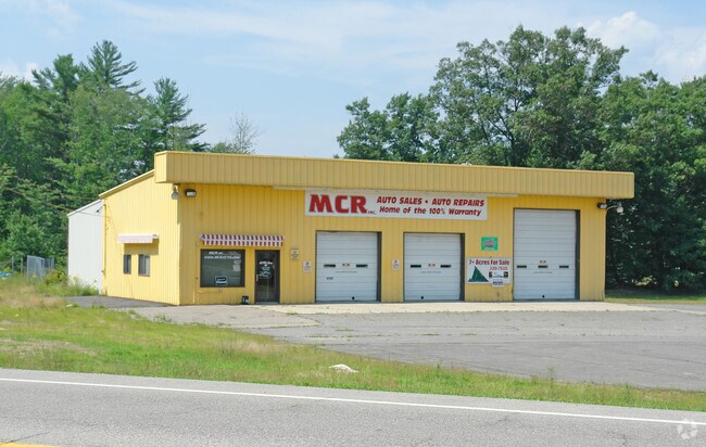
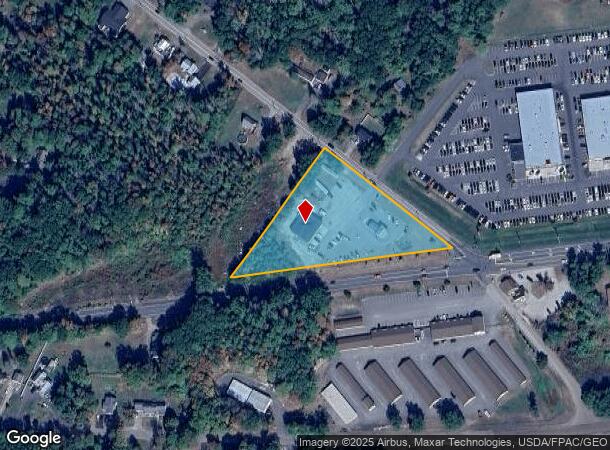
42 Jagger Mill Rd
Autorepair
York
X
Maine
23031C0413G
2.41 AC
2025
York County
2025
Portland/South Portland
030300
Portland-South Portland, ME
4,340 SF
SANF-000015A-R000018
DEMOGRAPHICS near 42 Jagger Mill Rd
1 Mile
3 Mile
5 Mile
2024 Total Population
724
7,249
23,706
2029 Population
759
7,631
24,983
Pop Growth 2024-2029
+ 4.83%
+ 5.27%
+ 5.39%
Average Age
46
44
42
2024 Total Households
353
3,031
9,681
HH Growth 2024-2029
+ 4.82%
+ 5.18%
+ 5.31%
Median Household Inc
$43,699
$68,839
$68,187
Avg Household Size
2.00
2.30
2.40
2024 Avg HH Vehicles
2.00
2.00
2.00
Median Home Value
$216,379
$255,804
$258,847
Median Year Built
1987
1981
1977
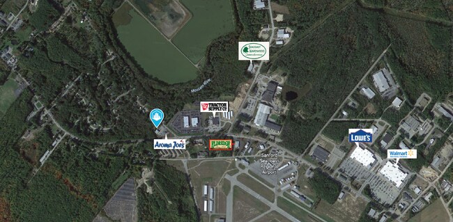
Nearby Places
Map Layers
Map Styles
 Street
 Aerial
- Restaurants
- Banks
- Shops
- Fitness
- Groceries
PUBLIC TRANSPORTATION
COMMUTER RAIL
Wells (Downeaster - Amtrak)
DRIVE
WALK
Distance
Wells (Downeaster - Amtrak)
15 min
8.3 mi
AIRPORT
Portsmouth International at Pease
DRIVE
WALK
Distance
Portsmouth International at Pease
44 min
31.0 mi
Portland International Jetport
DRIVE
WALK
Distance
Portland International Jetport
45 min
33.3 mi
Freight Ports
Portland, ME
DRIVE
WALK
Distance
Portland, ME
46 min
35.9 mi
SALE & LEASE HISTORY
LISTING DATE
SALE/LEASE

Jan 31, 2024
For Sale
Jan 12, 2023
For Lease
Nearby Properties
Address
Land Use
TOTAL SIZE
Lot Size
Zoning
Address
Land Use
TOTAL SIZE
Lot Size
Zoning
220,000 SF
137 AC
GR
Address
Land Use
TOTAL SIZE
Lot Size
Zoning
450 AC
RMU
Address
Land Use
TOTAL SIZE
Lot Size
Zoning
198,252 SF
21.38 AC
IB
Address
Land Use
TOTAL SIZE
Lot Size
Zoning
283,350 SF
17.14 AC
AD
Address
Land Use
TOTAL SIZE
Lot Size
Zoning
30.33 AC
SB
Address
Land Use
TOTAL SIZE
Lot Size
Zoning
101 AC
IB
Address
Land Use
TOTAL SIZE
Lot Size
Zoning
134,480 SF
15.35 AC
IB
Address
Land Use
TOTAL SIZE
Lot Size
Zoning
1,271.85 AC
DZ
Address
Land Use
TOTAL SIZE
Lot Size
Zoning
24,959 SF
19.77 AC
IB
Address
Land Use
TOTAL SIZE
Lot Size
Zoning
9 AC
GR
Address
Land Use
TOTAL SIZE
Lot Size
Zoning
6.81 AC
Address
Land Use
TOTAL SIZE
Lot Size
Zoning
6.71 AC
SB
Address
Land Use
TOTAL SIZE
Lot Size
Zoning
4.08 AC
IB
Address
Land Use
TOTAL SIZE
Lot Size
Zoning
2.59 AC
Address
Land Use
TOTAL SIZE
Lot Size
Zoning
107.11 AC
AD
Address
Land Use
TOTAL SIZE
Lot Size
Zoning
14,044 SF
2.62 AC
CC
Address
Land Use
TOTAL SIZE
Lot Size
Zoning
25.50 AC
AD
Address
Land Use
TOTAL SIZE
Lot Size
Zoning
4.09 AC
IB
Address
Land Use
TOTAL SIZE
Lot Size
Zoning
2.65 AC
CC
Address
Land Use
TOTAL SIZE
Lot Size
Zoning
92,944 SF
19.38 AC
SB
Address
Land Use
TOTAL SIZE
Lot Size
Zoning
4.72 AC
SFR
Address
Land Use
TOTAL SIZE
Lot Size
Zoning
26,748 SF
1.20 AC
Address
Land Use
TOTAL SIZE
Lot Size
Zoning
7,469 SF
5.04 AC
IB
Address
Land Use
TOTAL SIZE
Lot Size
Zoning
89,638 SF
10.05 AC
IB
Address
Land Use
TOTAL SIZE
Lot Size
Zoning
3.64 AC
UB
Address
Land Use
TOTAL SIZE
Lot Size
Zoning
4 AC
GR
Address
Land Use
TOTAL SIZE
Lot Size
Zoning
7,200 SF
5.33 AC
SB
Address
Land Use
TOTAL SIZE
Lot Size
Zoning
2.33 AC
CC
Address
Land Use
TOTAL SIZE
Lot Size
Zoning
3,360 SF
4.30 AC
RD
Address
Land Use
TOTAL SIZE
Lot Size
Zoning
28.15 AC
The World's #1 Commercial Real Estate Marketplace
Connect with us
© 2025 CoStar Group
The information above has been obtained from sources believed reliable. While we do not doubt its accuracy we have not verified it and make no guarantee, warranty or representation about it. It is your responsibility to independently confirm its accuracy and completeness. Any projections, opinions, assumptions, or estimates used are for example only and do not represent the current or future performance of the property. The value of this transaction to you depends on tax and other factors which should be evaluated by your tax, financial, and legal advisors. You and your advisors should conduct a careful, independent investigation of the property to determine to your satisfaction the suitability of the property for your needs.