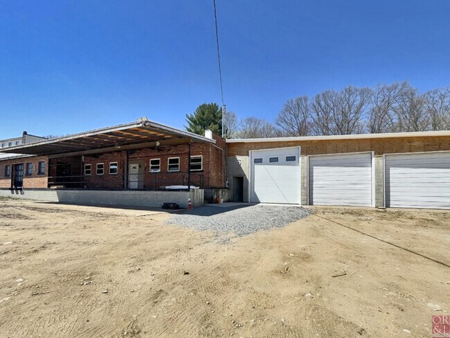
Property Record
42 Natchaug St, Willimantic, CT 06226

NEARBY LISTINGS FOR SALE OR LEASE
Property Detail
42 Natchaug St
Worcester, MA-CT
Windham
WIND M:14-03 B:124 L:5-2
Connecticut
Commercialbuilding
5-2
2025
5.96 AC
2025
Windham County
800600
Hartford
7,109 SF
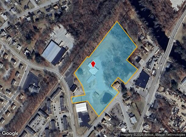
DEMOGRAPHICS near 42 Natchaug St
1 Mile
3 Mile
5 Mile
2024 Total Population
10,042
27,072
35,668
2029 Population
9,976
27,099
35,634
Pop Growth 2024-2029
(0.66%)
+ 0.10%
(0.10%)
Average Age
36
37
39
2024 Total Households
3,985
9,892
13,322
HH Growth 2024-2029
(0.78%)
(0.03%)
(0.22%)
Median Household Inc
$40,992
$49,506
$55,116
Avg Household Size
2.40
2.30
2.40
2024 Avg HH Vehicles
1.00
2.00
2.00
Median Home Value
$163,179
$177,949
$209,243
Median Year Built
1949
1961
1964
Nearby Places
Map Layers
Map Styles
 Street
 Aerial
- Restaurants
- Banks
- Shops
- Fitness
- Groceries
PUBLIC TRANSPORTATION
AIRPORT
Bradley International
DRIVE
WALK
Distance
Bradley International
63 min
42.0 mi
Freight Ports
Port of Davisville, RI
DRIVE
WALK
Distance
Port of Davisville, RI
83 min
60.4 mi
SALE & LEASE HISTORY
LISTING DATE
SALE/LEASE

May 03, 2023
For Lease
Nearby Properties
Address
Land Use
TOTAL SIZE
Lot Size
Zoning
Address
Land Use
TOTAL SIZE
Lot Size
Zoning
14.62 AC
B4
Address
Land Use
TOTAL SIZE
Lot Size
Zoning
47,712 SF
1 AC
I
Address
Land Use
TOTAL SIZE
Lot Size
Zoning
176,832 SF
I
Address
Land Use
TOTAL SIZE
Lot Size
Zoning
33,366 SF
R6
Address
Land Use
TOTAL SIZE
Lot Size
Zoning
Address
Land Use
TOTAL SIZE
Lot Size
Zoning
145,144 SF
R6
Address
Land Use
TOTAL SIZE
Lot Size
Zoning
127,472 SF
R6
Address
Land Use
TOTAL SIZE
Lot Size
Zoning
14.50 AC
R20
Address
Land Use
TOTAL SIZE
Lot Size
Zoning
111,757 SF
6.74 AC
RL
Address
Land Use
TOTAL SIZE
Lot Size
Zoning
90,450 SF
R6
Address
Land Use
TOTAL SIZE
Lot Size
Zoning
99,901 SF
1 AC
I
Address
Land Use
TOTAL SIZE
Lot Size
Zoning
61,837 SF
I
Address
Land Use
TOTAL SIZE
Lot Size
Zoning
73,691 SF
R6
Address
Land Use
TOTAL SIZE
Lot Size
Zoning
102,324 SF
1 AC
I
Address
Land Use
TOTAL SIZE
Lot Size
Zoning
99,139 SF
R6
Address
Land Use
TOTAL SIZE
Lot Size
Zoning
86,899 SF
18.27 AC
R3
Address
Land Use
TOTAL SIZE
Lot Size
Zoning
68,508 SF
R6
Address
Land Use
TOTAL SIZE
Lot Size
Zoning
316,812 SF
39.88 AC
R4
Address
Land Use
TOTAL SIZE
Lot Size
Zoning
57,648 SF
R6
Address
Land Use
TOTAL SIZE
Lot Size
Zoning
22.30 AC
RL
Address
Land Use
TOTAL SIZE
Lot Size
Zoning
28,231 SF
R6
Address
Land Use
TOTAL SIZE
Lot Size
Zoning
126,220 SF
1 AC
I
Address
Land Use
TOTAL SIZE
Lot Size
Zoning
158,766 SF
3.91 AC
R6
Address
Land Use
TOTAL SIZE
Lot Size
Zoning
86,684 SF
1 AC
I
Address
Land Use
TOTAL SIZE
Lot Size
Zoning
152 AC
I
Address
Land Use
TOTAL SIZE
Lot Size
Zoning
24,313 SF
R6
Address
Land Use
TOTAL SIZE
Lot Size
Zoning
275,230 SF
27.63 AC
PB1
Address
Land Use
TOTAL SIZE
Lot Size
Zoning
200 AC
R2 - 1
Address
Land Use
TOTAL SIZE
Lot Size
Zoning
6,340 SF
I
Address
Land Use
TOTAL SIZE
Lot Size
Zoning
63,224 SF
2.68 AC
R6
The World's #1 Commercial Real Estate Marketplace
Connect with us
© 2025 CoStar Group
The information above has been obtained from sources believed reliable. While we do not doubt its accuracy we have not verified it and make no guarantee, warranty or representation about it. It is your responsibility to independently confirm its accuracy and completeness. Any projections, opinions, assumptions, or estimates used are for example only and do not represent the current or future performance of the property. The value of this transaction to you depends on tax and other factors which should be evaluated by your tax, financial, and legal advisors. You and your advisors should conduct a careful, independent investigation of the property to determine to your satisfaction the suitability of the property for your needs.