Property Record
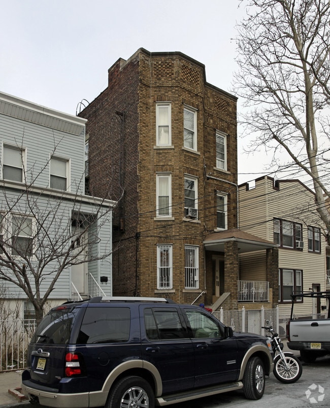
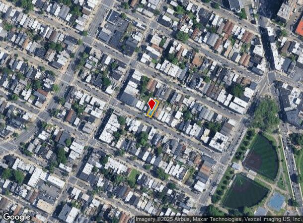
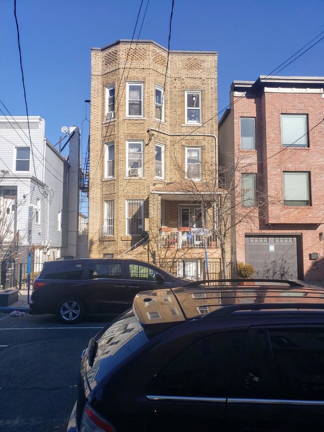
42 Poplar St, Jersey City, NJ 07307
This Property Is For Sale
NEARBY LISTINGS FOR SALE OR LEASE
Property Detail
42 Poplar St
06-00802-0000-00043
Hudson
Apartment
New Jersey
X
43
34003C0268H
0.06 AC
2024
The Heights
2025
Northern New Jersey
000200
New York-Jersey City-White Plains, NY-NJ
DEMOGRAPHICS near 42 Poplar St
1 Mile
3 Mile
5 Mile
2024 Total Population
99,160
589,386
1,570,797
2029 Population
94,945
566,335
1,480,298
Pop Growth 2024-2029
(4.25%)
(3.91%)
(5.76%)
Average Age
37
38
40
2024 Total Households
39,083
268,719
746,537
HH Growth 2024-2029
(4.56%)
(4.36%)
(6.13%)
Median Household Inc
$83,835
$100,031
$104,315
Avg Household Size
2.40
2.10
2.00
2024 Avg HH Vehicles
1.00
1.00
.00
Median Home Value
$595,147
$722,434
$854,709
Median Year Built
1957
1966
1959
Nearby Places
- Restaurants
- Banks
- Shops
- Fitness
- Groceries
PUBLIC TRANSPORTATION
TRANSIT/SUBWAY
9th Street - Congress Center (Tonnelle Avenue-Hoboken Terminal - Hudson-Bergen Light Rail (Hudson-Bergen Light Rail), West Side Avenue-Tonnelle Avenue - Hudson-Bergen Light Rail (Hudson-Bergen Light Rail))
DRIVE
WALK
Distance
9th Street - Congress Center (Tonnelle Avenue-Hoboken Terminal - Hudson-Bergen Light Rail (Hudson-Bergen Light Rail), West Side Avenue-Tonnelle Avenue - Hudson-Bergen Light Rail (Hudson-Bergen Light Rail))
7 min
14 min
0.7 mi
COMMUTER RAIL
Hoboken (Hoboken-33rd Street - Port Authority Trans-Hudson (PATH), Hoboken-World Trade Center - Port Authority Trans-Hudson (PATH))
DRIVE
WALK
Distance
Hoboken (Hoboken-33rd Street - Port Authority Trans-Hudson (PATH), Hoboken-World Trade Center - Port Authority Trans-Hudson (PATH))
8 min
2.2 mi
Journal Square (Journal Square-33rd Street - Port Authority Trans-Hudson (PATH), Newark Penn Station-World Trade Center - Port Authority Trans-Hudson (PATH))
DRIVE
WALK
Distance
Journal Square (Journal Square-33rd Street - Port Authority Trans-Hudson (PATH), Newark Penn Station-World Trade Center - Port Authority Trans-Hudson (PATH))
6 min
2.2 mi
AIRPORT
Newark Liberty International
DRIVE
WALK
Distance
Newark Liberty International
16 min
11.5 mi
LaGuardia
DRIVE
WALK
Distance
LaGuardia
31 min
13.2 mi
John F Kennedy International
DRIVE
WALK
Distance
John F Kennedy International
40 min
21.3 mi
Freight Ports
NY - Red Hook Container Terminal
DRIVE
WALK
Distance
NY - Red Hook Container Terminal
21 min
8.4 mi
Nearby Properties
Address
Land Use
TOTAL SIZE
Lot Size
Zoning
Address
Land Use
TOTAL SIZE
Lot Size
Zoning
4,060,596 SF
22.09 AC
M2-3
Address
Land Use
TOTAL SIZE
Lot Size
Zoning
2,521,850 SF
1.59 AC
C6-4
Address
Land Use
TOTAL SIZE
Lot Size
Zoning
1,445,092 SF
3.10 AC
C6-4
Address
Land Use
TOTAL SIZE
Lot Size
Zoning
2,221,336 SF
1.55 AC
C6-4
Address
Land Use
TOTAL SIZE
Lot Size
Zoning
9.33 AC
C-1
Address
Land Use
TOTAL SIZE
Lot Size
Zoning
2,161,994 SF
3.79 AC
M1-5
Address
Land Use
TOTAL SIZE
Lot Size
Zoning
2,354,289 SF
3.96 AC
C6-4
Address
Land Use
TOTAL SIZE
Lot Size
Zoning
1,048,620 SF
5.67 AC
C6-4
Address
Land Use
TOTAL SIZE
Lot Size
Zoning
1,946,157 SF
1.49 AC
C6-4
Address
Land Use
TOTAL SIZE
Lot Size
Zoning
2,535,958 SF
2.94 AC
C6-4
Address
Land Use
TOTAL SIZE
Lot Size
Zoning
1,178,640 SF
0.92 AC
C6-4
Address
Land Use
TOTAL SIZE
Lot Size
Zoning
2.38 AC
Address
Land Use
TOTAL SIZE
Lot Size
Zoning
1,751,641 SF
1.84 AC
C6-4
Address
Land Use
TOTAL SIZE
Lot Size
Zoning
6,877 SF
27.74 AC
UD
Address
Land Use
TOTAL SIZE
Lot Size
Zoning
1,805,894 SF
1.42 AC
C6-4
Address
Land Use
TOTAL SIZE
Lot Size
Zoning
1.75 AC
Address
Land Use
TOTAL SIZE
Lot Size
Zoning
1,009,855 SF
4.90 AC
C6-3
Address
Land Use
TOTAL SIZE
Lot Size
Zoning
Address
Land Use
TOTAL SIZE
Lot Size
Zoning
1,009,855 SF
3.25 AC
C6-3
Address
Land Use
TOTAL SIZE
Lot Size
Zoning
6.42 AC
Address
Land Use
TOTAL SIZE
Lot Size
Zoning
366,455 SF
3.23 AC
R
Address
Land Use
TOTAL SIZE
Lot Size
Zoning
2.21 AC
Address
Land Use
TOTAL SIZE
Lot Size
Zoning
1,560,607 SF
2.69 AC
C6-6
Address
Land Use
TOTAL SIZE
Lot Size
Zoning
1.71 AC
C-1
Address
Land Use
TOTAL SIZE
Lot Size
Zoning
1,793,328 SF
3.69 AC
C6-4
Address
Land Use
TOTAL SIZE
Lot Size
Zoning
1,178,655 SF
4.57 AC
Address
Land Use
TOTAL SIZE
Lot Size
Zoning
1,281,169 SF
C6-4
Address
Land Use
TOTAL SIZE
Lot Size
Zoning
832,321 SF
4.57 AC
Address
Land Use
TOTAL SIZE
Lot Size
Zoning
1,100,533 SF
3.79 AC
M1-5
Address
Land Use
TOTAL SIZE
Lot Size
Zoning
1.04 AC
The World's #1 Commercial Real Estate Marketplace
Connect with us
© 2025 CoStar Group
The information above has been obtained from sources believed reliable. While we do not doubt its accuracy we have not verified it and make no guarantee, warranty or representation about it. It is your responsibility to independently confirm its accuracy and completeness. Any projections, opinions, assumptions, or estimates used are for example only and do not represent the current or future performance of the property. The value of this transaction to you depends on tax and other factors which should be evaluated by your tax, financial, and legal advisors. You and your advisors should conduct a careful, independent investigation of the property to determine to your satisfaction the suitability of the property for your needs.