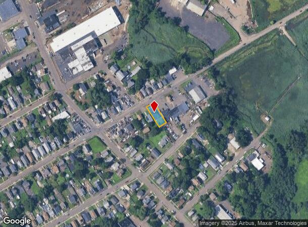
Property Record
42 Spring St, West Haven, CT 06516

NEARBY LISTINGS FOR SALE OR LEASE
Property Detail
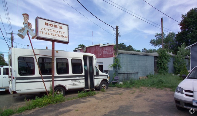
42 Spring St
Autorepair
New Haven
X
Connecticut
09009C0437J
0.15 AC
2025
West Haven
2025
Westchester/So Connecticut
154600
New Haven, CT
2,442 SF
WHAV-000055-000112
DEMOGRAPHICS near 42 Spring St
1 Mile
3 Mile
5 Mile
2024 Total Population
23,152
129,384
240,030
2029 Population
22,665
128,010
237,776
Pop Growth 2024-2029
(2.10%)
(1.06%)
(0.94%)
Average Age
34
36
38
2024 Total Households
7,543
49,643
94,257
HH Growth 2024-2029
(2.56%)
(1.06%)
(0.90%)
Median Household Inc
$52,447
$56,473
$61,032
Avg Household Size
2.50
2.30
2.30
2024 Avg HH Vehicles
1.00
1.00
1.00
Median Home Value
$180,430
$234,610
$251,984
Median Year Built
1949
1953
1956
Nearby Places
Map Layers
Map Styles
 Street
 Aerial
- Restaurants
- Banks
- Shops
- Fitness
- Groceries
PUBLIC TRANSPORTATION
COMMUTER RAIL
DRIVE
WALK
Distance
3 min
1.4 mi
DRIVE
WALK
Distance
4 min
1.5 mi
AIRPORT
Tweed/New Haven
DRIVE
WALK
Distance
Tweed/New Haven
14 min
5.8 mi
Freight Ports
Port of New Haven
DRIVE
WALK
Distance
Port of New Haven
8 min
3.6 mi
Nearby Properties
Address
Land Use
TOTAL SIZE
Lot Size
Zoning
Address
Land Use
TOTAL SIZE
Lot Size
Zoning
289,886 SF
2.21 AC
BD2
Address
Land Use
TOTAL SIZE
Lot Size
Zoning
56,359 SF
17.09 AC
RCPD
Address
Land Use
TOTAL SIZE
Lot Size
Zoning
347,604 SF
6.37 AC
RM2
Address
Land Use
TOTAL SIZE
Lot Size
Zoning
83,314 SF
2.14 AC
BA
Address
Land Use
TOTAL SIZE
Lot Size
Zoning
49,582 SF
1.62 AC
RH2
Address
Land Use
TOTAL SIZE
Lot Size
Zoning
50.14 AC
PRD
Address
Land Use
TOTAL SIZE
Lot Size
Zoning
81,870 SF
3.86 AC
RM2
Address
Land Use
TOTAL SIZE
Lot Size
Zoning
132,345 SF
3.48 AC
RH2
Address
Land Use
TOTAL SIZE
Lot Size
Zoning
302,262 SF
10.40 AC
RM1
Address
Land Use
TOTAL SIZE
Lot Size
Zoning
446,320 SF
BD1
Address
Land Use
TOTAL SIZE
Lot Size
Zoning
217,040 SF
2.20 AC
RH2
Address
Land Use
TOTAL SIZE
Lot Size
Zoning
101,654 SF
1.45 AC
PDU 14
Address
Land Use
TOTAL SIZE
Lot Size
Zoning
122,856 SF
1.66 AC
RH2
Address
Land Use
TOTAL SIZE
Lot Size
Zoning
133,767 SF
1.25 AC
BD2
Address
Land Use
TOTAL SIZE
Lot Size
Zoning
8,758 SF
12.74 AC
IH
Address
Land Use
TOTAL SIZE
Lot Size
Zoning
486,703 SF
2.12 AC
BD
Address
Land Use
TOTAL SIZE
Lot Size
Zoning
72,708 SF
1.91 AC
PDU 87
Address
Land Use
TOTAL SIZE
Lot Size
Zoning
117,902 SF
1.41 AC
BD
Address
Land Use
TOTAL SIZE
Lot Size
Zoning
318,210 SF
2.73 AC
BA
Address
Land Use
TOTAL SIZE
Lot Size
Zoning
316,781 SF
9.20 AC
PDU 94
Address
Land Use
TOTAL SIZE
Lot Size
Zoning
102,115 SF
0.77 AC
RH2
Address
Land Use
TOTAL SIZE
Lot Size
Zoning
180,310 SF
2.70 AC
RH2
Address
Land Use
TOTAL SIZE
Lot Size
Zoning
2.55 AC
BD
Address
Land Use
TOTAL SIZE
Lot Size
Zoning
57,339 SF
3.46 AC
RM2
Address
Land Use
TOTAL SIZE
Lot Size
Zoning
123,166 SF
2.33 AC
RH2
Address
Land Use
TOTAL SIZE
Lot Size
Zoning
42.52 AC
PF
Address
Land Use
TOTAL SIZE
Lot Size
Zoning
7,345 SF
3.09 AC
IL/RM2
Address
Land Use
TOTAL SIZE
Lot Size
Zoning
29,647 SF
0.99 AC
RH2
Address
Land Use
TOTAL SIZE
Lot Size
Zoning
123,518 SF
2.88 AC
RH2
Address
Land Use
TOTAL SIZE
Lot Size
Zoning
117,066 SF
71.34 AC
IH
The World's #1 Commercial Real Estate Marketplace
Connect with us
© 2026 CoStar Group
The information above has been obtained from sources believed reliable. While we do not doubt its accuracy we have not verified it and make no guarantee, warranty or representation about it. It is your responsibility to independently confirm its accuracy and completeness. Any projections, opinions, assumptions, or estimates used are for example only and do not represent the current or future performance of the property. The value of this transaction to you depends on tax and other factors which should be evaluated by your tax, financial, and legal advisors. You and your advisors should conduct a careful, independent investigation of the property to determine to your satisfaction the suitability of the property for your needs.