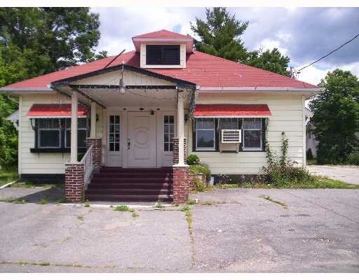
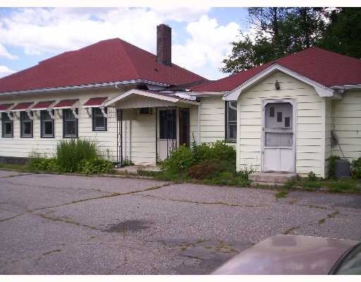
Property Record
42 Sullivan St, Wurtsboro, NY 12790
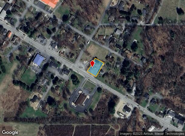
NEARBY LISTINGS FOR SALE OR LEASE
Property Detail
42 Sullivan St
Restaurantbuilding
Sullivan
X
New York
36105C0653F
2.000
2025
0.34 AC
2024
Hudson Valley Area
951302
Other Market Areas
2,628 SF
4003-107-0-0004-002-000
DEMOGRAPHICS near 42 Sullivan St
1 Mile
3 Mile
5 Mile
2024 Total Population
1,004
6,830
13,148
2029 Population
987
6,962
13,339
Pop Growth 2024-2029
(1.69%)
+ 1.93%
+ 1.45%
Average Age
45
38
40
2024 Total Households
451
2,485
4,774
HH Growth 2024-2029
(1.55%)
+ 1.73%
+ 1.47%
Median Household Inc
$63,158
$63,764
$80,361
Avg Household Size
2.20
2.70
2.70
2024 Avg HH Vehicles
2.00
2.00
2.00
Median Home Value
$184,374
$206,236
$250,131
Median Year Built
1970
1970
1974
Nearby Places
- Restaurants
- Banks
- Shops
- Fitness
- Groceries
PUBLIC TRANSPORTATION
AIRPORT
New York Stewart International
DRIVE
WALK
Distance
New York Stewart International
40 min
24.1 mi
SALE & LEASE HISTORY
LISTING DATE
SALE/LEASE

Sep 24, 2016
For Sale
Nearby Properties
Address
Land Use
TOTAL SIZE
Lot Size
Zoning
Address
Land Use
TOTAL SIZE
Lot Size
Zoning
505,953 SF
89.17 AC
I
Address
Land Use
TOTAL SIZE
Lot Size
Zoning
4,219 SF
86.85 AC
RAG1
Address
Land Use
TOTAL SIZE
Lot Size
Zoning
4,200 SF
39.73 AC
HC
Address
Land Use
TOTAL SIZE
Lot Size
Zoning
3,606 SF
60.55 AC
BR
Address
Land Use
TOTAL SIZE
Lot Size
Zoning
28,000 SF
16.50 AC
R1
Address
Land Use
TOTAL SIZE
Lot Size
Zoning
7,592 SF
13.78 AC
C
Address
Land Use
TOTAL SIZE
Lot Size
Zoning
924 SF
24.52 AC
R4
Address
Land Use
TOTAL SIZE
Lot Size
Zoning
2.35 AC
Address
Land Use
TOTAL SIZE
Lot Size
Zoning
4,893 SF
0.53 AC
C1
Address
Land Use
TOTAL SIZE
Lot Size
Zoning
1,568 SF
47.33 AC
RVP
Address
Land Use
TOTAL SIZE
Lot Size
Zoning
48,808 SF
3.64 AC
C1
Address
Land Use
TOTAL SIZE
Lot Size
Zoning
20,000 SF
5.17 AC
C
Address
Land Use
TOTAL SIZE
Lot Size
Zoning
17,135 SF
3.26 AC
Address
Land Use
TOTAL SIZE
Lot Size
Zoning
10,560 SF
2.76 AC
C
Address
Land Use
TOTAL SIZE
Lot Size
Zoning
6,210 SF
45.16 AC
RAG2
Address
Land Use
TOTAL SIZE
Lot Size
Zoning
9,026 SF
1.71 AC
Address
Land Use
TOTAL SIZE
Lot Size
Zoning
9,000 SF
17.67 AC
LNR
Address
Land Use
TOTAL SIZE
Lot Size
Zoning
Address
Land Use
TOTAL SIZE
Lot Size
Zoning
104.23 AC
Address
Land Use
TOTAL SIZE
Lot Size
Zoning
247.69 AC
RAG1
Address
Land Use
TOTAL SIZE
Lot Size
Zoning
1.41 AC
Address
Land Use
TOTAL SIZE
Lot Size
Zoning
Address
Land Use
TOTAL SIZE
Lot Size
Zoning
3,440 SF
1.16 AC
Address
Land Use
TOTAL SIZE
Lot Size
Zoning
1,624 SF
17.75 AC
Address
Land Use
TOTAL SIZE
Lot Size
Zoning
1,500 SF
56.20 AC
R1
Address
Land Use
TOTAL SIZE
Lot Size
Zoning
4,782 SF
0.57 AC
R1
Address
Land Use
TOTAL SIZE
Lot Size
Zoning
8,239 SF
176.67 AC
I
Address
Land Use
TOTAL SIZE
Lot Size
Zoning
10,086 SF
0.29 AC
Address
Land Use
TOTAL SIZE
Lot Size
Zoning
80.80 AC
Address
Land Use
TOTAL SIZE
Lot Size
Zoning
1,008 SF
3.95 AC
R4C
The World's #1 Commercial Real Estate Marketplace
Connect with us
© 2025 CoStar Group
The information above has been obtained from sources believed reliable. While we do not doubt its accuracy we have not verified it and make no guarantee, warranty or representation about it. It is your responsibility to independently confirm its accuracy and completeness. Any projections, opinions, assumptions, or estimates used are for example only and do not represent the current or future performance of the property. The value of this transaction to you depends on tax and other factors which should be evaluated by your tax, financial, and legal advisors. You and your advisors should conduct a careful, independent investigation of the property to determine to your satisfaction the suitability of the property for your needs.